Update: I just finished fixing some serious formatting issues. I wrote this before I learned that what the public sees is not what I see while writing the blog. I also discovered that the State of Illinois saw fit to break all of my aerial map references. The prefix needs to be changed from "isgs.illinois.edu/nsdihome/" to "clearinghouse.isgs.illinois.edu/". That mind numbing clerical work is going to have to wait for another day. If you do get a 404, you know what to change in the meantime.
While researching the
Illinois Valley and Northern Railroad (IV&N), I discovered quite a few railroads went through or to
Streator, IL. Rather than trace each abandoned
route individually, I decided to analyze all of the railroads in Streator so
that I have to download and analyze the aerial maps only once. The railroads were built between 1867 and 1882.
My
1928 and 1973 Railroad Atlases show 8 lines going to Streator. The direction is where the route is from and the next town on the route is included in parentheses. The colors are for the map below. The "***" use below stands for the following corporate linage: BNSF(1996)/BN(1970)/Santa Fe(1888)/Chicago & St. Louis Railway (1885)/Chicago, St. Louis & Western Railroad (CSL&W, 1881)/Chicago, Pekin & Southwestern (CP&S) (
Wikipedia).
- Blue: East (Dwight) and West (Lostant): NS/NYC/Chicago, Indiana & Southern/Indiana, Illinois, and Iowa, 1881 (StockLobster), 1882 (BiogInBlack).
- Green: East (Dwight): Aband/ICG/GM&O/Chicago & Alton (C&A) (Dwight Division), 1870 (GenealogyTrails).
- Green: West (Wenona) is Aband/ICG/GM&O/C&A/"Stub End Road," 1868 (BiogInBlack). In 1870 this segment would become part of the Dwight Division of Alton (GenealogyTrails)
- Purple: Northeast (Mazon): ***/Chicago and Illinois River Railroad, 1876. It was the CSL&W that extended the track from Mazon to Corwith in 1881. Before 1881 it used trackage rights on the Chicago & Illinois River Railroad (C&IR). The C&IR became part of Alton. (GenealogyTrails, Wikipedia)
- Orange: North (Oglesby):
Aband(1980)/BN/CB&Q/Ottawa, Oswego, and Fox River Valley (OO&FRV), 1867 (GenealogyTrails). 1867 is wrong. That is when the corporation completed the segment to Wenona (see below). Coal had been discovered in Streator, and they ignored their charter in order to get a quick connection to ship coal and bring in mining machinery. 1871 is when they completed work on the chartered route (BiogInBlack).
- Yellow: Northwest (Oswego): Illinois Railway/Illinois RailNet/BNSF/BN/CB&Q/Illinois Valley and Northern Railroad (IV&N), 1870 (BiogInBlack).
- Purple: Southwest (Ancona): ***, 1873 (GenealogyTrails, Wikipedia). This route included trackage rights on the Toledo, Peoria and Warsaw Railway (later, Toledo, Peoria and Western) between Eureka and Washington. Santa Fe's mainline to Kansas City joined the CP&S at Ancona making the Ancona-Pekin segment the only Santa Fe branch line in Illinois. This branch is now abandoned except for a segment servicing Morton, IL from NS/N&W/NKP. (Wikipedia)
- Light green: Southeast
(Pontiac): Aband/N&W/Wabash/Chicago & Paducah/Fairbury, Pontiac and Northwestern, soon after CP&S was completed to the southwest (GenealogyTrails).
Red is used for an abandoned track. Black is used for a connector for
which I don't know the owner. It would be either BNSF/Santa Fe or
NS/NYC. This connection allows about 8-10 trains a day to bypass
Chicago. Light blue is an industrial spur. OO&FRV abandoned 0.4
miles in Streator (
BNSF Track Segments,
Segment 60). Thus the south end of OO&FRC is "dashed." Looking at a
satellite map, the tracks seem to stop 40 feet south of E. Grant St.
But that does not make much sense. Why would they maintain crossing
signals that protects only 40 feet of track?
Junctions:
Railroads were needed to serve the coal mines in the town.
Streator was known for its coal. It had 25,000 acres of un-mined coal
that was pronounced by the C.B. & Q. fuel inspector as the best
engine coal in Northern Illinois. It had a mining capacity of ¾ of a
million tons of coal annually. (Museum)
Other industries developed that also needed the support of railroads. They helped sustain the town after the coal ran out in the 1920s. Because of shale and clay deposits, plants that made bricks, tiles, etc. started in the mid-1870s. Because of the 99.44% pure silica St. Peter Sandstone and limestone in the region and coal to heat those ingredients, a glass industry started in the early 1880s. One plant, sponsored by Anheuser-Busch breweries made bottles and other plants made flat glass. (BiogInBlack) By the early 20th century, Streator held the title of "Glass Manufacturing Capital of the World"
In 1912 Streator reached the markets through seven lines of railroad
radiating in twelve different directions, covering 45,000 miles and
reaching thirty-one states and territories. It had thirty passenger and
forty freight trains daily and handled eight million pounds of freight. (Museum)
In 1928, Streator had 9 "spokes." Five of these still exist ---
Illinois Railway and two each for SanteFe and NYC. Note above that there were 12 spokes in 1912, so 3 were gone already by 1928.
I used a 1939
aerial map that I downloaded from the
ILHAP site. The
first issue I addressed is that it looks like there used to be a
connection across the north part of town between Sante Fe east and NYC
west, but it is now severed. Looking at
a satellite image,
the connection is not only severed, the road map is wrong because all
of Sante Fe's east/west track across the north has been removed.
To confirm that the connection between the Sante Fe
and NYC east existed back in 1939, I got an aerial map to the
southeast of
Streator. Not only did it exist, what is now
Katchewan Park was a rail served industry back then.
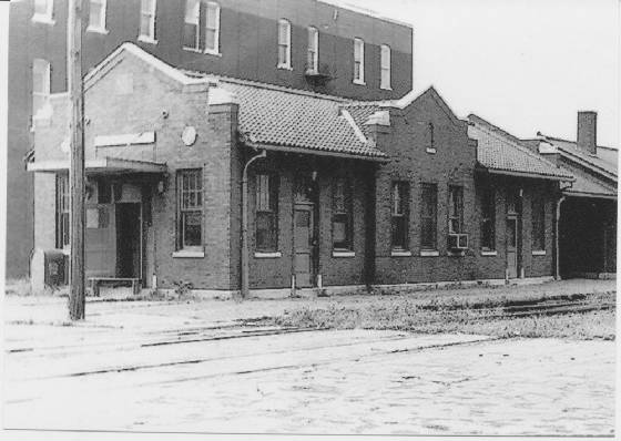
While I was looking at the aerial map, I found Santa Fe's roundhouse. I also spotted a depot on the
west side of their yards. Looking at
a satellite image, it not only still stands, it looks well maintained. As I would expect, the freight house that was north of the depot is gone. But I can't reconcile the crossing and tall building in the background of the following photo with the aerial photo. This looks like an issue for a field trip.
There
is another set of tracks leaving Streator along the NYC east route
because it keeps going southwestish after the NYC turns east. You can
easily follow the tree lines and land scars on the satellite map to
Cornell, which has a big isolated grain elevator, to Rowe and through
Pontiac. This would have been the Wabash. Following this RoW back into
Streator on the west side of the NYC RoW, there are trees to follow
until you get
south of Lundy.
Switching to Streator's aerial map makes it obvious why I could not
trace it any further on the satellite image --- buildings have been
built over the RoW.
Before discussing the Wabash RoW some more, I'm
pursuing an industrial branch that used to go towards the river. The
red lines to the right indicate most of the trackage of the spur. The industrial area
was an industry that evidently had tank farms. And between that industry
and Shale Road was a strip coal mine!
Rather than describe were the RoW went, it is time
for another aerial map excerpt. Note that the nw/se diagonal tree line
on the right of the above satellite image was the Wabash RoW. What is
now a park was vacant land in 1939. I wonder what used to be there. The Wabash connected with the Sante Fe at the top of this triangle. It then continued a few blocks north and terminated in a small yard and connected to the NYC, which
connected to the two CB&Q routes.
The
NYC RoW goes up along the right side of the aerial map excerpt to the right until it turns
northwest when it meets the Alton RoW. To investigate the Alton route, I
include another excerpt that has the NYC and Alton crossing of the Santa
Fe in the lower-right corner.
The Alton entered a small yard before it
curved west as it crossed the NYC and went westish across the Vermillion
River. It then turned southwestish in what is now the River View
Cemetery. Then it is easy to follow the RoW on the satellite map until it
gets to Wenona. I think the IC route through Wenona was the originally
chartered and constructed route. It looks like that IC segment is now also
abandoned.
Based on the aerial
photo, I originally thought the Alton depot was near Broadway and Vermillion.
But now I suspect it was on the east side of Bodznick Park.
The Alton RoW to the east leaves town as a straight line to the southeast. It crosses the NYC line that has already turned east,
then a couple of tributaries to a creek, then heads due east through Blackstone, and enters Dwight on the south side where it connects with the UP/SP/ICG/GM&O/Chicago & Alton mainline.
Just north of where the Alton crossed the NYC, the IV&N connected to the NYC. I could not find an entry on
Bridge Hunters for the ghost bridge over the Vermillion River.
Need to add: branch of Chicago, Ottawa and Peoria Railways interurban from Ottawa to Streator was built in 1908. In 1923, the CO&P became the Illinois Valley Division of the Illinois Traction System. It was abandoned in 1929. (
Wikipedia)
Update: Jerry's comment:
Leaving Streator headed west. GP35 2835 leads a typical lash-up back in 88'. Those were the days.
I may be able to recreate the tree colors, but there is no way I could recreate the engine colors. Two of the six engines are in the "Shouldn't Paint So Fast" livery because SP and SF where expecting to merge as SPSF. Also known as the Kodachrome livery.
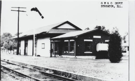
Richard's comment: "
Alton gas electric in Streator crossing the Santa Fe" It was posted because it was an example of a gas electric unit. But I include it as insight of the track layout in the town.
 |
Dale Burkhalter posted
At Streator, Illinois NYC Kankakee Line. Around 1962.
Looking Northwest. |
Other comments by Dale:
The building on the left is the NYC depot. The signal is for the AT&SF Chicago mainline.
At one time, Streator had five railroads coming through town. The NYC, AT&SF, GM&O, N&W, & CB&Q. All were branch lines except the AT&SF. Also, at one time, Streator was known as the glass bottle capitol of the world.
After I posted a link to this article:
Hired onto the NYC in 1967. At that time there were 5 railroads going into Streator.
Dennis - The black connector line connects the NYC track to the AT&SF track at NYC's Streator Jct. I believe the Eastern section was NYC and the Western section was AT&SF. We interchanged trains their instead of taking them downtown to AT&SF's Streator yard. So, I assume it was jointly owned.
(
Facebooked)
Bricks and glass is why so many railroads built to this town.
 |
Roger Kujawa posted
Streator, Illinois Clay & Coal Pit Mining Barr Clay Plant 1913 Postcard |