Saturday, January 27, 2018

New Carlisle, OH: Steel Bin Collapse

(3D Satellite, a "before" image is at the bottom)

I normally record bin failures in the Steel Grain Bins: vs. Concrete Silos posting. But since this collapse has a major impact on the community (it cut off the state highway that provides access to town on the west side), it gets a separate posting.

Rural American History Captured shared
Grain Elevators of North America shared
Seed Consultants posted
Collapsed bin in New Carlisle, Ohio spills 10,000 tons of corn onto State Route 571.
Jerry Elder Lol about 375,000 bu [That doesn't strike me as a "laughing out loud."]
Jenny Bunch Just a block from our home! It's created a lot of excitement around here but at least no one got hurt. So sorry for the owners and those involved.
[3D Satellite I don't see any side streets for the OH-571 traffic to take around that pile.]

N H
Scott Trostel posted nine photos with the comment:
Miami Valley Feed and Grain at New Carlisle, Ohio -- ongoing clean-up 1/24/2018. About 370,000 bu of corn spilled out in a steel tank collapse during the night of 1/21/2018. Two out-buildings were destroyed, a State Highway is still closed.On 1/24/2018 the clean-up crews have finally broken through on SR 571, but considerable work remains to get the grain back away from the edge of the road. The drive-thru has been collapsed and there is considerable grain piled around the elevator.
John Harker how many bushels was the tank, did it split . looks a non corrugated steel tank?

Scott Trostel About 365,000 to 375,000 bu new corn spilled. No official cause known, but two of my photos show bolted tank seams. It was smooth wall steel, about 48 years old.


1

2

3

4

5

6

7

8

9
Before image:
3D Satellite, looking West

Thursday, January 25, 2018

Bellefontaine, OH: CP-141/High Tower/BS Tower: Big4 vs Big4 vs NYC

(Satellite, Street View)

See hub for a map.

Kenny Wilkerson posted
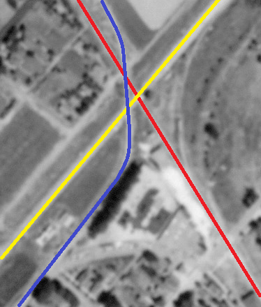
BS Tower, originally known as "High Tower", then later "CP-141" in downtown Bellefontaine, Ohio as it looked last weekend [Dec 2017]. The telegraph call sign "BS" stood for "Bellefontaine South". A BN, (Bellefontaine North) operator was once located in the yard office in the yard on the north side of town. BS controlled the diamond and connections between the CCC&StL(Big 4)/NYC/PC/CR Sandusky to Springfield route, part of the Ohio Division, and the Cleveland to St. Louis route, part of the Cleveland Division which crossed at grade at BS Tower. The St. Mary's Branch also diverged near the tower. The St. Mary's and Sandusky lines are long gone and the Springfield route is part of the Indiana & Ohio Rwy., a Genesee & Wyoming property, although it doesn't quite reach the tower. The Cleveland to St. Louis route is now CSX.
BS/High Tower has gone through some colorful changes in its life, starting out as a wooden 3rd and 4th floor-only tower on stilts. At some point years later the 1st and 2nd floor areas were filled in with red brick. Again years later the top 3rd and 4th wooden floors were removed and the two brick floors remained. In the Conrail era the tower was painted in the customary light gray with dark gray trim which it retains to this day.
Cory Behrendt After about 1962 or so, BN actually controlled BS. Amazing it has stood nearly six decades after its closure. I have always wondered how much CSX would want for the property. Although they would likely want it moved, I always thought it would be a cool spot for a viewing platform.
Update:
Here is one of the forerunner tower buildings.
Brian Rasmussen posted
Si Herring Collection
Big Four Tower at Bellfontaine OH
1910
Thomas Wentzel shared

Darren Reynolds posted three photos with the comment: "BS tower (Bellefontaine,OH.)   Went through some changes???    Any information would be appreciated..."
Jim Kelling: It’s now mostly hidden by trees and vines, but still there
Craig Harris: Comparing the pictures, it looks like the upper portion of the tower was removed above the brick line. I have seen this done on some NYC brick towers where the lower portion housed a lot of electrical equipment that replaced the mechanical apparatus in later years!
1

2

3


Tanner Wical posted
NYC Sharks in Bellefontaine, Ohio
(Old YMCA is on the left)

American-Rails.com posted
An A-B-A set of New York Central RF16's, along with what appears to be a GP7 and two F7A's, lead their freight past BN Tower in Bellefontaine, Ohio during the 1960's. Jim Hawk photo.
B Tupper Upham: BS Tower, not BN
Bob Hillard: I’m pretty sure it was B N tower
Butch Stone: BS ?
[No wonder I'm confused. So are the experts.]

Stu Nicholson posted two photos with the comment: "Former Big Four Tower at Bellefontaine, Ohio fades into the brush. This controlled the junction between the Big Four and the PRR's 'Bradford Line'. Today, it's just a bystander to the traffic that CSX generates."
[I should have read the comments before I spent time looking for PRR on various maps. Also, I don't think it is a bystander anymore. Someone has labelled "Former Site of Conrail CP 141".]
Cory Behrendt: The PRR definitely did not go through Bellefontaine.
BS tower ("Bellefontaine South") was the junction between the Big 4 Cleveland to Indianapolis Line and Springfield to Sandusky Lines, with at one time a branch from Peoria to St. Marys meandering through.
1

2
 
Larry Candilas commented on Stu's post
July 11 1995

The topic of BS vs. BN requires more research and some serious editing. I need to start with:
"Way back, there was another tower out at the north end of Bellefontaine Yard, called BN Tower. The signal set north (east) of that was a full set of crossovers known as Turner. I'm not sure when CR got rid of the crossovers but I remember them at the U.S. 68 crossing I think."
"Don't quote me on the date of closure, but BS (previously called High Tower because it was 4 stories way back when) Tower closed in the 60s and the plant was remoted to BN yard office on the east side of town (I know that much, just not the exact date). BN yard and the crew dorm closed in 1983 and CP 141 was remoted to Ridgeway which was shortly thereafter remoted to Marion when Ridgeway closed."

And note that this interlocking diagram (source) shows that BS was controlled from BN.


Lincoln, IL: Athol (JN) Tower: UP/MoPac/GM&O/Alton vs CN/IC/PD&E vs Aban/IT/ITS

(Satellite, the tower is long gone)

About a third of the way down on the right is the tower building.
See Stetson China for credit information for the photo
 Color code convention: red for the Peoria, Decatur & Evansville branch of the IC, yellow for the GM&O, and blue for the Illinois Terminal.
Steven Kent posted five photos with the intended comment: "JN Tower Lincoln, Illinois."

1

2

3

4

5
Update:
Steven Kent posted

Peter Zimmermann posted
Old postcard view of the interlocking tower and Illinois Central station. The IC line was originally the Peoria Decatur & Eastern Railroad, they crossed the Chicago & Alton Railroad main line here as well as the main line of the Illinois Traction System[later Illinois Terminal RR] also crossed here.
The IT and Illinois Central line are now abandoned, the latter by ICG in the 1980's. The C&A main line is now the Springfield subdivision of the Union Pacific which primarily sees Amtrak trains between Chicago & Saint Louis.
Dennis DeBruler The PD&E is probably my favorite ghost railroad because I used to take IL-130 to Evansville rather regularly. http://industrialscenery.blogspot.com/.../peoria-decatur...Dennis DeBruler Posts about aspects of the abandoned PD&E: https://towns-and-nature.blogspot.com/search/label/abanPDaE

Roger Kujawa posted
Passenger Depot Illinois Central Railroad Lincoln, Ill postcard P.D.E Division

Roger Kujawa shared
David Thompson
This crossing was known as "Athol" on the C&A / GM&O.


Lincoln, IL: Stetson China Company

(Satellite, all of the buildings and the industrial lead are gone)
Steve OConnor shared
Can anyone identify which rail line is which in this photograph from Lincoln, Illinois? The factory was built on a triangular-shaped area near the intersection of the Chicago & Alton, Illinois Central, and Illinois Traction System (ITS, interurban) railroads.
Bill Edrington The view in the black-and-white photo basically looks west. The Alton/GM&O main line crossed both the IC's Peoria District and the IT main line at Athol (JN Tower). The tower sat on the right side of the GM&O if you were going from Springfield to Bloomington, and also on the right side of the IC if you were going from Decatur to Peoria. The IT crossed both lines here after paralleling the GM&O through Lincoln, and then headed straight north toward Mackinaw Junction.

Steve commented on his posting
1940 Aerial Photo from ILHAP
Dennis DeBruler commented on Steve's posting
 I marked a 1940 aerial using red for the Peoria, Decatur & Evansville branch of the IC, yellow for the GM&O, and blue for the Illinois Terminal.
Dennis DeBruler commented on Steve's posting
 Using the same color conventions, I marked up the photo.
Dennis DeBruler The IT followed the IC out of town and then turned north. You can still see the treeline where it left town. https://www.google.com/.../@40.1656363,-89.../data=!3m1!1e3


Dennis DeBruler commented on Steve's posting
The third leg of the triangle was an industrial spur. You can see a boxcar parked at the building. I put the spur in orange and the Main Business Entrance side along Kickapoo Street in purple.

Wednesday, January 24, 2018

Bellefontaine, OH: A Big Four Hub, Railyards and Roundhouse

(Satellite, roundhouse remnants, see more below)

(Update: see tower)
One of 26 photos posted by Tanner Wical

The 2005 SPV Map shows the northern and western spokes are owned by CSX and the southern fork is owned by IOCR --- Indiana & Ohio Central Railroad. But a satellite image shows that the IOCR track does not connect to CSX. It stops at Water Avenue.

Tanner Wical posted 30 photos.

One of 26 photos posted by Tanner Wical
Postcard
Brian Rasmussen posted
1910  CCC&StL shop complex at Bellefontaine OH.  From postcard image on "Worthpoint"
Thomas Wentzel shared

Raymond Storey posted two photos with the comment: "BELLEFONTAINE OHIO."
1

2

The railyard is now brownland.
Satellite

According to a topo map, the roundhouse was almost a full circle. Evidently NYC already took official ownership of Big Four by 1944. I could find no traces of the railyard on the south side of town. And all but the mainline tracks have been removed from the skinny yard on the north side.
Dennis DeBruler commented on Thomas Wentzel's share
According to this topo map, we can still see some of the foundation of the roundhouse here:
1944 Bellefontaine and East Liberty Quadrangles @ 1:62,500

Paint doesn't have a widget for arcs so I made a circle and added a yellow line where there was no building to make room for the lead track.
Satellite plus Paint

2 of 3 images posted by Scott Trostel with the comment:
I am pleased to introduce my newest book. BELLEFONTAINE, OHIO, RISE AND FALL OF A BIG FOUR TERMINAL. The book is 184 pagws of the town and development of a terminal on the newly formed Big 4. From its earliest day as a stop in the fabled Mas River & Lake Erie Railroad, a second line, the Bellefontaine & Indiana built into town. Through a succession of owners, It was Melville Ingalls who brought it all together in 1889 and established the Big 4. He brought the first shops to town, along with BN Yard and a state of the art roundhouse. The shops went on to overhaul locomotives as well as construct new locomotives.. As things progressed, 20 additional stalls was added to the roundhouse. The first of three Railway YMCA,s was constructed. The depot was constructed at BS Junction to handled 20 plus passenger trains daily. As a terminal with shops it was second in size to Beech Grove. It went on to have two additional yards, Gest and East, the three were reportedly handling over a million cars a year. The Railway YMCA reported 4,000 members. It experiences a boiler explosion in the roundhouse in 1942, then in 1943 a fire consumed the roundhouse requiring 10 fire departments to contain. Then the depot burned in 1946. The terminal came to an end with the introduction of diesels and closed out steam locomotives in 1956. Avon Yard at Indianapolis took most of the business in 1961. The stockyards and icing platform were closed and only two stalls of the 39 stall roundhouse remained in operation. BS junction was closed circa 1963 and slowly Guest Yard was abandoned and BN Yard was cut back to storage, Conrail moved the crew change point and there was no need for a Railway YMCA. It has 197 photos' and 17 maps. I can be ordered at Cam-Tech Publishing. 4890 E Miami-Shelby Rd., Fletcher, Ohio 45326-9766. Price is $46.95 plus $6.00 S&h
Scott Trostel shared
a

b


Tuesday, January 23, 2018

Chicago, IL Depot: IC Pullman


Paul Petraitis posted
As a Chicagoan (and a former HO modeler!) I love generic trackside buildings! Look at the heated shack that popped up near the old Pullman station! The year is 1900. The kid on the bike is ten years old so is the photographer Tom Ehrtsmann...he loaned me his 4x5 glass negative in 1969 I printed it way back when and scanned it yesterday!
The reason for this posting is the background in his comment.

Paul commented on his posting
Dennis DeBruler It took me a while to find, but the building in the left background is still standing. https://www.google.com/.../data=!3m1!1e3!4m5!3m4...
Paul responded to my comment with a comment on his posting, cropped
Well yeah that's the clock-tower/Administration building of the Pullman National Monument at 110th and Cottage!
[This gives us another view of the smokestack with some neat architecture.]

1938 Aerial Photo from ILHAP
Dennis DeBruler commented on Paul's posting
I think of 1938 as old. But a lot changed between 1900 and 1938 --- e.g. track elevation and an addition to the factory.
Paul Petraitis Tracks were raised in 1914/15 around Pullman/Kensington

Sunday, January 21, 2018

Elgin, IL: State Mental Health Center (Hospital) Heating Plant

It is interesting how the name has changed over the decades to be more politically correct. I see Google has it labeled as "Illinois Department of Human Services."
Mark Llanuza posted
One the second to the last coal empties going back to the IC Railroad interchange at Coleman Jct at South Elgin IL 1973 heads south coming back from the ILLinois State Hospital going past the Fox River Museum in South Elgin IL.
I had trouble locating the Mental Health Center, even though it is big, because the 2005 SPV Map showed it leaving the Aurora, Elgin & Fox River near the current trolley museum rather than where it switched to streetcar running on State Street. And not only have the buildings changed a lot since 1939, the streets have changed. I start with the 1939 aerial to find the track. The SPV Map indicated the branch went west, then north, then curved back east. That is consistent with what I saw on the aerial view. Note the powerhouse has only one smokestack back then.
1939 Aerial Photo from ILHAP
Today, we can still find a land scar of the track.
Satellite
Andrea R.
According to Historic Aerials, there was still just one smokestack in 1946. But in 1953 we see the two smokestacks that are still standing today.
Satellite

A topo map labeled the interurban line north of the IC connection as STATE HOSPITAL RR.
1949 Geneva Quad @ 24,000 via Dennis DeBruler

These comments on that topo map are relevant to these notes:
Comments on a post

They have also added a centralized cooling function.