The title used to contain: "Ohio River breaks record in early April," but I could not find a reference for that. So I removed it when I added the 1972 flood.
This flooding happened in early April. I ignored it at the time, but, when I came across this video, it occurred to me that this flooding was also in 2024. Note that the parks are doing their job of functioning as floodplains. Not only is the
Point Fountain underwater, so is the Three Rivers Heritage trail on the north side of the Allegheny River. Thus, the
Heinz Quay boat Launch would also be under water.
Dave DiCello
posted for photos at 11:30am on Apr 4, 2024 with the comment: "Another set of flooded #Pittsburgh images, this time from this morning. I was there when the rivers hit their highest Point, and water was spilling into Point State Park and onto Allegheny Landing. It almost reached Point State Park as well. I've never seen it this high before."
 |
| 1 |
 |
| 2 |
 |
3
[The River Rescue is normally in the river, but not that far in the river. They normally can access their rescue boats with a gangplank. At this time, they would have needed a boat to get to their boats. This photo also shows how dangerous river debris can be.] |
 |
| 4 |
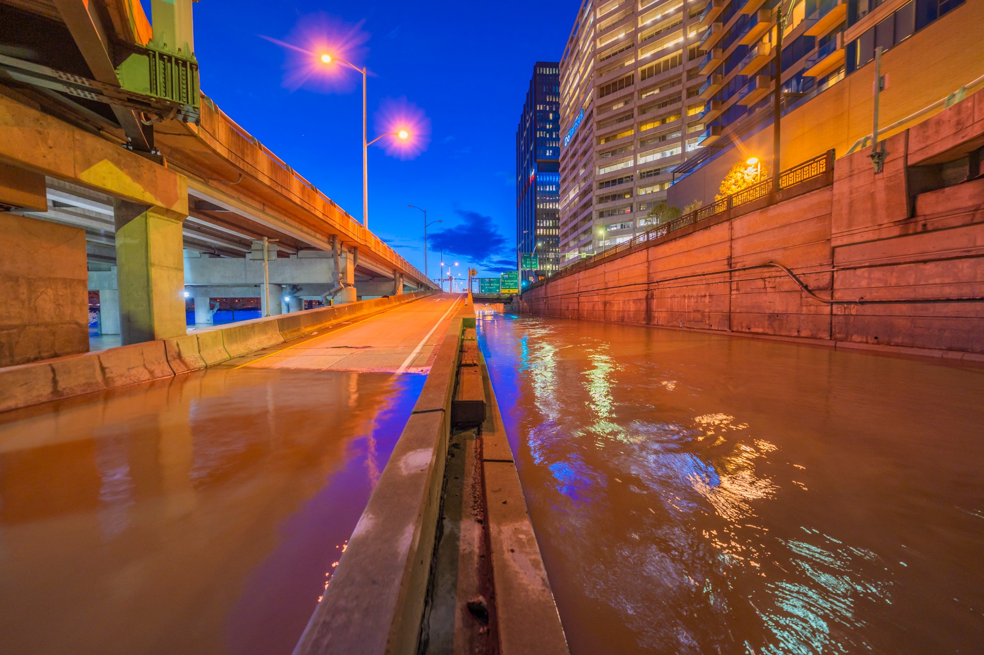
It wasn't just parkland that got inundated. This is the
10th Street Bypass.
 |
PittsburghMagazine, 1 of many photos by Dave DiCello
Photos: Record Flooding Hits Pittsburgh
"According to the National Weather Service, the Ohio River was observed at 28.37 feet early Thursday [Apr 4] morning. That range signifies a major flood according to their measurement system. A flood is officially called for the Ohio River when the water level is observed at 25 feet. The flood is considered to be major at or above 28.5 feet. The river’s water levels are forecasted to drop to 17.7 feet by Monday, according to data from the NWS." |
In addition to river flooding, Pittsburgh is also vulnerable to flash flooding because of its hills.
 |
axios, Source: Pittsburgh Public Safety
Up to 4" of rain fell before 9:30 pm Thursday [Apr 11].
🌧️This is already the 3rd wettest April on record (and likely the 1st by the end) 🌧️This is the wettest 1st 11 days for any month on record 🌧️This is the only time the 1st and 2nd greatest daily rainfall for a month have occurred in the same year (4/2 & 4/11) 12:57 AM · Apr 12, 2024 |
Back in Aug 2011, a flash flood killed four people.
 |
ToledoBlade
"2.1 inches of rain fell in an hour during the evening rush, said Rihaan Gangat, a meteorologist for the National Weather Service. But an earlier storm meant the region was drenched by 3 to 4 inches of rain overall on Friday....Hills line both sides of the section of Washington Boulevard that flooded, making it almost like a valley running between them. To the west is Highland Park, one of the highest spots in Pittsburgh. The boulevard slopes down to the north toward the Allegheny River. So when rains hit, water comes rushing in from three directions." |
May 2025 Flood
2025 has also been a very wet year in many parts of the USA.
 |
View Pittsburgh posted
All the rain 🌧️ that hit south of Pittsburgh is making its way through town via the Mongahela River. The Allegheny River on the left is clearing up a little more each day. Together they create the equivalent of a swirl ice cream cone.
Mary Roberts: Somewhere I've read that the Allegheny has a mostly rocky bottom and the Mon has a natural silt bottom, but probably also from all the decades of dredging for the barges . Makes for interesting photos for sure! Chris Herrig: Mary Roberts The Allegheny also flows faster than the Monongahela. I don’t know if that could also have an effect on its appearance. Mary Roberts: Chris Herrig oh yes, I've heard that also! It definitely might. |
Hurricane Agnes
I'm surprised the hurricane was this strong this far inland.
Heinz History Center
posted seven photos with the comment:
#OnThisDay [June 24] in 1972, a flood caused by Hurricane Agnes reached its 35.8-foot crest in Pittsburgh. After its inception off the coast of Yucatan on June 15, the hurricane’s path made an unexpectedly sharp turn and wreaked havoc on much of Pennsylvania. In Pittsburgh, the storm dumped 11 inches of rain during a three-day period.
Only two floods in Pittsburgh history rank worse than Agnes: the St. Patrick’s Day Flood of 1936 and a flood on New Year’s Eve in 1942. Fort Pitt Museum records indicate that when Agnes struck the Point, 45 inches of floodwater inundated the building.
📸 Downtown Pittsburgh after Hurricane Agnes, c. 1972. Kathleen Reilly Negatives, Detre Library & Archives at the Heinz History Center.
Monica Galley: It was my birthday and Alice Cooper was at Three Rivers stadium. We had tickets to go. When we woke up that morning, my father was home, he worked at Pittsburgh National Bank, now PNC, at 5th and Wood. He said no concert for your girls tonight, downtown was flooded, along with our basement. What was worse, my parents had just remodeled the basement for my brother and me as a hang out spot, pulling out the lime green shag carpet, naugahyde furniture and my new stereo. I will never forget the mud and smell.
Sep 11, 2025 Flood
I was not aware of this flood until this post showed up on my feed. The Midwest has been complaining about a drought. And then I read the comments. Melissa stole some photos from the 2024 flood.
4 of 28 photos
posted by Melissa Dave with the description:
Last night the rivers in Pittsburgh rose even higher than originally forecasted. The Ohio River hit 28 feet early this morning which is the highest level since 2005! In some of these photos you can see the fountain at the point is almost completely covered except for the very top of it. Just absolutely crazy to see!
I also saw what appeared to be a river otter (or maybe its a beaver) swimming in the flooded entrance to the Gateway Clipper.
I think the craziest thing I saw all night was the huge debris pile stacked up behind the River Rescue next to PNC Park. I went down there to shoot a photo of the river level gauge and it was completely covered with debris. A large chunk of metal was covering it which appears to be from an old boat or barge that had been stuck by the 16th St Bridge for several years.
 |
| a |
 |
| b |
 |
| c |
 |
| d |
 |
| Anonymous participant 134 commented on Melissa's fraud. |


.png)
%20Facebook.png)