Thursday, May 31, 2018

Branch Junction, IL: IC vs. IC vs. Missouri Illinois

(Satellite) You can still see the tree line of where the Missouri Illinois went to the East.  According to the SPV Map, MI went through Robinett and Selmavill before it joined the UP/C&EI  on the south side of Salem. It went through Salem along Blair Street.

Jacob Hortenstine posted
Branch Jct north of Centralia Illinois Chicago main to the right charter line to Freeport Illinois straight north.
Daniel C Carroll Jr. The Illinois Central's charter from the Illinois legislature dated February 10, 1851 stipulated construction of both the main line to Freeport and Galena, and the "Chicago branch" as well. The latter wasn't an afterthought, though it obviously became more important. The IC's original "main line" has since been severed.

The Missouri-Illinois Railroad was also a participant at Branch Jct.

It would be nice if the people who posted and reposted other people's images would give credit to the original photographer. This image was shot by John W. Barriger and can be found on Flickr. Per Jon Roma
It looks like the "branch" line to Chicago has been double tracked but the "mainline" up central Illinois is just single tracked. Artists in the 1800s adding a bunch of black smoke to a smokestack wasn't always "artistic license." This smokestack shows that it was sometimes true.

Looking at the satellite image, the charter line still has track. But that track stops before the first crossing to the north, less than a mile away.

Tuesday, May 29, 2018

Michigan City, IN: Monon's Freight House and Sand Dunes

Wayne Hudak posted several historical photos of large sand dunes that used to be near Michigan City with the comment:
SAND SAND SAND and more SAND. NW Indiana sand has been well known for it's great quality for glass making. Photos are the Hoosier Slide. If people had not come along to save the Dunes we might have had no sand left! A great atrocity happened in Michigan City 100 years ago (it was completely gone by 1920) when the well known "Hoosier Slide" was mined out to glass makers, mainly Ball Glass in Muncie Indiana. The NIPSCO power plant in Michigan City now sits where the Hoosier Slide once existed. Another smaller sand mining operation existed until WW2 along the south side of US20 between County Line Rd and Ripley Street in Gary/Lake Station, where the Dunes Drive In sat. The Wabash RR serviced that mine and the area was called "Calumet" by the railroad. Miller's early days sand was heavily mined with as many as 100 railroad cars a day shipped to Chicago.
Mark-Patty Sadowski Wayne Hudak Another location in that area that might have been used for sand.The New York Central ,on the Porter line going through Portage had a spur that left the main line in a area in Portage between Driftwood and Tonia went north almost up to an area around I-94.I can recall going along I-94 in the 70’s and looking down and seeing tracks ending there.I did a search on Historic Aerials for the year 1951 and saw that the line ended in a area north of I-94.There were even railroad cars sitting on the north end of that line.In 1959 the area on the north end was gone.Thanks for another great story.
Wayne Hudak I remember when the "sand spur" was still there in the 80's. It served the Samuelson sand company. Usually Conrail gons sat at that location just north of Rt20. The line had been planned to connect with the SShore and NYC along Rt12 but, of course, never materialized. Wished I had taken photos!
Mark-Patty Sadowski Wayne Hudak Many Thanks.I assume the train crews would have come out of Gibson
Wayne Hudak Mark-Patty Sadowski I remember seeing CR push gons across Old Porter Road heading north as there was no runaround track on that spur. When trains came out of Gibson, they ran around the cars just east of Willowcreek. There were 2 runaround tracks there. (115 CAR SIDING)

The comments indicated that a lot of sand was mined from the south shore because the dunes were all along the south shore. If the sand had not been removed, there would have been no place for industry and towns. But I'm glad they preserved at least one dune. One advantage of having kids is that we visited Mount Baldy, at least a couple of times, long before a kid fell into a sink hole created by rotted tree trunks. The kids, and I, had fun going up and down that pile of sand.

One photo is of particular interest because Wayne shows where the Monon freight house was.
Wayne Hudak posted
Looking at a 1952 aerial photo, the freight house was about where Mateys is now.

William Shapotkin posted
Areal photo of Michigan City, IN looking south in 1967. Is that not the MONON station at left? (From facebook page "michigan city in .. a place to call home.")
Bob Lalich The building with the white facade facing Franklin St is the Monon freight station.

Sunday, May 27, 2018

Joliet, IL: Michigan Central Roundhouse and Water Tower - 1918

(Satellite)

Bill Molony posted
The Michigan Central Railroad roundhouse at Joliet - 1918.
Richard Fiedler The line was so decrepit in the 60’s -70’s its hard to believe that it was once an important route.
Bill Molony The Metra Rock Island coach yard in Joliet was built on the former site of this yard.

Raymond Storey posted
Joliet ILL 1918 The New York Central.

Bill Molony posted
The Michigan Central Railroad's roundhouse and water tower at Joliet, Illinois - 1920.
Larry Grzywinski The Michigan Central (MC) Yard was close to Washington Street on the south and the Rock Island (RI) on the north. The RI was then moved to south of the yard next to the MC. Eventually the MC was abandoned and just the RI remained. The RI was running commuter trains from Joliet to Chicago. Metra took over the trains and the yard along Washington Street is for the storage of their commuter cars.
http://www.historicmapworks.com/.../Will+County+1909+to.../

Richard Mead commented on Bill's post
Map co-ordinates: 1952 aerial photograph
N: 41.52555645092052
W: -88.05081152039990
S: 41.52331541398432
E: -88.04782353955731
Washington St. bottom of picture, roundhouse in middle, Hickory Creek above roundhouse.


I could not find it on a 1939 aerial photo.

1939 Aerial Photo from ILHAP

Saturday, May 26, 2018

Marquette, MI: 1912 Lake Superior and Ishpeming Presque Isle Ore Dock #6

(HAERSatellite)

Photos concerning the abandoned Soo/DSSA Ore Dock in the Lower Harbor have been moved to here. These notes describe the still operational LS&I Ore Dock in the Upper Harbor at Presque Isle.

The first pocket dock was developed in Marquette in 1857. [HAER, Significance]
HAER MICH,52-MARQ,1--3
Southwest aerial view of the dock and its approach, c1970. Photographer: unknown (photographic copy of original) - Marquette Ore Dock No. 6, Fifth to Lake Streets, Marquette, Marquette County, MI
 
Thom Skelding posted
Photo taken April 7th 1941 at Marquette Upper Harbor ore dock. World War 2 was raging, and iron ore for steel was a priority. I had never seen three boats like this at the dock. Pretty cool even with the trees getting in the way!
Dean Sauvola: What's wild is the newest ore cars on the dock could very well still be in service on the LS&I.

Note the hopper for unloading coal and limestone for the power plant behind the dock. Limestone is used to remove the sulfur from the flue gas and the byproduct is gypsum, which can be used to make drywall.
Jerry More Jr. posted
Marquette Michigan 8/5/19
Jerry Moore Jr. If you zoom in and look at the front of the barge you can see three shoots lowered down, pouring ore into the barge.

Ben Rzonca Photography posted
First Of The Season [2024]
Dirk S. Vanenkevort/ Michigan Trader on final approach to the LS&I dock in Marquettes upper harbor. This is the second year that the Vanenkevort has opened the season in Marquette, with the first being March 25, 2021. The Wilfred Sykes is expected to arrive early tomorrow morning. 3/23/24
[The comments are debating if that is silt being kicked up or if they dumped their "waste" tank.]
Ben Rzonca shared

Brock Krenke posted
David Schauer shared
Excellent image from Marquette today - shared from our sister group.

Mark Andersen posted
LS&I Presque Isle ore dock 9-96.

Bob O'Donnell:The Presque Isle Ore Dock in the Upper Harbor district of Marquette, Mich. was built during 1911-1912 by the Lake Superior & Ishpeming (LS&I) Railroad, a subsidiary of the Cleveland-Cliffs Iron Mining Co. The dock stands 75 feet high and projects 1,200 feet into Lake Superior.
Made of reinforced-concrete and steel, the structure replaced a wooden ore dock that dated back to 1896. To support the current dock’s size and weight, nearly 10,000 timber piles were driven 20 feet deep into the lake bottom before construction could begin.
The ore dock is still in use today and contains 200 ore pockets, each with a storage capacity of 250 tons, for a total structure capacity of 100,000,000 pounds of iron ore. The previous wooden structure had a total storage capacity of 72,000,000 pounds of ore.
Information Sources:

Interlake Steamship Co. posted
Such a cool capture of our M/V Hon. James L. Oberstar and the Michipicoten at the LS&I ore dock in Marquette last week. #shippingmatters
πŸ“Έ: David Schauer

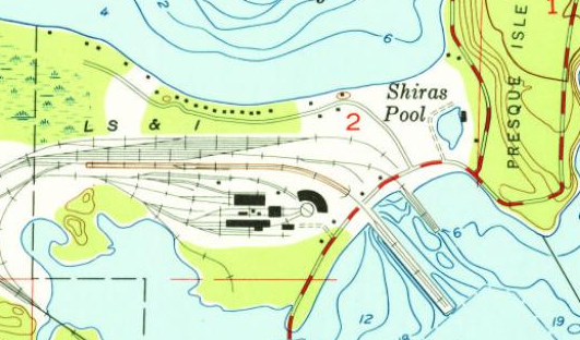
Most of the railyard had been repurposed for a coal-fired power plant. That plant closed in 2019.
1954 Marquette Quad @ 1:24,000
 
Marty Bernard posted
SOO Line Scale at Marquette, MI, no date, Karl Miller photo. The scale is under the tracks in the left foreground. Two of the four rails are a bypass track not connected to the scale so the very heavy locomotive and the cars you didn't want to weigh could bypass the scale. I have no idea what that red vertical pipe is next to the scale house. The scale house has a substantial chimney.  
Steve McEwen commented, "Pipe is a vent for scale pit. Venturi on top allows wind to naturally draw moist air up and away from scale.
Marty Bernard shared

David Schauer posted
One reason I like visiting Marquette in the fall is the color close to the dock. The Hon. James L. Oberstar loading 26,000 tons of Tilden flux pellets for Rouge/Detroit. 10/22/2021
Caleb Hoffarth: Really a great photo with detail. πŸ‘πŸ».Witch brings me to a question. Whats with things sticking out in the water with a specific rectangular pattern? Is it from an old dock or for erosion prevention for bow thrusters?
David Schauer: Caleb Hoffarth Original ore dock pilings.

Most Lakers have a bow thruster. At 3:07, you can see the bow of the Lee A. Tregurtha moving sideways.

(new window, 13:36)


Photo has been moved to Marquette, MI: Aban/Soo/Duluth, South Shore and Atlantic Ore Dock

Photo has been moved to Marquette, MI: Aban/Soo/Duluth, South Shore and Atlantic Ore Dock

MV Saginaw posted   (source)
A view down the walkway showing the counter-weights to the iron ore chutes at LS&I Ore Dock in Marquette, MI. Completed in 1912, this is one of the last of its kind. The main structure is original proving they really don't build 'em like this anymore!
DRE Designs - Great Lakes Marine Products commented on the above post
OMG Adam you seriously need to teach me... yours is so much better than mine!!! You are so good it's annoying but I love it LOL!!!

Michigan Film Photographer Karl Wertanen posted
Good morning!
My day always starts off better with coffee and classic straight deckers.
Herbert C Jackson (1959) finishes up @ LS&I Ore Docks - Marquette
10/2018
Interlake Steamship Company posted four photos with the comment: "Happy #FreighterFriday from our M/V Hon. James L. Oberstar! Enjoy these unique loading pictures from Marquette’s ore dock.
PC: Paul LaMarre III"  (source)
1

2

3

4

Danielle Adams shared her post
LLT’S Michipicoten unloading stone at the upper harbor in Marquette 5-7-19
[This confirms that the hopper is for limestone as well as coal. It also helped me learn about the terminology of upper and lower harbors.]
Danielle Adams shared her post


Mark Andersen posted
LS&I Presque Isle ore dock 9-96.

Mark Andersen posted
Charles M. Beeghly at the LS&I Presque Isle ore dock. Date unknown.

Mark Andersen posted
Courtney Burton at the LS&I Presque Isle ore dock 8-19-95.


1 of 3 photos posted by Thom Skelding
Presque Isle, at Presque Isle! Marquette. May 15th, 2018. Someone will have to fill in why. Pretty sure it wasn't to load ore. I think it needed conveyor work. She arrived on the south side of the dock, and moved to the north side later.
[I include this photo because of the big dome on the left. It is the world's largest wooden dome. "The facility has a diameter of 536 feet. It has the ability to withstand 60 pounds per square foot of snow and 80 mile per hour winds. The Dome's features include a retractable artificial turf carpet, the largest of its kind in the world. When extended, the turf has the ability to accommodate football, soccer (120 x 72 ft. field) and field hockey. Underneath the carpet is a synthetic playing surface that features three basketball/volleyball courts and a 200-meter track. Twelve computerized winches extend the carpet over a cushion of air. It takes 30 minutes to retract the artificial turf carpet and approximately two hours for full set up to be completed." [NMU]]

Thom Skelding posted three photos with the comment: "Presque Isle dock crew loading the Lee Tregurtha today. 7/20/2022"
1

2

3

Danielle Adams posted ten photos with the comment: "Interlake's Hon. James L. Oberstar loading in Marquette 1-2-20" [I'm surprised that boats are still running on Lake Superior in January.  And this is an old freighter because it has its bridge on the bow.]
1

2

3

4

5

6

7

8

9

10

Thom Skelding posted
Kaye Barker, Marquette. 11/29/2022

Thom Skelding posted
Kaye Barker in Marquette this morning. 11/29/2022
Peggy Captain posted 15 photos with the comment: "Great day to be aboard the Block visiting friends. Last load out of Marquette this season. Headed for Toledo and then to Sturgeon Bay for a brief winters nap."
1

2

3

4

5

6

7

8

9

10

11

12

13

14

15
 
Joe Bergeon posted
I was working on one of the stacks at Presque Isle power plant, Marquette, MI, I believe around 2009. Not sure what ship.
Christian Bastian: Looks like the Mesabi Miner.
 

1 of 9 drone photos posted by Greg Carrier
8/1/23 12:40p DJI Air 2s
Today’s “shiptures” include the Joseph L. Block πŸ‡ΊπŸ‡Έ at the Marquette upper harbor ore dock and the Hon. James L. Oberstar πŸ‡ΊπŸ‡Έ waiting patiently a little ways out. Note the jet ski pirates doing a lap around the JLO. The panoramic photo of the JLB was a first attempt at such a picture. Let’s not forget to give a shout out to the tiny dredge with the big job of keeping things moving at the ore dock. For those that have issue with how close I fly some of these photos are cropped which gives the impression of recklessness πŸ˜‰.
James Torgeson shared
Loading Marquette Iron Range ore at the Lake Superior & Ishpeming dock in Marquette, Michigan. These ore pellets came from the TIlden Mine, which like the railroad and ore dock is owned by Cleveland-Cliffs. Once loading is complete, the 721' Joseph L. Block (1976) will head to the Cleveland-Cliffs Indiana Harbor Works.
Tim Grau: Last active property on the Marquette Iron Range.
 
1 of 4 photos and a video posted by Greg Carrier of maintenance work during Winter 2024
James Torgeson shared
When the Soo Locks are closed it's time to do maintenance on the ore docks, and the Lake Superior & Ishpeming Railroad (LS&I) facility in Marquette is no different. The LS&I is one of seven Cleveland-Cliffs subsidiary railroads.

(new window, 1:44)


(new window, 15:45)   Drone footage of a train servicing the dock.  At 11:21, it shows a freighter coming in to pick up some ore. At 13:09 I presume we are seeing the prop wash of the bow thruster.

17:42 video @ 16:10

0:45 timelapse video show the chutes going down, ore pouring out and the chutes going back up.


James Torgeson shared with the comment: "The LS&I is the original of the Cleveland-Cliffs seven subsidiary railroads."
Jason McCullough: What year did it start?
James Torgeson: Jason McCullough 1896.