Roundhouse: (
Satellite)
B&O Depot: (
Satellite, Herald-Mail Media reused not just the depot's land, but a small B&O railyard.)
CVRR = Cumberland Valley RR
 |
Jamie Adams posted
About four years away from the start of CSXT, Chessie System / C&O #7568 is outside the Western Maryland Railway's Hagerstown roundhouse in May 1982. - Kodachrome slide. No photographer listed on slide mount. Collection of J.L. Adams
Jeff Hammaker: CSX start date November 1, 1980.
Jamie Adams: Yes. CSX Corporation was formed on that date in 1980, but actual operations under the entire CSX 'corporate umbrella' didn't take place until July 1, 1986. Up until that time, all the roads that made up CSX were operated as if each were separate from one another. |
 |
Jim Kelling posted
Photo of the Western Maryland in Hagerstown Maryland |
 |
Rick Shilling posted
Undated Western Maryland Railroad Roundhouse,Turntable, Water and Coaling Tower, Hagerstown, Maryland. Roundhouse was built 1939 and demolished 1999. |
 |
Terry B. Carlson commented on Rick's post
Rick, here is a 5-27-1989 Google Earth Image.
Location: 39.6410281,-77.7330292 |
 |
Lora Pfefferkorn posted
Lora Pfefferkorn shared
Sabastian Nussbaum: J1 Potomac 4-8-4 dead center 1 H class consolidation on the right as well as a 1100 class 2-10-0 and a 2-6-6-2 on the left I think for the last. |
 |
| 1948 Baltimore Quad @ 250,000 |
 |
| 1953 Hagerstown Quad @ 24,000 |
 |
Lora Pfefferkorn posted
The demolition of Hagerstown Roundhouse after a 10 year battle to save it failed. City Hall always gets its way despite residents objections.
Lora Pfefferkorn shared
Aaron Sholley: What locomotive is that? Joseph Kline: Aaron Sholley, NYC 0-6-0 6894 Brian Budeit: The NYC engine was moved somewhere for display, cosmetically restored, then hit by a runaway freight car, damaging the tender from the impact. Don't know the engines condition today, seems it received minimal repairs and the tender showed its bent frame. |
 |
Lora Pfefferkorn commented on her post
Here it is in 2019 |
Pennsy Depot
John Miller
posted five images with the comment: "Here is a July 29, 1967 article from the Daily Mail Newspaper regarding the demolition of the Cumberland Valley Railroad train station. Walnut Towers apartments was going to be constructed on that property."
Jim Kelling
shared with the comment: ""Hagerstown Maryland (Cumberland Valley/PRR)
 |
| 1 |
 |
| 2 |
 |
| 3 |
 |
| 4 |
 |
| 5 |
Police Department/Western Maryland Depot
 |
Lora Pfefferkorn posted
Amazing early 1900's image
Dennis DeBruler shared
Jim Kelling: Station was built in 1913 with the tracks in the street on the west side; about 1955 the tracks were moved to the east side and elevated for freight trains (passenger service ended in 1953). Station was visited on the RRSHS tour in 2012. |
Michael Maitland
posted seven photos with the comment: "While driving the highway decided to get off at Hagerstown and look for the old Western Maryland station and facilities. The station was in great shape. The original WM ROW was in the street until moved to an embankment behind the station. The museum was closed but you could see some of the rolling stock outside. Found the steam engine in the park a few miles away, but that was also closed. When younger would read about the yard and the Alco's pushing up Williamsport Hill to the south."
 |
| 1 |
 |
| 2 |
 |
| 3 |
 |
| 4 |
 |
| 5 |
 |
6
|
 |
| 7 |
RE Pearce
posted four photos with the comment: "The current historic station, located in downtown Hagerstown MD, was constructed in 1913 by the Western Maryland Railway as a passenger stop. This 2½-story brick building with a hip roof exemplifies the Commercial Style architecture popular in the early 20th century, featuring functional design elements suited for high-traffic rail hubs. It served as the primary passenger terminal for WM trains traveling between Baltimore, Hagerstown, Thurmont, Owings Mills, and westward to Cumberland and Elkins, West Virginia. In the late 20th century, the building was repurposed and converted into the Hagerstown Police Department headquarters, where it remains in use today."
Ellis Simon: Lot of similarities to WM station in Cumberland.
 |
| 1 |
 |
| 2 |
 |
| 3 |
 |
| 4 |
The museum has a big model railroad layout.
B&O Depot
.jpg) |
Ken Norris posted
[Some comments indicate it was on Summit Avenue and the Dagmar Hotel building is extant.]
Jim Kelling shared
B&O station in Hagerstown Maryland (gone) |
 |
John Miller posted
B & O Train Stations in Maryland and nearby (post one) This is the Hagerstown, Maryland B&O train station located on the corner of Antietam Street and Summit Avenue. This is an artist's rendering of the station and the nearby fire company (far left) and the U.S. Post Office (next to the fire company) as well as the Dagmar Hotel. The Dagmar was a hotel that train patrons utilized when they had a layover. This is one of my favorite train station images. More train stations will be posted (possibly one each day). The post is being shared with the Baltimore and Ohio Railroad group. The rendering would have been from the late 1920s to the late 1940s. After the train station was relocated the property first became a parking lot with an Amoco Station. Later it became the "new" location for the Herald Mail Newspaper building. Today it is the site of Meritus Park. The home of the "Flying Boxcars" minor league baseball team. |
 |
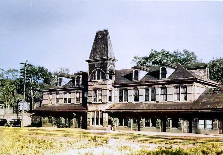
Remember When: Maryland and VA WVA posted
B&O Railroad Station in Hagerstown MD circa 1905!
Glenn Brown shared |
The above topo map indicates that the B&O used to have quite a few tracks in the downtown area. I got this aerial photo to check it out.
Feed Mill
I caught some of the feed trucks in a 2019 view.
Eric M Ziegler
posted three photos with the comment: "Lurgan Sub out of Hagerstown MD, servicing the grain elevator, Jan 1997."
Eric also
posted these photos with the same comment.
 |
| 1 |
 |
2
[I wonder if it is a load of soybean meal.] |
 |
| 3 |


.png)

.png)


.jpg)


