Mills: (
Satellite, the steel works were on the south side, the wire works were in the middle and the zinc works were on the north side.)
It seems that about every bend along the Monongahela River had a steel mill on it.
"The Union Steel Company started a rod mill in the new town of Donora in 1901. It became the American Steel and Wire Works in 1908 and closed permanently in 1962." [
psu]
 |
Vonie Long posted
American Steel and Wire Company Donora, PA Fort Pitt Publishing postcard |
Frank Jacobs III
posted two images with the comment: "Donora Pa."
 |
| 1 |
 |
| 2 |
 |
Frank Jacobs III posted
Donora, Pa.
Michael Maitland: Interesting to see. Have read that Donora had specialty mills like galvanizing and zinc related, but not much on the actual details of this area. |
 |
Frank Jacobs III posted
American Steel and Wire, Donora, Pa. 1911.
Thomas Crespo: 13 oh furnaces, 2 blast furnaces. For a while they had 2 Bessemer converters. |
 |
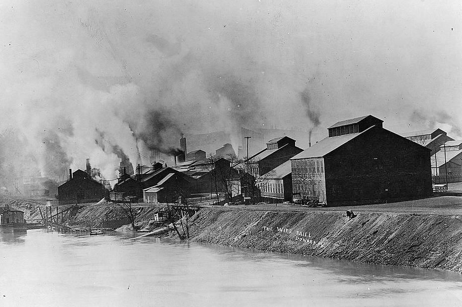
SmithsonianMag, Library of Congress
"The Donora wire mill (which later became part of the American Steel & Wire Company) on the banks of the Monongahela River in 1910." |
 |
| RiversOfSteel, Donoral Historical Society, this webpage has several more historical photos of Donora |
 |
The Mon Valley Photo Works posted
-Donora Zinc Works- The site of US Steel's former Donora Zinc Works. The building in the center of the frame was the plant office. In late October of 1948, smog enveloped this area of the Mon Valley for several days due to an atmospheric inversion trapping the dangerous exhaust gases and smoke from the zinc works. The smog killed 20 people and sickened many more, and is considered a catalyzing moment for starting the clean air movement in the United States, ultimately leading to the Clean Air Act of 1963. Presently, the Zinc Works buildings are occupied by Dyno Nobel, an explosives manufacturer. |
 |
Anthony Cominotti posted
Rick Rowlands: This is the installation of what I think was the last steam driven rolling mill installed in the US at the AS&W Donora, PA works. We are looking at the crankshaft and main drum of the engine. You can see one of the Corliss cylinders on the right. This mill was rope driven with each train of rolls driven by some of the ropes off of the main drum. |
Anthony Cominotti
posted seven photos.
 |
| 1 |
 |
| 2 |
 |
| 3 |
 |
| 4 |
 |
| 5 |
 |
| 6 |
 |
| 7 |
This photo was taken during daylight hours when nearby towns had an abundance of sunlight. That helps illustrate how bad the smog caused by a temperature inversion had become.
 |
SmithsonianMag
The Donora Smog of 1948 began on October 27 and lasted until October 31, when rain cleared the combined smoke, fog and pollution that had become trapped over the town. Bettmann / Contributor
"On Saturday October 30, around 2 a.m., the first death occurred. Within days, 19 more people from Donora and Webster were dead....The federal agency sent 25 investigators to Donora and Webster, where they took health surveys from residents, inspected crops and livestock, measured different sources of air pollution, and monitored wind speed and meteorological conditions. They found that more than 5,000 of the 14,000 locals had experienced symptoms ranging from moderate to severe, and that the American Steel & Wire Plant and the Donora Zinc Works emitted a combination of poisonous gases, heavy metals and fine particulate matter. “If you looked at the X-rays of their lungs, they looked like the survivors of poison gas warfare,” Davis says." |
 |
DonoraHistoricalSociety_1948-smog
"The killer fog, and others that predated it back to 1905, introduced America to a new term: 'smog' - a combination of industrial pollution or smoke and naturally occurring fog. The 1948 Donora Smog made the world aware of the dangers of unchecked pollution. The tragic and heroic events of that October weekend helped shape the environmental movement that was to follow." |
A newsreel about the killer smog.
These are 15 of the 126 photos from the
Bruce Drisbach-American Steel & Wire Company Photographs at the University of Pittsburgh. They cover the construction of the homes and mills from 1915 to 1917.
.jpg) |
200102.019.DR
View of the American Steel & Wire Company from the river. |
I presume that the following is the above equipment in operation. I wonder what it does.
The Pittsburgh and West Virginia (P&WV) railroad was on the river side and the Pennsy was on the town side. The Pittsburgh and Lake Erie was on the other side of the river.
 |
Dennis DeBruler commented on Vonie's post
1954 Donora Quadrangle @ 1:24,000
|
The Norfolk & Western railroad got the P&WV in 1964.
 |
| 1954/84 Donora Quad @ 24,000 |
The N&W route was abandoned. I haven't figured out how to get Class I names from this map. And the 1993 topo map does not label the railroads! Since the P&LE merged into CSX in 1993, I presume that NS got this part of Pennsy.
Zinc Works
 |
Phil Jad posted
US Steel Donora Pa Zink Works [According to some comments, the major part shut down in the late 1950s, and it was completely gone by 1968. And US Steel retired their blast furnaces in Clairton and McKeesport in the 1960s.] |
 |
Phil Jad posted
US Steel Donora Zink Works Dean Dodszuweit: The 1948 Donora smog killed 20 people and caused respiratory problems for 6,000 of the 14,000 people living in Donora. That doesn't include the unreported deaths of plant workers. Pete Steffey: This was the source of the killer smog . The smoke from the Zinc Smelter combined with fog from the Monongahela River and settled in the valley . A rare inversion held the poisonous air in place long enough to kill. |
 |
Phil Jad posted
US Steel Donors Zink Works Ken Mueller: Scott Gracie the emissions from Donora burnt the hillside across from the facility turning vegetation brown which led to the creation of the EPA. My understanding anyway. Worked for 7 years down river from the plant early 90s in Monongahela. KC Puglisi: Some say , the reason they shut it down was to avoid lawsuits. Ralph Cappella: KC Puglisi I believe one of the reasons was (even back in the 60's) they had "environmental issues".... From what I read, the area was so badly engulfed in smog that it left a "sticky residue on everything it touched"... |
 |
Phil Jad posted
Andrew Stewart: Pretty much got closed because the pollution released in 1948 contributed to a few fatalities in the community. Patrick Anderson: Andrew Stewart a few???? 20 is considered a few? 50 more died with a few months of the incident and an estimated 6000 ended up suffering from respiratory diseases......... |


.jpg)
.jpg)
.jpg)
.jpg)
.jpg)
.jpg)
.jpg)
.jpg)
.jpg)
.jpg)
.jpg)
.jpg)
.jpg)
.jpg)


