Wednesday, October 30, 2024

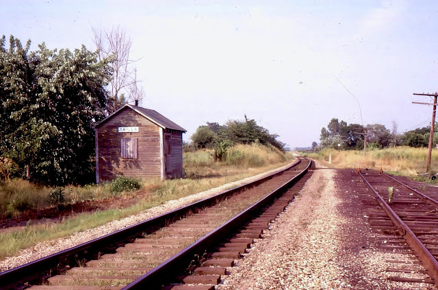
Trilla, IL: Lost Depot on EIRC/NKP/Cloverleaf Route

(Satellite, a very unconfident guess.)

EIRC = Eastern Illinois Railroad Company

Andy Zukowski posted
Nickel Plate Railroad Depot in Trilla, Illinois. 1966

If you look closely, one can see a slight curve in the tracks between State Street and the bridge. The depot photo must have been taken with a telephoto lens because the curve appears to bend more in the photo.
1960 Aerial Photo from ILHAP

Fortunately, Illinois has been uploading additional aerial photos because the late 1930's aerial was very confusing. For one, the shadow of the long looking building in the southeast quadrant of State Street and the tracks doesn't make sense.
1939 Aerial Photo from ILHAP

There is a long building there today.
Satellite

No street view driver has done the streets of this town, but I did find this view of the long building. Why would you build a new building with that roofline?
Street View, Aug 2023

It is a company that builds seed cleaning equipment and other agricultural machinery.
CommodityTraders


Frankfort, OH: B&O West Junction (BK) Tower: B&O vs. B&O/CHD

(Satellite, the photos indicate it was on the south side of the tracks.)

CHD = Cincinnati, Hamilton & Dayton

Darren Reynolds posted four photos with the comment: "Baltimore and Ohio Railroads    "BK" tower(West Jct.)    Near Chillcothe, Ohio."
Jeff Steinbrook: This is Musselman Station Rd. just east of Frankfort, Ohio it is where the lines from Cincinnati, Ohio and Dayton lines connected, they controlled passing trains here also, to where they could switch off trains onto the line which run up and through, North Fork and the Papermill onto Southern Ave. The old switchman's building sits on Cooks Hill Rd. someone paid to have it moved and put there.
Brandon Willis: Where exactly was BK tower?
1
A westbound passing "BK" tower on the St.louis main on July 8,1972
Photo by: David P. Oroszi

2
The Caboose from a Eastbound is passing by "BK" tower On July 8,1972
Photo by: David P. Oroszi

3
Looking West at "BK" tower Dec.1980

4
Looking West a B&O train is ready to pass the West Jct.
Switch at "BK" tower on July 27,1983
Photo by: Frank Garon Collection

Dennis DeBruler commented on Brandon's question
https://maps.app.goo.gl/zNPWPTZ1XUStACPC7 Even OH-100 is now abandoned across Paint Creek. The trail uses the Cincinnati, Hamilton & Dayton (CHD) route to the west to Frankfort and the B&O route to the east. Ironically, there is still a B&O bridge in the upper-left corner.

1961/62 Bourneville Quad @ 24,000

Apr 22, 1960 @ 24,000; AR1VAAX00050083

Digitally Zoomed

Minneapolis, MN: C&NW/M&StL and GN Cedar Lake Railyards

(Satellite)

Greg Smith posted
I made a number of air trips over the Twin Cities in the 1970's getting photos of all the railyards. We could rent a plane and pilot for about $25 per hour. This is looking west on Highway 12 (I-394 now) at Penn Av. Tha'ts the CNW/M&StL Cedar Lake shops, and the GN Cedar Lake yard in the middle. Some of the GN guys told me the GN yard was to assist in reefer cars with apples arriving from the west.
Tom Domres: We heard that this was a busy spot back in the day. Apparently ice would be harvested from the lakes and stored in ice bunkers. That ice would be added to reefers holding produce from the West.
Anthony Wood: Boy I'm so glad this was replaced by bike trails people don't use, single track main, light rail that's running in the wrong spot, and a service road people use as a trail instead.
[There are several more comments about the light rail project.]
Mike Boudreau shared
Started out as a laborer in this shop for six months then I got chance to move to being a fireman.

1952/54 Minneapolis South Quad @ 24,000

The M&StL had another yard to the northwest. I don't know if that was also Cedar Lake or if it had its own name.
1952/54 Minneapolis South Quad @ 24,000

I got an old aerial photo of the shops to confirm it had a transfer table.
May 8, 1947 @ 17,000; AR1DV0000040047

Tuesday, October 29, 2024

Coal Center, PA: Vesta Coal Mine #4

(Satellite)

Jackson-Township historical preservation posted
Tipple at Vesta Mine No. 4 near the town of Fayette City, Fayette County around 1930.
John Matty: Vesta 4 came out between California and Coal Center PA. Washington County side of the river.

Dennis DeBruler commented on the above post
June 18, 1952 aerial photo. Harrison Road is along the left side.
[Facebook flagged this comment as a violation of their Community Standard, so I deleted it so that they wouldn't put me in the jailhouse. This has to be an example of AI gone bad.]
[AR1UG0000020032]

Digitally Zoomed

We can still see part of the embankment on which the conveyor belt ran.
Satellite


Ohlman, IL: Lost/Big Four & C&EI Union Station

(Satellite)

Andy Zukowski posted
Union Railroad Train Station Depot at Ohlman, Illinois. 1908
Bill Edrington: Owned by the Big Four; C&EI had trackage rights from Pana to Granite City and its passenger trains made conditional stops at Ohlman at that time.
Dennis DeBruler: Bill Edrington Thanks, I wondered why it was a union station.
Bill Edrington: Dennis DeBruler - Technically I guess it was, but I suspect that if a stranger had asked somebody in Ohlman where "Union Station" was, they probably would have said "St. Louis."
Richard Fiedler shared
Keith Cearlock: Can you share please?
Dennis DeBruler: Keith Cearlock Private groups can't share. But if you click the photo you get to Andy's post, and that post can be shared.
Steven Hooker shared
Colin Harding: According to my 1940 Official Guide on the C&EI and Nickel Plate.
Dennis DeBruler: Colin Harding If you click the photo, you can access the comment by Bill Edrington. He and some maps indicate the tracks were owned by Big Four and C&EI shared the tracks and station. I wonder how the Nickel Plate was involved.

Dennis DeBruler commented on Andy's post
I'm glad I saw Depot Street because I had originally guessed a rectangle on the town side of the tracks. But when I looked again on this 1939 aerial, I could clearly see the platform of the depot. And Andy's photo shows there were no buildings behind the depot. https://maps.app.goo.gl/9j1JZEhJi1GUSVnR6

Wadsworth, IL: Lost/Milwaukee Depot

(Satellite)

Andy Zukowski posted
Milwaukee Road Depot in Wadsworth, Illinois.  1969

Dennis DeBruler commented on Andy's post
Another bedroom community for which it is hard to determine where the town started. It was along Wadsworth Road to the east of the tracks. 1960/62 Wadsworth Quad @ 24,000

Dennis DeBruler commented on Andy's post
The rectangle in the northwest quadrant of the tracks and Wadsworth Road on the topo map does not agree with Andy's photo, so I got the 1939 aerial photo. It appears it was about a block north of Wadsworth Road on the east side of the tracks.

The town still has a cute feed store. Note the old grain bin on the right side of the photo and the Purina checkerboard logo on the left side of the building. 
Street View, Jun 2024

I doubt if they grind any feed here anymore.
Photo, Nov 2023

Monday, October 28, 2024

Amsterdam, NY: Concrete Plant/Adirondack Light and Power

(Satellite)

Street View, Jul 2022

James Bailey posted
This was shot through a dirty, scratched-up window in a fast moving train a couple days ago, but it's worthy of a share none the less.
This is a defunct coal-burning power plant built in the 1920's on the south bank of the Mohawk River (AKA the Erie Canal) just east of Amsterdam, NY.
"The architects were McKee, Kim and White (edit: should be "McKim, Mead & White"), the people who designed the  original Pennsylvania Station and Madison Square Garden in New York City."
To say "They don't build them like that anymore!" is an understatement.  What a beautiful building!  Utilitarian does NOT have to mean "cheap and ugly".

The current company makes concrete blocks and...
Cranesville_block

...precast products.
Cranesville_precast

Carol Flickr, cropped
Old Adirondack Power and Light Plant
This is the old Adirondack Power and Light Plant. This abandoned steam electric plant is now used for storage by the Cranesville Block Co. There are trucks and cement blocks all around inside the fenced in yard close to the plant. This old parking lot right in the front is quite empty these days. This old steam electric plant is located on the south side of the Mohawk River. ( It is thought that Enlarged Erie Canal Lock 26, Phillips Lock, would have been located opposite the western corner of this steam electric plant, near the railroad tracks making it about 1/4 mile east of Lock 27. There is, however, no sign of it today. It was either demolished or buried. Old Lock 26 would have been a double chamber lock, lengthened at the foot on the berme side with an 8.010 lift west. )This shot was taken from 5S near Pattersonville. It is also near Lock 10 of the Erie Barge Canal.

nysarchivetrust
"Medusa white cement was an innovation of the Sandusky Portland Cement Company of Ohio patented in 1903 for its pure white color and resistance to staining."

The backside obviously did not use the special concrete mix, and it makes you appreciate the effectiveness of that mix.
Street View, Aug 2021

ArtsAndCluture, miSci- Museum of Innovation & Science
1927

The Mohawk Valley Through the Lens posted
Former Adirondack Power & Light
1920s former coal-burning power plant built on the Mohawk River/Barge Canal in the town of Florida, Rt.5s, just east of Amsterdam, NY. It was purchased by Cranesville Block Company in 1964 and is currently used for manufacturing and storage of stone products.
Captured: April 12, 2018

Rob Martinez commented on the above post
Travel this road a lot. Love the building. And have taken many pics of it. Would like to go inside someday 🙂

Granville, IL: NYC and Milwaukee Union Depot

(Satellite)

Andy Zukowski posted
Union Depot in Granville, Illinois. C.1910
Robert Weber: Thanks Andy. Never seen this before. Anyone have any idea where it was located? I know in the “Y”.
Kam Miller: Robert Weber, I am guessing here, but I would say at the end of Church Street on the portion of the street that dead ends.
Robert Chitwood: Robert Weber 1911 atlas shows the depot on McCoy Street on the east side, so the photographer is standing on McCoy then.
Steven Hooker shared

Dennis DeBruler commented on Kam's comment
I think it was a block further west, https://maps.app.goo.gl/sWEzqguJvysDKU3d7. Given the curve in the photo, I think we are looking east and the track on the far left is a house track. 1939 Aerial Photo

1913/48 La Salle Quad @ 62,500

Mascoutah, IL: Lost/L&N Depot

Original Location: (Satellite, L and N Ave. was built on the L&N RoW.)
Current Location: (Satellite)

Andy Zukowski posted
Louisville & Nashville Railroad Depot at Mascoutah, Illinois. C.1910
Richard Fiedler shared

Andy Zukowski posted
Louisville & Nashville Railroad Depot at Mascoutah, Illinois. 1960
Steven Hooker shared
The Depot has since been moved to the City Park and still exists today.
 
Dennis DeBruler commented on Steven's share
They have also preserved a caboose. https://maps.app.goo.gl/qyUwo4iki8jzoiu6A
 
Andy Zukowski posted
L&N Railroad Depot in Mascoutah, Illinois (1965)
Michael Donohue: And well preserved in the park. They were still unloading farm implements in the mud 70's.
Thank you for posting, anymore Mascoutah/Renchler pics?
Dennis DeBruler: Michael Donohue Andy Zukowski posted a couple more yesterday. I have noted them as well: https://towns-and-nature.blogspot.com/.../mascoutah-il...
Jacob Hortenstine shared
Richard Fiedler shared

Bill Balint commented on Andy's post
The L&N depot relocated to Scheeve Park in Mascoutah, IL. Not my picture.

1940 Aerial Photo from ILHAP

1954/59 Mascoutah Quad @ 24,000

The local grain elevator has a rather unique design that based on a couple of long conveyor belts.
Street View, Oct 2023

The leg on the left in the above view feeds a conveyor belt, but the one to the right of it feeds a couple of more bins and a loadout.
Street View, Oct 2023