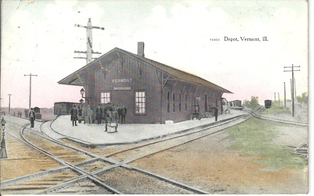
 |
| Andy Zukowski posted CB&Q Railroad Depot in Vermont, Illinois. 1908 Richard Fiedler shared |
 |
| John Carson posted ANOTHER VINTAGE SOCIAL MEDIA FIND: Earlier Post Card of the Vermont Illinois CB&Q Depot! This one circa December 27, 1907! C.T. American Art Post Card which they color enhanced a black and white photograph. Shows the Order Board and and a group of gentlemen going places! I believe the view is South Southwest. EnJoY! JCC [His post also includes the backside of the postcard if you want to see an example of cursive handwriting, which is also now history.] John Carson shared |
This shows that the artist added more than color. He cleared it up and removed the pole that was in the foreground.
 |
| Roger Kujawa posted Vermont Illinois real photo postcard C. B & Q Railroad Depot posted 1907. |
A better exposure.
 |
| Andy Zukowski posted Chicago, Burlington & Quincy Railroad (C.B&Q) Depot in Vermont, Illinois. DEC 9, 1907 Thomas Whitt shared |
And another exposure.
 |
| Andy Zukowski posted CB&Q Railroad Depot in Vermont, Illinois. 1907 Marvin McGill Jr.: Don't recall the cross over what railroad was that? Richard Fiedler shared |
To better understand the two CB&Q routes, I consulted a topo map. Vermont is at the two crossed black lines to the left of center.
 |
| 1953 Burlington Quad @ 1:250,000 |
I used a 1928 RR Atlas to confirm that the southwest route never did go beyond Rushville. The southwestern route is now abandoned, but the other three routes still exist. In fact, the north/south route still goes all they way down to the Metropolis Bridge over the Ohio River that CB&Q help build.
 |
| Andy Zukowski posted Chicago, Burlington & Quincy Railroad depot at Vermont, Illinois. Three men stand outside the depot. A water tank dwarfs the depot building. Paul D. French: The CB&Q bought the Breadstown line in the first decade of the 20th Century. That line went north at least as far as Sterling, Illinois. From there it went through Denrock, Barstow, Rio, Alexis, Monmouth, and Bushnell. The track from Galesburg to Rio was built later. It became part of the Galesburg to Savanna line. If I remember right, five separate track segments became that piece of railroad. When I hired out the mileposts changed five times between Galesburg and Savanna. The mileposts have since been changed to be continuously numbered. Stan L. Maddox: The concrete footings for the water tower are still there. Thomas Whitt shared |
 |
| Larry Candilas commented on Andy's post Where the north-south CB&Q Beardstown line crossed the CB&Q Buda-Rushville branch. Looks like the water tower may have still been there in this late 1930s aerial. |
 |
| Dennis DeBruler commented on Andy's post When I dropped a pin on the depot's location on a satellite map, I was surprised that the depot was on the line between the northeast and southwest routes. The aerial photo shows no connection. And this topo map confirms that they were not connected. I'm disappointed by the inaccuracy of the location of the depot on the map. It should have been a rectangle and closer to the north/south route. 1948 Vermont Quad @ 24,000 Update: but the photo shows that there used to be a connection between the two diagonal routes because there is a diamond in the photo. |
 |
| Dennis DeBruler commented on Marvin's comment That was also CB&Q. https://collections.carli.illinois.edu/digital/collection/knx_rail/id/298 |
 |
| Andy Zukowski posted CB&Q Railroad Depot in Vermont, Illinois Richard Fiedler shared |
A different exposure and photo credit
 |
| Andy Zukowski posted The Chicago, Burlington and Quincy Railroad Depot in Vermont, Illinois. C1910 Photo by C.R. Childs Larry Candilas: Most likely looking south toward Beardstown. John Burt: Larry Candilas Probably, because I believe the depot was on the west side of the tracks. |
 |
| Andy Zukowski posted CB&Q Railroad Depot in Vermont, Illinois. 1908 |
No comments:
Post a Comment