Roundhouse: (
Satellite, once again, the filled in pits mark the foundation remnant.)
Railyard: (
Satellite, only a fraction of the original tracks is left.)
Depot: (
Satellite, according to Thomas' map screenshot below and the aerial photo. The Madison Street (Nickel) Bridge no longer exists.)
Freight House: (
Satellite, the office part was east of the "Million Dollar" Bridge, and the baggage handling part was under the bridge.)
Tower: (
Satellite, there used to be a lot more tracks here. This is one of two guesses.)
 |
Donald Kerns posted
The old roundhouse that once stood in Fairmont West Virginia.
Linda Rutherford: Evan Cole The round house pictured is the second one or "new Roundhouse" constructed in the early to mid-1950's. I think it was built to accommodate the steam engine era and those larger locomotives. The entire B&O Fairmont (Bellview) Yard operation was gone and all its structures demolished in approx 25 - 30 years after the "new" roundhouse was constructed. In the early to mid- 1980's, if I remember correctly.
I grew up there, playing in the woods and along the tracks, climbing on cars in the siding, and walking across the trestle over the Monongahela River. I never dreamed the bustling yard would ever be gone but watched the demolition in adulthood. Candy and pop, and occasionally a hot dog from the Beanery. Paternal grandfather was a Conductor, and would lift us up into the caboose when the train stopped to switch into the yard and we'd ride the last feet - what a thrill! Maternal grandfather was a machinist. Paternal Uncle rose to be General Chairman of the United Transportation Union. Another Uncle was a Brakeman and killed at Barrackville while working switching empties into the mine.
Most of the neighborhood men worked there, too. Fairmont's long history with the B&O.
Frank Gozel: Fairmont - Nickel Bridge?
Linda Rutherford: The Nickel Bridge is further up river in Fairmont closer to WD Tower.
|
The B&O was on both sides of the river. It is not unusual to have tracks on both sides of a river, but normally they are owned by different railroads.
 |
| 1958 Fairmont West and East Quads @ 24,000 |
 |
Dennis DeBruler commented on Linda's reply about the WD Tower.
Is this the WD Tower? I see that a branch up Buffalo Creek to some coal mines used to leave the mainline here.
https://maps.app.goo.gl/uJkWemDcBeirTkX59
[Update: or was this the tower's location?] |
Dave Kuntz Drone Photos
posted four photos with the comment: "Spread out like a giant fan, the B&O roundhouse foundations in Fairmont, WV. Notably there are still some rails in the ground."
Dave Kuntz Drone Photos
shared |
| 1 |
 |
| 2 |
 |
| 3 |
 |
| 4 |
Thomas S Miller posted four photos with the comment: "Fairmont WV."
 |
| 1 |
 |
| 2 |
 |
| 3 |
 |
| 4 |
These are the piers of the Nickel Bridge. "Nickel" was the name because the toll was a nickel.
 |
Joseph topping posted
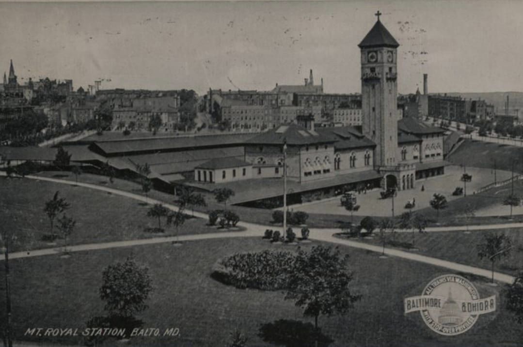
The Baltimore & Ohio Railroad passenger station in Fairmont, West Virginia, once stood prominently along the Monongahela River at the foot of the Third Street Bridge, serving as a vital transportation hub for the region through the late 19th and early 20th centuries. Opened in 1903, the brick depot replaced earlier wooden structures and quickly became central to Fairmont’s booming coal and glass industries, facilitating both passenger travel and freight shipments. The depot was eventually closed and demolished in the mid-20th century.
Eric Hansmann: There was quite a bit squeezed into the narrow area along the river here. The freight house is rarely noted, but easy to spot in this colorized postcard image. [The building on the left with a two-story part.] It had two parallel tracks for loading and unloading cars. There were also two running tracks for the line along the river here. Amber Phillips Smolski: The 3rd St Bridge is 6+ blocks upstream (to the left or south) from the depot, and wasn't built until the late 70's after the depot was torn down. The steel bridge in this photo was known as the "low-level" or "nickel" bridge and replaced the original suspension bridge using the same abutments. It connected the east side of the river (originally known as Palatine) to Quincy St in the downtown area. (1st St is the first cross street on Fairmont Ave outside of the of downtown area, continuing south to 14th St before it crosses the West Fork River just above where it meets the Tygart to form the Mon River. The Mon flows north to Pittsburgh.) This photo also shows •Watson Hotel, red brick with spires above the depot, •Watson Building, the tall gray one which houses a bank and many prominent offices, and •the newer Skinner's Tavern in the building just above and slightly left of the depot, a popular spot for travelers. The Watson's were barons in Fairmont's early 1900s coal and business history, with homes on Fairmont Ave (High Gate Mansion and Fairmont Farms). |
Thomas S Miller
posted 16 photos with the comment: "B&O, Fairmont,WV. A lost legacy."
Dick Spatafore: WOW,great pictures. I worked in the yard several years there on the track. A,B and C yards were the coal tracks. I think the scene by the bridge is nearing Gaston Jct. where the MR sub and the Fairmont Sub split with it going to Grafton and the MR going to Clarksburg via Shinnston. FDR stopped there once during his campaign. Our office was in the Roundhouse. The Fairmont is part of the original Old Main Line from Baltimore to the Ohio River thru Mannington WV.
 |
1
Thomas S Miller: Passenger station The top 4 windows were in my grandfathers office. |
 |
2
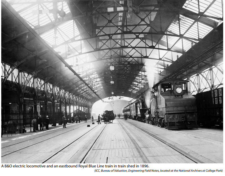
WVNC Rails posted
Fairmont, WV is located in the former heavy industrial belt that extended south from Pittsburgh into West Virginia to Clarksburg. At its peak, it was a center of the northern coal region in the state in addition to heavy manufacturing such as steel and glass. The B&O maintained a powerful presence n the city. Home to a large yard, facilities also included a turntable and roundhouse and a junction for diverging routes. WD Tower was located at the yard throat and also controlled movements on the FM&P (B&O line through Morgantown into Pennsylvania) and the Old Mainline between Fairmont and Wheeling via Moundsville. When this 1948 photo was taken, industry and mining were thriving with Fairmont teeming in rail traffic. Operators at WD Tower earned their pay. Image courtesy Doddridge County Historical Society Thomas S Miller: My grandfather was coal traffic supervisor for the Fairmont district for 20+ years. At one time the busiest. |
 |
3
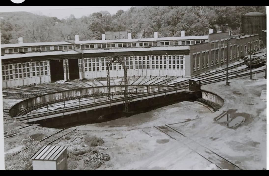
Bruce Elliott Railroad Slides Inc/Pocahontas Co. Society of Model Engineers: Taken from the second coal tower. This is before the roundhouse was rebuilt in the early '50s.. |
 |
4
Thomas S Miller: Passenger station. “Million Dollar Bridge “ in the background. Nickel bridge on the left. [ bridges] |
 |
| 5 |
 |
6
Bruce Elliott Railroad Slides Inc/Pocahontas Co. Society of Model Engineers: The largest coal marshaling yard on the B&O for seven decades ! |
 |
7
Bruce Elliott Railroad Slides Inc/Pocahontas Co. Society of Model Engineers: The original roundhouse with Buffalo Creek in the foreground. |
 |
8
Bruce Elliott Railroad Slides Inc/Pocahontas Co. Society of Model Engineers: The freight house is in the center behind the string of box cars. Passenger station is at the right.
|
 |
| 9 |
 |
10
Bruce Elliott Railroad Slides Inc/Pocahontas Co. Society of Model Engineers: This is the new roundhouse, completed in 1954.
Ron Baker: Thomas S Miller. Location of this? |
 |
| Thomas S Miller commented on Ron's comment |


%20Back%20in%20Chicago.%20We...%20-%20Chicago%20&%20North%20Western%20Historical%20Society%20_%20Face.png)