Thursday, July 31, 2025

Farlin, IA: Lost/Milwaukee Depot

(Satellite)

Christopher Robert posted
Farlin, Iowa.
I don't ever recall seeing the depot or the tracks. The grain elevator was burned down about 10 years ago for FD training.

Paul Hurst commented on Christopher's post
There is nothing there now. NO station, elevator or tracks. Not much to Farlin either. From Google Earth View:

I got two aerial because the old one is low-resolution and the depot might be gone by 1973.
May 22, 1950 @ 70,000; ARA000700292861

I'm surprised the rather modern grain elevator northwest of the depot has also disappeared.
Jul 11, 1973 @ 24,000; AR1VDCD00030064

1962/64 Farlin Quad @ 62,500

Barstow, IL: Lost/CB&Q Depot

(Satellite, BNSF still has a couple of buildings in the wye.)

Retro Quad Cities posted three photos with the comment: "Barstow, Illinois."
Miles W. Rich: It is still the junction of the QC Joint line to the Crescent Bridge and the main line from Savannah to Galesburg.
Paul Schmidt: Worked for the BN there when the little yard was always full of John Deere and International Harvester products on flat cars bound for all over the world.
Fans of Rock Island Lines shared with the comment: "Was a former C.B.Q. Station. Maybe a mile and a half off Silvis yard.  The tracks leading to their rock river crossing are elevated on concrete box approx 12ft high, it runs over a half mile that way. Once you get onto wall it feels like your on a bridge overpass. I've fished off the bridge piers back in the day. Back when to jump off wall into river bottom or rather the flood plain, wasn't a big deal. It was a double track across river heading towards Colona. The cross track pic i have shows Colona and the 2 mains looking towards Carbon Cliff, with a C.B.Q. train having g just crossed the diamond. That train was headed here, next stop Barstow."
1

2

3

This topo map accurately marks that the depot was in the south leg of the wye. 
1950/50 Port Byron Quad @ 24,000

1938 Aerial Photo from ILHAP

1902

Ontonagon, MI: Milwaukee Roundhouse, Water Tower & Coaling Dock and 1853+1866-1964 Lighthouse

Railyard: (Satellite, the northern half of the "island" and the area south of Chippewa Street used to be covered with tracks.)
Lighthouse: (Satellite)

Greg Bunce posted
Here's the St. Paul roundhouse in Ontonagon, Michigan in 1909. There is a gallows armstrong turntable in front of the house.  The coal dock is to the right behind the caboose. Notice the cattle grazing in the right of way with one standing under the water
tank. This is from a post card that I have edited to remove the yellowing.
This photo is from the David V. Tinder Collection of Michigan Photography at the University of Michigan Library.

Jim Koski commented on Greg's post
Used "curves" for more blacks.....

1955/56 Ontonagon Quad @ 62,500

Jun 28, 1938 @ 20,000; AR1A00000050003

Lighthouse


Jim Vining, Jul 2021

Bailey Geist, Oct 2022

Cheryl Learmont, Aug 2024

Wednesday, July 30, 2025

St. Lawrence, SD: "The Last Cribbed Elevator Structure Built in the US."

(Satellite)

Wesley Peters posted four photos with the comment:
The Last Cribbed Elevator Structure Built in the US.
St Lawrence, Hand County, SD.
St. Lawrence Farmers Elevator. False-front headhouse built in 1988. No bushel capacity mentioned. Annex built in 1992. No bushel capacity mentioned. Both by Hogenson Construction Co.
This annex was, to my knowledge, the last cribbed elevator structure to be erected in the US. The second to last cribbed elevator structure built is an annex that was completed in 1991 at Milton, Cavalier County, ND.
Photographed on 7/13/2025.
Photos courtesy of Wesley Peters.
1

2

3

4

There are storage bins all over town.
Satellite

The railroad was the C&NW.
1967/68 Miller Quad @ 24,000

Waterbury, CT: 1909 Metro-North/NYNH&H Depot

(Satellite)

Street  View, Nov 2020

Street View, Aug 2017

safe_image for $20M Waterbury train station renovation will begin in September, DOT says

This topo map accurately marks the location of the station.
1955/57 Waterbury Quad @ 24,000

Waterbury is in the upper-right corner of this excerpt of the commuter service that it is part of.
Map

Muskegon, MI: 1895 Visitors Bureau/Union (PM, GTW + Pennsy) Station and PM Caboose

(Satellite)

Street View, Apr 2024

Street View, Jul 2025

Durand Union Station-Michigan Railroad History Museum posted two photos with the comment:
Today’s featured depot is the Union Depot in Muskegon 🚂
Muskegon’s Union Depot opened in 1895 and served three railroads: the Chicago & West Michigan, the Muskegon, Grand Rapids & Indiana, and the Toledo, Saginaw & Muskegon. Local businessmen had worked hard to bring the station to life—offering financial incentives to the railroads and securing a prime location along Muskegon Lake, near the Central Wharf.
This depot is a stunning example of Richardsonian Romanesque architecture. It was built from red brick and variegated Jacobsville sandstone, and originally topped with a slate-covered hipped roof. The building’s interior was finished in oak and black ash woodwork, steel-paneled ceilings, and ornate fireplaces.
Over the years, several national political figures stopped here during whistle-stop campaigns—including William Jennings Bryan in 1896, Richard Nixon in 1952, and President Harry Truman campaigning for Adlai Stevenson that same year.
Union Depot served as Muskegon’s main rail terminal for decades, but in the 1990s all rail service to this station ceased. The depot was later donated to Muskegon County in 1992 and fully restored.
Today, the beautifully preserved building serves as the Muskegon County Convention and Visitors Bureau.
Sources:
Eckert, Kathryn Bishop. “Muskegon Union Depot”. SAH Archipedia. sah-archipedia.org/buildings/MI-01-MU8 Accessed 25 July 2025.
Sonnenberg, Mike. “The Union Depot in Muskegon”. Lost in Michigan. 04 March 2022. lostinmichigan.net/the-union-depot-in-muskegon/.
1

2

I could not find an older topo map that showed the railroad names in the above description. But I know that the GR&I was bought by the Pennsy. And given the name Chicago & West Michigan, it must have become PM because they had the route from Chicago up along the lake shore. So, Toledo, Saginaw & Muskegon must have become the GTW.
1930/30 Lake Harbor Quad @ 48,000 and 1930/60 Muskegon Quad @ 62,500

Westfield, IL: Lost/Danville, Olney & Ohio River Depot

(Satellite, if my guess is correct, only the foundation slab was left by 1939.)

Michael J. Samuel posted
There is little to no evidence that the Cincinnati, Hamilton and Dayton RR ran along today's Route 49 in Coles and Clark Counties in Illinois.

Dennis DeBruler commented on Michael's post
I also think of Cincinnati, Hamilton and Dayton as a railroad in southwestern Ohio that was absorbed by the B&O. The 2005 SPV Map labels this route as DOOR: Danville, Olney & Ohio River. It was originally a 3' gauge railroad. It must have been abandoned during the depression because it does not show up on the oldest topo map that I could find, 1936. The slant of the south end of Archer Street, https://maps.app.goo.gl/mdYdRa1nghkmx8sHA, and the tree line to the west of Archer are some traces of the railroad. 1939 Aerial Photo

The town's grain elevator is rather big. Especially since it hasn't had rail service for almost a century.
Satellite

Hazen, AR: 1915 Rock Island Depot and Caboose

(Satellite)

Street View, Sep 2013

I.e. Xam posted
Hazen, CRI&P-1915   Picture taken in 2019.

The grain elevator in the right background of the above street view is Riceland Foods.
Satellite

Street View, Nov 2024

A lot of rice must be grown around here.
Riceland

The SSW (Cotton Belt) route is marked as abandoned in the 1941 map. According to the 2004 SPV Map, Rock Island abandoned their east/west route.
1935/36 Hazen Quad @ 62,500

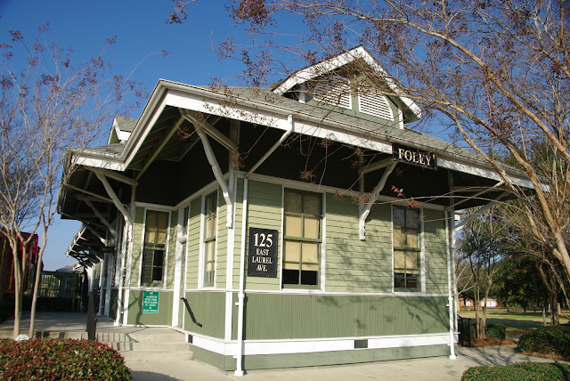
Foley, AL: 1909 Museum/L&N Depot

Model Train Museum: (Satellite)
Railroad Museum: (Satellite)

Street View, Mar 2016

I.e. Xam posted
Foley, L&N-1905  Picture taken in 2010
[The 1905 depot burned. The depot we see today was built in 1909. [Kevin Feeney]]

There is a locomotive on the far end of this lineup.
Joe Dick, Feb 2022

Amanda Monahan, Dec 2023

1943/43 Foley Quad @ 62,500

Tuesday, July 29, 2025

Thief River Falls, MN: City Hall/SOO Depot, Roundhouse & Railyard and Grain Elevator

Depot: (Satellite)
Roundhouse: (Satellite)
Railyard: (Satellite)
Elevator: (Satellite)
 
Street View, Sep 2024

Jim Arvites posted
A current view of the old Soo Line passenger depot at Thief River Falls, Minnesota. The station, built in 1913, has been remodeled and is the Thief River Falls City Hall today.

The roundhouse was tricky to find because they have remodeled it. This is the first time I have seen that much money spent on a roundhouse.
Street View, Aug 2024

Satellite

This grain elevator is so big that I can't fit it into one street view.
Street View, Aug 2024

It appears to be rail served by CPKC because it not only has a fall protector, but it also has its own locomotive parked in the loading shed.
Street View, Aug 2024

In fact, I caught the locomotive out in the wild.
Street View, Sep 2012

And some hoppers being loaded.
Street View, Sep 2018

And the CPKC railyard that is just north of the town has a lot of hopper cars. It looks like it also has some empty coal cars.
Satellite

The bins to the side were built in 2021.
Adam Wells, May 2021

The town also has an old elevator with wood, bolted-steel and rectangular storage bins.
Street View, Sep 2008

A view of the wood end of that elevator.
Street View, Sep 2008

This topo map accurately marks the location of the depot and taught me to look for the roundhouse.
1961/63 Thief River Falls NW and 1959/60 Thief River Falls Quads @ 24,000