.jpg) |
| Darren Reynolds posted Looking west at B&Os "VO" tower Weverton, Maryland 5/1933 By:Henry Wilhelm David Paul: Wow a movable point crossing inside of a double crossover.Randall Hampton shared Gary Elder: Was there once a branch that went up to Hagerstown? From weverton. Dennis DeBruler: Gary Elder Yes. I would include the map from a 1967 employee timetable, but the "photo" icon on Facebook comments no longer works for me. I found the map on pdf page 30 in https://wx4.org/.../1967-04-30B%26O_Baltimore95-seabass.pdf Darren Reynolds posted I'm sorry but I forgot to add B&Os "VO" tower..Weverton,MD .. this tower Tower was closed in the early fifties and the interlocking machine moved over to WB Tower in runswick,MD.. you can see the interlocking machine if you go to the Brunswick railroad museum.. it's definitely worth the trip.. May 1933. Note: this is where the line cuts off and goes to Hagerstown... Other tracks going straight go to Harpers ferry,WV "HF" tower... Wesley Paulson: When was the Hagerstown branch abandoned? Darren Reynolds: Wesley Paulson late '70s early '80s Smoketown History (Brunswick, Md.) added This was the Weverton or "VO" signaling tower, which was decommissioned in the 1950s and demolished sometime around 1960. It was also known as a "Block Station Tower," which along with towers in Brunswick (WB) and Point of Rocks (KG), formed a "block" that managed all railroad traffic between those locations. The WB Tower was the center of the operations for this area from Point of Rocks in the east and Weverton in the west. Old Rt. 340 would be at the upper right of the photo. The Weverton station can be seen in the background along with the water tower. To the left of it is the mainline to Cumberland. To the right is the Washington County Branch to Hagerstown. Who remembers it and exactly where it was located? It was actually in Knoxville, but was designated "Weverton" by the railroad (Photo from Baltimore & Ohio Railroad History courtesy of Norm Cornelius) Tim Shanahan shared |
 |
| Alex Reiser commented on Smoketown's post Approx location of tower. White house across tracks is house on right in photo (note shallow depth of house compared to height). |
 |
| Alex commented on his comment Wider view. Tower was located near lower right corner. The large building with the double-decker porch in the background of original picture is pictured top center across the T intersection |
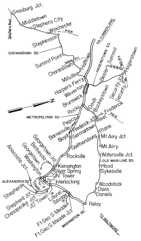 |
| This is the map that Facebook would not allow me to add to the comment. |
 |
| 1955 Harpers Ferry Quad @ 24,000 |
The above topo shows the branch leaving the mainline significantly west of the lockhouse. But this 1969 topo shows the branch did leave down by the lockhouse. I always thought that the topo maps made in the 1950s were rather accurate. These maps teach me that I have to pay more attention to the maps made in the 1960s.
 |
| 1965 Harpers Ferry Quad @ 24,000 |
The more I looked at the photo, the more signalling pipelines I saw. There is a massive number of pipelines along the outside of the left track. And I put a red rectangle around some pipelines that are crossing under the tracks to operate pipelines along the sides of the middle tracks.
 |
| Darren Reynolds post plus Paint |
The B&O Hagerstown Branch.
 |
| 1954 Baltimore Quad @ 250,000 |
I accessed a 1965 aerial photo to try to confirm the location of the tower.
 |
| EartExplorer: Mar 28, 1965 @ 24,000, AR1VBDO00010144 |
 | |
|
Darren Reynolds posted two photos with the comment:
The Baltimore and Ohio Railroads"VO" towerWeverton, Maryland
Shu Mitsui: When did VO go dark?
Darren Reynolds: Shu Mitsui around the late 50s it was closed and the model board was put in "WB" tower...
 |
| 1 "VO" tower was a Standard B&O design( But much bigger) the tower Controlled movements in and out of the entrance of west Brunswick yards..and Controlled the Hagerstown branch..After the tower closed the Interlocking was Controlled from "WB" tower Photo by: Frank Garon Collection |
 |
| 2 Looking West at "VO" tower and the town of Weverton (If you zoom in) you can see the station and hotel Photo by: Henry Wilhelm NRHS May 1933 |
No comments:
Post a Comment