 |
| Roger Kujawa posted Illinois postcard Sahara Coal Company Harrisburg Electric Shovel James Stine: This machine was delivered as a 950-B, but was upgraded to a 1050-B later on in its career. It served the Sahara #6 from beginning to end. I would have to look to tell you how long. I think it went from around 30 yds to 36. Roger Kujawa posted K17/ Harrisburg Illinois Postcard c40s Sahara Coal Mine Company Shovel 325 James R Griffin Sr.: Didn't they do a conversion on that 950 and make it a 1050? Dennis DeBruler: James R Griffin Sr. That is what James Stine states in another post by Roger, https://www.facebook.com/groups/1467664233256543/posts/5880361685320087/. "This machine was delivered as a 950-B, but was upgraded to a 1050-B later on in its career. It served the Sahara #6 from beginning to end. I would have to look to tell you how long." |
 |
| Chicago History posted CTA Green Hornet streetcar 4390 heads south on Clark Street at Addison Street, about to pass Wrigley Field in September 1957 [Looking North along Milwaukee's Chicago & Evanston Branch.] Paul Webb shared |
I now think that this prep plant was at their #1 mine.
 |
| Bill Edrington commented on Paul's share Love the Sahara Coal sign on the silo at the coal yard. Sahara was a major southern Illinois coal producer, located near Harrisburg, and a big customer of the Big Four/New York Central/Penn Central/Conrail for many years. (Photo from the Saline County Historical Society archives) |
I now think that this prep plant was at their #1 mine.
 |
| Roger Kujawa posted Washing and Processing Plant Sahara Coal Co. Mine Harrisburg IL Illinois |
Raymond Barr posted three photos with the comment: "Here are some photos of the Sahara Washer / Mines Nos. 5 & 6 complex West of Harrisburg IL. - From the collection of John P. Kohlberg -"
 |
| 1 |
 |
| 2 |
 |
| 3 |
 |
| Directory |
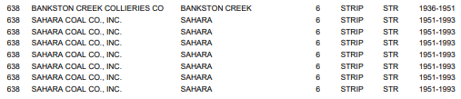
This map for Sahara Coal Mine #6 frustrated me because I could not find a tipple for index #638.
 |
| https://wikiimage.isgs.illinois.edu/ilmines/webfiles/topo-mines/harrisburg.pdf |
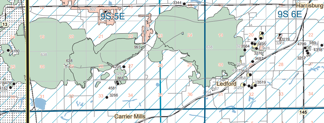
Then I discovered that a lot more of the mine was further to the west. And the tipple was in that part.
 |
| Herrin Coal Seam Map |
A USGS topo map labels the tipple as Sahara #5, but I think that is a mistake. According to the directory, Sahara #5 was a slope mine in the Springfield Coal Seam. (Update: Raymond's comment above indicates this was #5 and #6.)
 |
| Directory |
 |
| 1961 Carrier Mills and Harrisburg Quads @ 24,000 |
The above topo map shows how the NYC/Big Four Railroad had a spur that went west of Harrisburg to serve this and other coal mines in the area. I included the South American Church because the cemetaries tend to last into the 21 century. Sure enough, you can use the cemetery to help locate where the tipple was.
 |
| 1961 Carrier Mills Quad @ 24,000 |
The tipple area at file resolution.
 |
| EarthExplorer: Mar 18, 1959 @ 17,000; AR1VSJ000020017 |
The entire file at 1/4 resolution. The tattoos make you appreciate the work they did to restore the land.
 |
| EarthExplorer: Mar 18, 1959 @ 17,000; AR1VSJ000020017 |
I don't have any overview notes so I'm going to park these here for now.
Raymond Barr posted two diagrams with the comment: "Here are a couple of blueprint-type schematics done in the early 1950s by the New York Central Railroad of its SALINE COUNTY coal mine customers."
Roger Kujawa shared
 |
| 1 |
 |
| 2 |
No comments:
Post a Comment