Museum/CB&Q Depot: (Satellite, 41 photos)
Santa Fe Freight House: (Satellite, only the eastern part of it is left.)
CB&Q Freight House: (Satellite, it is now a parking lot)
Santa Fe Roundhouse & Shopton Shops: (Satellite, see an older image below where it is more evident.)
CB&Q Roundhouse: (Satellite, I marked the location of the turntable. The roundhouse was east of it.)
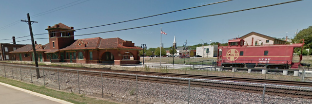
The depot in the center of Martin's post was owned by Santa Fe and the depot on the right was CB&Q. I think the building just beyond the CB&Q depot was their freight house. Note the caboose parked by the CB&Q depot. To my amazement, both depots are still standing but Amtrak uses a relatively new shack down in the railyard.
Is this what they had to choose from for their static display?
Given this topo map...
In the aerial above, we see a backshop above the (West of) the roundhouse.
When I revisited these notes in July 2024 because of the CB&Q roundhouse, the stalls and turntable of the Santa Fe roundhouse had pretty well disappeared.
 |
| Martin Sheridan posted Santa Fe steam powered passenger train leaving Fort Madison for Chicago. I think this photo came from the NLCHS. Looks like 1930s. John Bird shared |
The depot in the center of Martin's post was owned by Santa Fe and the depot on the right was CB&Q. I think the building just beyond the CB&Q depot was their freight house. Note the caboose parked by the CB&Q depot. To my amazement, both depots are still standing but Amtrak uses a relatively new shack down in the railyard.
 |
| Raymond Storey posted Raymond Storey posted FORT MADISON IOWA Mike Bartels: Burlington depot in the background. Robert Chitwood: You can see the original wooden depot to the left. |
 |
| The 29th State posted HISTORIC SANTA FE DEPOT FORT MADISON, IA LEE County For more than a century, the long brick Santa Fe depot along the Mississippi River has watched the trains go by—freight, mail, passengers, you name it. Built in 1910 by the Atchison, Topeka and Santa Fe Railway, the depot was the only Santa Fe passenger stop in Iowa and a symbol of the town’s growing importance on a rail line that stretched from Chicago to California. At a time when the railroad was advertising the romance of the Southwest to middle-class travelers, Fort Madison got a depot that didn’t just do the job—it made a statement. By then, Fort Madison was already a key division point with crew changes, repair shops, and a strategic spot along the line. The new station replaced an older wood-frame building from 1888 and was part of a larger complex that included a freight office and an REA building. Together, these buildings served not only passengers, but also the mail and packages that flowed through town daily. For years, the depot was the front door to Fort Madison—a place where soldiers shipped off to war, families reunited, and salesmen started their circuit. In 1945, the interior got a modern refresh with sleek mid-century styling, but just two decades later, the Santa Fe built a smaller station out near the rail yard, and the downtown depot went quiet. After the trains stopped in 1968, the city bought the old depot complex for a dollar and leased it to the North Lee County Historical Society, which set up a museum. Over the next four decades, volunteers raised hundreds of thousands of dollars to keep the buildings standing—replacing windows, patching roofs, and keeping the lights on. But floods from the nearby Mississippi kept coming, and eventually, it became clear that preservation meant more than patchwork. In 2011, the city and its partners made a bold move—literally lifting the depot off its foundation, building a five-foot-high base, and setting it back down above flood level. It was a massive, multi-phase project that took more than a decade and drew on federal, state, and local funding—including transportation grants, I-Jobs infrastructure dollars, and support from Amtrak and BNSF. The final touches included a new platform and updated interior spaces for both Amtrak passengers and museum exhibits. In 2022, the city earned statewide recognition for the effort, named an “All-Star Community” by the Iowa League of Cities for its work in historic preservation. Amtrak began using the restored depot in December 2021, marking the first time the Southwest Chief had ever stopped there. It was a long-overdue homecoming that honored the past while giving the old station a new lease on life. And in a town where more than 100 freight trains still roll through every day, it feels right to know that the Santa Fe depot is once again part of the journey |
The wooden depot was replaced by a freight house. Only the eastern part of the building remains. Most of the one-story freight handling part has been turned into a parking lot.
 |
| Street View, May 2023 |
This aerial not only shows the complete freight houses, it shows boxcars parked at the freight houses.
 |
 |
| David Cenci posted CBQ and ATSF depots at Ft. Madison, IA 5-25-24. |
 |
| Street View, Aug 2012 |
It appears the caboose has been repainted between 2012 and 2018, which is good because it was demonstrating that Santa Fe red fades to pink. I've seen that "pink" color on some of their locomotives.
 |
| Street View, Apr 2018 |
 |
| Street View |
Is this what they had to choose from for their static display?
 |
| Keith Hoy posted RAILROADING. M Dennis DeBruler shared I wish I knew where these were. I used to see a Santa Fe caboose on BNSF locals in Joliet and further south as a shoving platform. Brian K. Munson: From my 42 years in the business once you take spray paint and put a line through the number on any equipment, it’s ready for the torch. Dan Pulsford: Ft Madison, IA; 15 years ago. |
 |
| Josh Clark posted To the dismay of most, I’ve got to say that I’m a diehard for ATSF history and operations. I knew it was a must to go for the Warbonnet dash 9 duo on BNSF’s West Quincy-Wever local freight. This job is best shot under clouds due to the northbound run in the PM. However, the weather said different today. I decided to go wide with my flying camera, and I’m glad I did. In the shot is downtown Fort Madison, CB&Q depot, ATSF depot, and a nicely restored ATSF caboose. What turned into a 550 mile day trip was all worth it, I’ve always been told to shoot what you can before it’s gone! [The locomotives show how Santa Fe red fades to pink as it ages.] |
 |
| Bill Steinhauer posted Fort Madison Iowa |
 |
| Tom Pearl commented on Bill's post the other side viewed from Amtrak |
The interior of the Santa Fe depot. There are also some exterior and interior shots of the caboose on Google Maps. The exterior shots are also red instead of pink. And the interior shots look quite authentic, ripped upholstery and all.
 |
| Hugo Hackenbush, Oct 2018 |
Given this topo map...
 |
| 1964 Niota and Fort Madison Quadrangles @ 1:24,000 |
...I looked for the foundation of the Santa Fe roundhouse. I did find evidence of a roundhouse and turntable. I marked the turntable. But the roundhouse foundation is north of the turntable whereas it was south of the turntable on the topo map. So I'm confused.
 |
| Satellite |
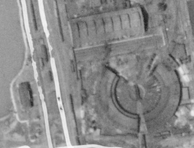
Then I remembered that the Illinois aerial photo collection includes a set of photos taken along the Mississippi River. In this photo excerpt, North would be approximately to the right. The topo map above shows what was left of the Santa Fe roundhouse in 1964.
 |
| 1927 Aerial Photo from ILHAP |
In the aerial above, we see a backshop above the (West of) the roundhouse.
 |
| Tim Starr posted Shopton (Fort Madison) Iowa shops of the Santa Fe around 1890. Large limestone building is the locomotive erecting shop with 16 pits. The roundhouse is out of view behind it. On the left is the car shop. (John Barriger collection) |
Tim Starr posted two images with the comment: "Fort Madison, Iowa had 2 roundhouses at the Santa Fe shops for a short time, but then took one down for some reason. The first map is 1889, the second is 1900. They were built in 1887, so the second roundhouse didn't last long. Unfortunately I can't find any other reference to it. This neighborhood was known as Shopton because it was somewhat separated from the main town on the west side."
Richard Shulby: Tim- GREAT FIND! Thanks for posting! Too bad Sanborn never included the other side of the creek- then we might have a better idea as to when the other RH disappeared. Do you have access to the 1926 or 1946 versions (LOC does not have online)? Strange setup for the roundhouses, with the west RH access ONLY through the turntable of the east RH or through the transfer table. You state they were both built in 1887- can you share that information source? To me it appears that one would have been built first, followed by the second. To me that might suggest that the east RH buildings were done first, followed by the west RH which could have been built to replace the first, with temporary service track access through the east TT. Of course it could have been the other way around as well. Note also the reference to the CB&KC RR in the upper right of the 1889 view, just below the CB&Q reference. I can only find one reference to a CB&KC Ry in the attached AT&SF Kansas Historical Society reference, but it does not spell the full name out.
Tim Starr: Richard Shulby The Chicago, Burlington and Kansas City was merged into the CB&Q. It wasn't around very long so there aren't many mentions of it.
 |
| 1 |
 |
| 2 |
 |
| Tim Starr commented on Richard's comment The smaller roundhouse closer to the city center is labeled CB&Q in this 1916 map. |
 |
| Tim Starr commented on Richard's comment In 1900 the small roundhouse is owned by the Chicago Fort Madison and Des Moines. |
When I revisited these notes in July 2024 because of the CB&Q roundhouse, the stalls and turntable of the Santa Fe roundhouse had pretty well disappeared.
 |
| Satellite |
 |
| Martin Sheridan posted Pulling down the CB&Q roundhouse in Fort Madison, Iowa 1981. Photo: Fort Madison Daily Democrat. |
An excerpt showing the Peavine Line leaving the depot area. Today's 16th street repurposed the RoW.
 |
| Fort Madison Quadrangle @ 1:24,000 |
 |
| Dennis DeBruler commented on Martin's post Today's 16th Street was built on the RoW of the Peavine Line, and it ran just south of Avenue I. The intersection in the upper-right corner of this 1957 aerial is Avenue G and 15th Street. https://chf.isgs.illinois.edu/1957/001007/1T_RX_0126_downsampled.jpg |


No comments:
Post a Comment