Tuesday, January 31, 2023

Abernant, AL: Drummond Twin Pines (Shannon) Mine and Mr. Tom Dragline, B-E 1570

(Satellite)

In case they ever move the dragline, I saved the satellite image.
Satellite

Matt Weyand posted two photos with the comment: "Stopped by to see Mr. Tom today.  Does anybody know why the back doors are open on the house?"
Tommy Black: They just spent 30 million rebuilding it and moved him cross country 18 miles ,no way they scrapping it.
Nate Nowak: Tommy Black how long has it been sitting since the rebuild and move?
Bruce Pennington: Nate Nowak About 11 years

1

2

It last dug dirt in 1995.
Kelly Michals Flickr, 1 of 115 photos via al
License: Creative Commons Attribution-NonCommercial (CC BY-NC) 
Bucyrus Erie 1570 Walking Dragline Mr. Tom
Double Clutch 73 11y : I hear this machine is in the process of being restored and is going back to work.
Cleve Whatley 4y : While it was being restored the coal market fell and it never went back to work. It walked from the old mine it was working near Kellerman to Twin Pines near Abernant and was parked until the market came back.

al, the fifth of ten photos of it walking the 17 miles
After a year of work, the Drummond Co. has brought a 20-story tall dragline crane, called Mr. Tom, back to life and is now moving it about 17 miles from Brookwood to Abernant.
"Along the path, Mr. Tom moves about one mile per day, one three-foot step at a time."

I can't decide if it walks forward or backwards. Note high high they cover the road with dirt before they walk over it.
al, the first of ten photos of it walking the 17 miles
"Each time Mr. Tom has crossed a road, the road must be closed. The Alabama Department of Transportation allows such a road closure to last only a day, and when the company is done, the road must be returned to its previous condition. Before the sun rises, earth-moving crews set to work, covering the highways with a dirt bridge, which Mr. Tom crosses early in the morning. As soon as the machine crosses the gap, bulldozers, track hoes and dump trucks remove the dirt bridge. When Mr. Tom crossed U.S. Highway 216 on either side of Brookwood, the highways were set back so meticulously that the grass on either side of the road looked as though it had never been touched, much less buried, under tons of earth and crushed by such a huge machine."

In a mine, it would get its electricity from the grid.
al, the fourth of ten photos of it walking the 17 miles
"As quickly as the demand for metallurgical coal spiked [in early 2011], in the last year the price has fallen just as fast. Coal that was selling for more than $300 per ton is going for half that much today [Jan 2013]."

I don't know if this was at this pit, but it is a Drummond operation.
Wendell Bennett posted five photos.
1

2

3

4

5

Michael Davis Flickr

"Late last year, the company fired up Mr. Tom, its nickname for a giant 1970s-era dragline, to strip coal at the company’s Shannon mine, southwest of Birmingham. Mr. Tom is a 3,750-ton crane with a 320-foot (98-meter) boom that swings a bucket big enough to scoop up four Toyota Priuses. In January, Drummond moved the dragline 18 miles from an old mine near Brookwood, Alabama, to the Shannon mine on mechanical feet. The state required the company to write a 22-page cultural resource assessment of artifacts that Mr. Tom might crush on its journey." [fa-mag]

Are these 27 Steve Kole 1976 photos (source) of this mine or another Drummond mine?


Monday, January 30, 2023

Brooklyn, IL: TRRA Backshop and Roundhouse and ESLJ Roundhouse

TRRA: (Satellite)
ESLJ: (Satellite, if the foundation is still there, the trees are covering it.)

ESLJ = East Saint Louis Junction Railroad      It was a subsidiary of C&NW.

David Cantrell posted two images with the comment:
Roundhouse map of TRRA shops in Brooklyn, IL from John W. Barriger III National Library, August 9, 1957.
And 1938 aerial view of roundhouse from Illinois Historical Aerial Photographs.

1

2

Dennis DeBruler commented on David's post
Thanks for including the link. That allowed me to download a resolution higher than the Facebook copy so that I could read the labels in the backshop. I think the roundhouse on the left in the 1938 aerial was the East Saint Louis Junction Railroad. According to the 2005 SPV Map, it was a subsidiary of C&NW.

Dennis DeBruler commented on David's post
You can still see the remnants of the service pits of the backshop and roundhouse.
https://www.google.com/maps/@38.654052,-90.1599628,429m/data=!3m1!1e3

Dennis DeBruler commented on David's post
I was surprised that a topo map showed that it was still standing in 1998. So I fired up Google Earth. The buildings are in a Apr 1998 image, but gone in the next image, which is Mar 2002.
1998 Granite City Quad @ 24,000

David Cantrell commented on Dennis DeBruler's comment concerning the backshop diagram
 I concluded that the roundhouse on left was originally a Wabash railroad facility based on maps that showed Wabash rails closest to it. Unsure if that is the true origin.

Dennis DeBruler commented on David's comment
The yard to the west of the roundhouse is Wabash. But the lead to the roundhouse appears to be coming form the line that goes over to National City. That line is the ESLJ.
1954 Granite City Topo @ 24,000

Dennis DeBruler commented on David's comment
 I just saw that the underlying contemporary map for topo maps labels a remnant of track for the East St Louis Junction RR. But it also labels a track with Chicago & Northwestern instead of UP. And the tracks on the map are not consistent with the reality of a satellite image. So that map has some significant errors.
https://livingatlas.arcgis.com/topoexplorer/index.html


Sunday, January 29, 2023

New Roads, LA: Big Cajun Power Plants

#1: (Satellite)
#2: (Satellite)

#1 is a 430mw gas-fired plant. [cleco1] #2 was the first coal-fired power plant built in Louisiana with a rating of 1,708mw. [cleco2]
gem2 rates #2 as 1.9gw. I wonder why each unit got smaller. Normally, newer units are bigger. "Unit 1: 657.9 MW (1981), Unit 2: 626.0 MW (1982), Unit 3: 619.0 MW (1983)" Unit 2 was converted to a 540mw natural gas plant in 2015-16.
Power-Technology rates Cajun 2 as 1,276.9mw. The subbituminous coal comes from the Powder River Basin. I wonder where the PRB coal is transloaded to barges because, according to the satellite image, this plant can't receive coal by rail. It can use just barges on the Mississippi river. And do they transload further south in the Winter?
Greg Mallory posted
Big Cajun II in New Roads. LA. I started my career there and they were outside units. Burner decks had some sheathing. The brown metal "buildings" are roll away enclosures over the turbines. The enclosures were open and turbines exposed most of the time. Units 1 & 2 (right) were Riley Stokers, Unit 3 was a B&W (left). I was a AO & CRO on U#3 for years.
Andy Kapper: God outdoor units covered with a box, so ugly lol
Greg Mallory: Andy Kapper , they were a godsend when the temperatures where 100F outside. Enclosed units in the south are unbearable, I remember coming out from under the turbine mezzanine and walking outside to 95F and it felt like walking into a chiller! No telling how bad it would be on a enclose burner deck in the south!
Gordon Jones: how many MW?
Greg Mallory: Gordon Jones started as 540 each. I think they all have dense packs now and not sure where they’re at now. I ran them many times near 575 when load was needed.
Gordon Jones: Greg Mallory 👍….we had four Supercritical 630MW dense packs. dayton power and light JM Stuart Station.
Greg Mallory: Gordon Jones BTW, Unit #2 is now gas, converted a few years ago.

The comments on this Texas plant post indicate that outside units are cheaper to build but won't last as long.

Two of the units in #1 are steam-turbine units that went online in 1972. Two simple-cycle combustion turbine units are used for peaking power. [cleco1] In 2007, plans were "to replace two of its natural gas turbines at Big Cajun I with a 230 megawatt (MW) coal-fired unit." [gem1] It seems the Sierra Club effectively stopped those plans.
Unit 1 in Cajun 2 is scheduled for retirement in 2015. [gem2]

Street View from John James Audubon Bridge

"In September 2009, NRG announced it was replacing some coal at Big Cajun II with switchgrass and sorgham. The company said the project could eventually lead to commercial-scale biomass fuel projects as a means of dealing with potential greenhouse gas regulations." [gem2] Evidently this experiment failed because I haven't seen a more recent report of burning biomass.

GasToPowerJournal
Kurt Schroeck posted
For sale

nola (Photo by Richard Alan Hannon, The Advocate)
[The planned 2015 closure date is probably because of the 2015 wastewater regulation.[

This plant not only has a big wastewater pond, it is on a Mississippi River flood plain. I wonder if a flood has recently flowed over this land.
Satellite

The conversion of Unit 2 to gas was part of a $250m upgrade to settle an EPA suit in 2012 regarding the EPA's new regulations concerning mercury. [ens-newswire]

Kurt Schroeck posted
Cajun Electric, Big Cajun II Power Plant 1979. This was the first time I set eyes on the plant. I would later become Lead Engineer for Unit 2 start-up 600MW coal fired; 27 years old.
George K. Vaughan: We will soon be building new boilers for hydrogen collection.
Michael J. Sullivan: still running?
Kurt Schroeck: Michael J. Sullivan Yes, Unit 2 converted to gas only.


Saturday, January 28, 2023

Apollo, PA: 1912-1947 Apollo Steel - first sheet mill driven by electricity

Mill: (Satellite)
Plutonium Lab: (Satellite [cdc, p24])

Chuck Half posted six images with the comment: "Apollo Steel 1912 -1947 was started by my grandfather as the first sheet mill driven by electricity. This article describes a 1922 expansion in extensive technical detail. I enlarged the pic of the GE 1,800 hp motor. Plant capacity grew to 120,000 tons of cold rolled, galvanized,  and blue annealed sheets up to 60 inches wide."
Sam Burkett: Is this where the old Numec was?
Chuck Half: Sam Burkett Yes, bringing to that site health issues....
1

2

3

4

5

6

Dennis DeBruler commented on Chuck's post
It appears that the mills were on this brownland:
https://www.google.com/maps/@40.5861373,-79.5690816,986m/data=!3m1!1e3
Apr 3, 1969 @ 16,000, AR1VBZB00010015
And the plutonium lab was on this brownland:
https://www.google.com/maps/@40.6257348,-79.5867786,498m/data=!3m1!1e3

Thursday, January 26, 2023

La Salle C: Jonesville, IL: LaSalle County Carbon Coal Jones Mine

(Satellite, the tailings pile and a tree line for the CB&Q spur still exists)

Andy Zukowski posted
Carbon Coal Mine NO 1 Mine, Jonesville, Illinois 1905

Dennis DeBruler commented on Andy's post
This map shows that the eastern shaft was south of IL-351.
https://wikiimage.isgs.illinois.edu/ilmines/webfiles/topo-mines/lasalle.pdf. p2

Dennis DeBruler commented on Andy's post
But I think it was north of the road because that is the location of the tailings pile and the CB&Q spur. Production ended in 1930, and they evidently removed their buildings by this 1939 aerial photo.
https://clearinghouse.isgs.illinois.edu/webdocs/ilhap/county/data/lasalle/flight11/0bwy03035.jpg

Dennis DeBruler commented on Andy's post
The .pdf file indicates that shafts #238 and #237 were escape routes for shaft #3.

pdf, p15


Roger Kujawa posted three photos with the comment: "1911 from Peru, Illinois coal mine, shafts and coal crusher."
[Actually, this mine was on the other side (south side) of the Illinois River.]
1

2

3


Fergus Falls, MN: 1948+1959+1964-2021 137mw Otter Tail Hoot Lake Power Plant

(Satellite)
Plant Nameplate Capacity: 136.9 MW (Megawatts)
Units and In-Service Dates: Unit 1: 7.5 MW (1948), Unit 2: 54.4 MW (1959), Unit 3: 75.0 MW (1964)
Unit Retirements: Unit 1 retired in 2005, Units 2 and 3 retired on May 27, 2021
In January 2013, the Minnesota PUC approved a plan to convert the plant to natural gas by 2020. In addition, Otter Tail will install pollution controls at the plant by 2015.[7] In 2019 it was reported that the facility will not be converted but replaced by a new powerplant with a 245-megawatt natural gas combustion turbine, to be build southeast of Watertown in east central South Dakota. The facility will be known as the Astoria Station.
[gem]
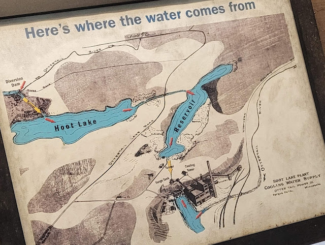
This was originally the site of a hydro plant. They built a new steam power plant in the middle of the 20th Century.
Jeremy Umlauf, May 2021

Adam Bibeau commented on a post

The leather belts caught my eye in this view.
Jeremy Umlauf, May 2021

Jeremy Umlauf, May 2021

It has gotten to the point that any satellite image that still shows a coal pile is worth noting. But I also wanted to understand the hydro plant. The blue circle highlights the plant; green is the headrace; yellow is the tailrace; and red is the surge tank.
Satellite plus Paint

Diversion dam:
Satellite

Street View, Sep 2008

The entire water flow. The diversion dam is in the upper-right corner and the plant is near the lower-left corner.
1973 Fergus Falls Quad @ 24,000

Steam Plant

I made sure to include the surge tank on the left.
Street View, Sep 2008

Some photos from a photo album at otpco. This site also has a couple of videos about the plant's retirement that I did not bother to watch. 
a
Hoot Lake Plant Open House, 1959.

b
Boiler, 1948

c
Unit 2, 1963.

d
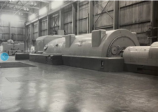
Turbo-generator set, 1923.

e
Equipment inside the power house, 1921.

f
1960s

g
Exterior View, 1930s.

h
The plant as viewed from the North Country Trail.