Thursday, August 31, 2023

Beading Berks, PA: 225mw Titus Power Plant

(3D Satellite)

Three 75mw units. [gem]

Glenn Angstadt posted
Supported IT systems at this great station. Memories!
 https://www.gem.wiki/Titus_Generating_Station

"Once a 243-megawatt coal-fired power plant, the site was retired by its previous owner in 2013 and decommissioned in June 2014." [dced]

ReadingEagle
Joe D’Ascenzo, shown in the former Titus Generating Station in June 2020, has bought the former coal power plant facility and plans to turn it into a plastic recycling facility that would take trash and turn it into plastic pellets.
[This web page has 11 more photos of the plant.]

"ReFined Plastics uses a process called pyrolysis, which is high heat without oxygen to break down waste. It is has been a mechanism to turn plastic waste into jet fuel. The pellets would be virgin grade, meaning they are a quality that could be used by a variety of plastic manufacturers. The material won't originate in the recycle bin but will come from household trash." [yahoo]

I encountered the term "pyrolysis" just a few hours before in a proposal to make graphite and hydrogen from coal.


Willow Islands, WV: 1979 1.3gw Pleasants Power Plant

(Satellite)

Street View, Jun 2023

William B. Hearn posted
This morning [Aug 30, 2023] at Pleasants Power Station. Unit #1 back on line!!
William B. Hearn shared
Joey Argubright: What type of boiler is it that it can just convert to hydrogen? I feel like it burns way different.
William B. Hearn: Joey Argubright They came back online with coal. The boiler conversion will take place in about 2 years after the coal to hydrogen plant is built on site. They will also produce high-grade graphite for EV batteries. The amount of coal used by the plant will probably double.
 https://en.wikipedia.org/wiki/Hydrogen_production

Omnis Global Technologies, who bought the plant. plans to build a plant next door that makes graphite, which is in demand to make batteries for electrical vehicles. The process that makes graphite from coal produces hydrogen as a byproduct. So they will use the power plant to make use of the hydrogen. But this process has never been done on this scale. Some analysts don't believe Omnis can do it. "Hodson acknowledged the challenges facing other graphite makers and power companies, but said Omnis has technology to overcome the obstacles after spending 12 years refining its pyrolysis process. Pyrolysis normally generates large amounts of greenhouse gas emissions, but Hodson said he has developed a way to eliminate those by heating the material at temperatures above 5,000 degrees Fahrenheit." [politico]

wvgazettemail, courtesy of Omnis Fuel Technologies
"Omnis intends to double the amount of coal that traditionally has been consumed at Pleasants as a hydrogen-run plant, Hulme said. Under Quantum Pleasants, technology would convert coal to hydrogen through an ultra-high-heat process that doesn’t burn the coal. Instead, hydrogen produced by vaporizing coal particles at high heat — around 3,000 degrees Celsius — will be piped into the power plant, with electricity generated from burning the hydrogen, according to Hulme. Hulme estimates roughly 60% of the coal mass would come out as graphite, yielding 3 million-3.5 million tons of graphite per year."

1 of 3 photosposted by Save Pleasants Power 
Journey complete, both Units at Pleasants Power back online.
William B. Hearn shared

Comments on the above post


Wednesday, August 30, 2023

Boulder, CO: Restaurant/CB&Q/Colorado & Southern Depot

Original: (Satellite, on 14th Street north of Canyon Blvd.)
Current: (Satellite)

Richard Crabtree posted
Here we see Colorado & Southern No. 900 E-5A 2-10-2 built by Baldwin Locomotive Works in 1915.
No. 900 is pulling a freight train at Union Depot in Boulder, Colorado October of 1958.
Photo by John Bernard Schoolland
Richard Crabtree shared
Mike Bartels: Old Union Depot replaced by new building out on the main line in 1957.
[And this building was moved so that 14th Street could become a through street.]

Richard Crabtree posted four images with the comment:
Union Depot in Boulder, Colorado
Built by the Union Pacific Railroad in 1890 it would serve the Union Pacific, Colorado & Southern and Colorado & Northwester Railroads
it was located at 14th Street and Canyon Boulevard (then Water Street), where the Union Pacific Railroad began construction on the depot using locally-sourced stone from Boulder County quarries. The project cost a cool $16,000 in 1890.
in 1957 Railroad passenger service closed to the old depot in downtown Boulder. It then became a bus depot until 1972 when the city made plans to demolish it at its location on 14th and Canyon.
The building was saved by a number of concerned citizens and was relocated to 30th and Pearl Street. Now a historical landmark, the depot was used as an event center until acquired by the city in 2008 and moved to Boulder Junction, near the Northern and Santa Fe railroad 2366 Junction Place Boulder, CO 80301
CLICK HERE FOR CURRENT VIEW
Photo 1) Union Depot Boulder Colorado 1890s
Photo 2) Union Depot Boulder Colorado 1906 Sanborn Map L.O.C.
Photo 3) 1906 Colorado & Southern train ticket Union Depot Boulder Colorado
Photo 4) Union Depot at 30th (Thirtieth) and Pearl Street as it is prepared to be moved to a new location in Boulder, Colorado in 2009 Photo Thomas Jacob Noel
Richard Crabtree shared
1

2

3

4

Dennis DeBruler commented on Richard's post
The railroads met on the east side of town and did street running down Canyon Blvd. to reach the depot. 1957 Boulder and 1951 Niwot Quads @ 24,000

Dennis DeBruler commented on Richard's post [AR1HJ0000040035]
As shown by the Sanborn Map, Canyon Blvd. was railroad property west of the depot. 1948 aerial photo

Street View, Nov 2017

In the satellite image, you can see that the other side has the bay window and would be on the trackside. But I could not get a street view of that side.

Tuesday, August 29, 2023

Crystal Lake, IL: C&NW Depot, Water Tower and Coaling Tower

Depot: (3D Satellite)
Engine Servicing: (Satellite) Long gone.

McHenry County Historical Society posted
This 1955 east bound view of the station area in Crystal Lake is interesting for three reasons. Note the large black water tower in the center left of the photo. This was used as a water station for commuter steam engines. The foundation of that tower can still be found at the southeast corner of the Main Street crossing of the tracks. Beyond the water tower the coaling tower used to fuel steam locomotives can be seen.
Note the truck at the far right of the photo. That is a Railroad Express Agency truck, a predecessor to United Parcel and FedEx in the days when packages came by rail to local communities. Finally, note the passenger railroad car located at the far left of the photograph. That is a very early bi-level passenger car, similar to those used today. That car came into use in 1955.
A Richard B Harrison: I was the trainmaster at crystal lake for a few years. My office was in this depot building at the West End.
Kevan Davis: I see two water tanks, and im not counting the one on the building. [I saw two as well.]

William Lambe shared
Paul Hillmer: Kalmbach Model Railroad Planning issue last year had a great article on making a model of that area.
Bob Jungmann: Had they used their heads when they remodeled the train station within the last 10 years they COULD have moved it across the tracks and turned it 180 degrees so that commuters had a warm place to wait for trains. The little "shelters" with the "toaster oven" heaters 5 feet above the heads of commuters just don't make it in our Winter season. In Barrington they moved the entire brick train station 3 blocks and away from the tracks and made it into a restaurant---why didn't they move the C.L. station to be more "user friendly ?? If you cross the tracks when the lights are flashing the fine is $500.00---that "cash cow" would have disappeared had the station been moved into a better position to serve commuters. With many people now working from home, maybe those commuter trains will go the way of the steam engine.

Doug Murphy posted
I hope you enjoy this 1955 east bound view of the station area in Crystal Lake which is interesting to me for three reasons: 1) the large black water tower in the center left of the photo. I think the foundation of that tower can still be found at the southeast corner of the Main Street crossing of the tracks. Beyond the water tower is the coaling tower. 2) Note the Railroad Express Agency truck at the far right. Finally, 3) note the early bi-level car that was new in 1955.
Tyson Park: In addition to multiple Metra trains UP runs a unit grain train to and from Janesville on this line. It originates in Evansville, WI, runs loads southbound then returns with empties. A way freight also out of Janesville comes all the way down once or twice a week to work local industries and will pass the Crystal Lake downtown depot to back up onto the wye just to the east then head up to the Terra Cotta Industries (TCI) plant on the line the McHenry line, going under the Harvard Subdivision. A very rare train that passes through Crystal Lake is movement of massive marine engines from the Fairbanks-Morse plant in Beloit. UP runs specials for them with idler cars on the end.
William Moyer: Thanks for posting! There are actually two water towers in the photo, but the camera angle makes it difficult to distinguish one from the other. The tank in the foreground held 75,000 gallons, whereas the taller tank behind it held 125,000 gallons. Both tanks were erected in 1927. Toward the left side of the photo, between the tracks and the platform shelter, there's a penstock for filling the tenders of locomotives on the left-hand track. Out of the picture, to the right of the tracks and behind the photographer, there was another penstock for filling locomotive tenders on the right-hand track. I vaguely recall seeing men using a torch to cut up those water tanks in 1962, when I was a kid

Street View

I checked out a topo map before looking on the satellite because I didn't expect an old building to still be used. I was surprised to see the black rectangle on the south side of the tracks since UP/C&NW runs left-handed. Bob's comment confirms that the depot on the south side is an issue. Note the turntable over by the junction. This would be part of the engine servicing facilities than included the water towers and coaling tower. Crystal Lake is no long the terminus for the commuter service. See the junction notes for more information about the commuters.
1962 Crystal Lake Quadrangle @ 1:24,000

Street View, Jun 2019


Monday, August 28, 2023

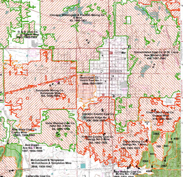
Williamson C: Herrin, IL: Various Coal Mines

Consolidated: (Satellite, the tipple was east of the remnant of a dam.)
#2 Mine: (Satellite?)

Consolidated #7, New Monarch Mine

 
Roger Kujawa posted
Herrin Illinois Consolidated Coal Co. Color Lithograph Vintage Postcard U6501


Not only have the railroads and roads changed a lot, they have removed a dam and its lake.
1963 Herrin Quad @ 62,500

This is the most recent topo that is available, and the lake still exists.
1978 Herrin Quad @ 24,000


#2 Mine


Andy Zukowski posted
NO. 2 Mine in Herrin, Illinois. 1903

Dennis DeBruler commented on Andy's post
This one is a mystery. There were a lot of mines around Herrin, but none of them were #2.
https://wikiimage.isgs.illinois.edu/.../topo.../herrin.pdf

Dennis DeBruler commented on Andy's post
The cartographer didn't bother to add tipple icons to the map.
1910 Herrin Quad @ 62,500


Du Bois, PA Falls Creek (FC) Tower: B&O vs. Pennsy

(Satellite)

Street View, Jul 2018

Marty Bernard posted
3. B&O Tower FC (where). The slide processing date was July 1975.
John Jambor commented, "Falls Creek tower north of Dubois, Pa."
These are Bill Howes' photos from Reid Adams' collection
Marty Bernard shared
Jonathan Dziomba: BR&P (Buffalo, Rochester, and Pittsburgh) FC for Falls Creek, located just outside of Dubois at the beginning of there massive Yards through the City. 2 Diamonds were located here with the Former PRR line from Driftwood heading toward New Bethlehem, and the PRR line coming out of Ridgeway. Beautiful tower

1944 Du Bois Quad @ 62,500 via Dennis DeBruler

Sunday, August 27, 2023

Elroy, WI: C&NW Roundhouse, Water Tower and Depot

Roundhouse: (Satellite, it was in the northwest quadrant of Juneau and 2nd Streets)
Depot: (Satellite, street view doesn't have good coverage of this town)

All of the C&NW property has been abandoned.

Chicago & North Western Historical Society posted
An interesting snapshot taken by someone on a fan trip up to the C&NW facility at Elroy, Wisconsin in October 1953. The photo is from the Jim Scribbins collection.

Kim Potaracke commented on the above post
nd. [I don't know what "nd" means, but the marking on the photo confirms that it is Elroy.]
William Moyer: Here's a link to a Sanborn Fire Insurance map from 1914 that shows the Elroy roundhouse. From the Library of Congress collection. https://www.loc.gov/resource/g4124em.g095441914/?sp=3&r=-0.094,0.055,1.17,0.658,0
Chicago & North Western Historical Society posted
Kim Potaracke: As of 2022: The Elroy Depot constructed in 1872–73 still stands and today serves as the Elroy Area Fire Department building. [Street View has not covered this town very well.]
Tom Edwards commented on the post by the Chicago & North Western Historical Society
Unfortunately, the Sanborn fire insurance map company didn't cover the north end of the Elroy rail yard, only up to the middle of the roundhouse. Here are two pages of their 1914 map that I've enlarged the text from the railroad's buildings and a few rail-served customers.
 
Dennis DeBruler commented on the post by the Chicago & North Western Historical Society
1938 aerial photo

1927 Hillsboro Quad @ 62,500

Dennis DeBruler commented on the above post [AR1YT0000010041]
Two thirds of the roundhouse had already been removed by this 1954 aerial.
Brian A Morgan: Dennis DeBruler. I am sure this was due to the fact that C&NW executives and management decided to centralize the shop facilities in Altoona, Wisconsin for heavy repairs and rebuilding and maintain a minor shop area in Elroy for running repairs of both freight and passenger units between Madison and Saint Paul.
.

Depot


Mark Llanuza posted
Its June 1984 a crew change at Elroy Wis station .This is coming from St Paul with Senior Vice President Jim Zito along with other officials with Head Chef Sugar Cane making breakfast .this train made a stop at North Freedom where the CNW made a donation for steam engine 1385 for the museum and continued its summer inspection trip to Chicago.
Joe Holman: And in three more years, no RR in Elroy anymore.
Chris Goepel: Joe Holman when did the last revenue trains operate over the Reedsburg-Wyeville segment through Elroy? Thought it was about 1984-1985.
Joe Holman: Chris Goepel, Elroy to Camp Douglas 1986 and Reedsburg to Elroy 1987. West of Camp Douglas, the track is still intact. There is an active frac sand customer about three or four miles east of Wyeville called Smart Sand that is accessed from Wyeville. Between Smart Sand and Camp Douglas, the track is overgrown with vegetation. It had been used for car storage over the years, but is now inactive.

Mark Llanuza posted
Its April 1984 a crew change at Elroy Wis station after a long trip from Chicago IL .This is the Chicago -Madison- Baraboo division .at this point it turns into the former Omaha road division .today this is a bike trail .To the left it went to Wyeville -St Paul and to the far right it the old Sparta line.
Jim Dickerson: There were no locks on the rooms at the hotel to the left, where us railroad men stayed. They only had 1 bathroom per floor.
Dave Casey: The hotel is still standing, but needing a lot of TLC. There's an Irish Pub across the street now called Maddens - worth a stop if in the area.

Larry Foht posted
This is the Eleroy Illinois Depot on the Iowa division of the Illinois Central Railroad
Larry Foht collection :

Mark Llanuza posted
Its June 1984 Southeast bound Elroy -Madison Frt is ready to leave with a few reefer   Cars next to the station ,This side of the station east side was the original Elroy to Sparta cut off that went through three tunnels .Passenger trains stopped using this section in 1955   .This side of the station  was finally abandon around 1965 and was made into a bike trail sometime in the 70's. The line to the far right  is the section that went to Camp Douglas and Wyeville -St Paul looking north I went back in the summer of 2022 to try to line up as best as possible .The line to the far right was taken out of service in March 1987 and now is another bike trail with one tunnel.

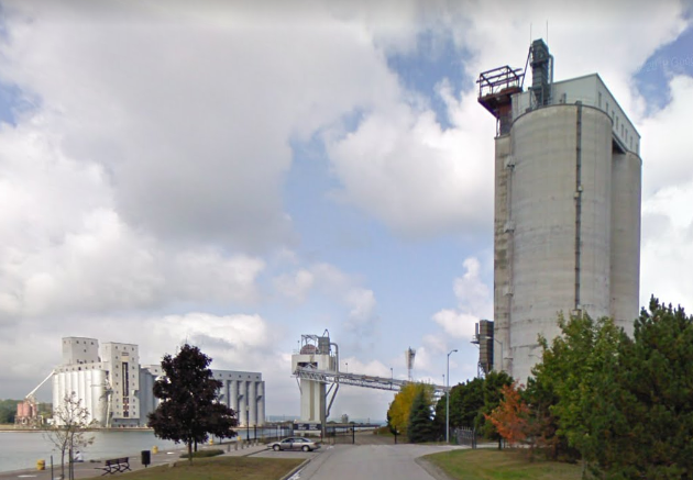
Owen Sound, ON: Miller Cement Terminal

(Satellite)

Note the Great Lakes Elevator in the left background.
Street View, Sep 2009

Another example of an articulated tug barge (ATB).
Jeff Dickinson posted, cropped
Unloading cement in Owen sound August 23

Chris Evie Evans posted via Dennis DeBruler

Saturday, August 26, 2023

Vashon Island, WA: Ferry Dock

(Satellite)

Steven J. Brown posted
Washington State Ferries Issaquah Class M/V Issaquah (built 1979) offloads at the Vashon Island Ferry Terminal, Vashon, Washington - August 20, 2001.
The Seattle Metro Bus 3195 is a Gillig Phantom 35' built in 1997 and retired in 2015.
Dale Skyllingstad: Interesting fact, the Issaquah-class ferries use two of the same prime movers as the B32-8. Although these are direct drive through a gearbox and not diesel-electric.

The lane on the right goes East to Fauntleroy and Seattle whereas the lane on the left goes West to Southworth.
Street View, Oct 2021

Bella Official, Jun 2021, cropped

G C, Aug 2023, cropped


Keithsburg, IL: CB&Q Depot, C&NW/M&StL Depot and Cargill Grain Elevator

CB&Q Depot: (Satellite, Cargill's entrance is on the depot's land)
C&NW Depot: (Satellite, 13th Street extended and north of the spur's remnants.)
Cargill: (Satellite)

M&StL = Minneapolis & St. Louis

Retro Quad Cities posted
The CB & Q Railroad depot in Keithsburg.

The C&NW/M&StL went east/west, and the CB&Q went north/south. Both railroads were gone in the next topo map that is available, which is 1982.
1941 Keithsburg Quad @ 62,500

Dennis DeBruler commented on the above post
The entrance to Cargill now goes over the depot's land. Note how much the mouth of Pope Creek has moved.
1938 aerial photo
 https://clearinghouse.isgs.illinois.edu/webdocs/ilhap/county/data/mercer/flight9/00rt312708.jpg

I presume the building between the curved C&NW mainline and the spur into town was the C&NW depot.
Same 1938 aerial photo file

I got a couple of Federal aerials before I remembered that Illinois has their own. Since I got the aerials, I include them. I started with 1975 because it had better resolution. Note that the mouth of Pope Creek has already moved south. And Cargill has built their truck-to-barge grain elevator.
EarthExplorer: Nov 17, 1975 @ 15,000; AR1VDZQ001A0020

But I could not find any depots, so I went to the oldest photo they had. The resolution is good enough that you can see both depots.
EarthExplorer: Oct 17, 1950 @ 70,000; ARA000700232162