Monday, May 25, 2015

Dolton, IL: RR Crossing Gates Excitement

20150510 1149
Soon after I arrived at Dolton Crossing, a westbound train came around the curve to the east on the B&OCT tracks.

At camera resolution.


But then it stopped and turned off its headlights.

15:03
That was no big deal because there were other trains to watch. Two eastbound container trains.

16:22
While the 16:22 container train rolled by, a mixed freight used the connector from the former Chicago & Eastern Illinois route to the IHB. I did not catch if the mixed freight was a UP or a CSX train because I missed the engines because I was too busy looking at the yellow stripes on the container cars. (All freight cars are supposed to have reflector stripes by May 31, 2015.)
The container train cleared the crossing, but the mixed freight continued. As the train continued through the connection, I heard the crossing bells ring.


This surprised me because I had not heard any recent train horns. The Park/Lincoln Avenue road crossing just east of the Dolton Crossing is not a "quiet zone" crossing. The gates were down by 16:29:24. I kept turning 180 degrees to alternate taking pictures of the mixed freight and the gates because I wanted to time how long the false closure lasted. I noticed that people started going around the gates. So false gate closures must be standard operating procedure around here.


The gates went up at 16:31:28 without a train passing. So they "cried wolf" for over 2 minutes. Then they went back down at 16:32:06 and back up at 16:32:16 with no train passing. And then went down at 16:32:36.
I missed when they went back up because I was looking at the parked UP|CSX freight train trying to figure out if it was going to start moving again. By the time I took this picture at 16:34:46, the gates were up. But notice that a train is finally approaching! I may have taken this picture because I heard a horn sound.
The gates went down at 16:34:56. I include the silver car in this photo because it looks like...


... in the next photo it ignored not only the gates, but the horn.
If that is not exciting enough for you, four kids start running across the tracks. These are the two leaders.
 This photo has all four boys.
The last boy is at the track. I'm sure the crew, as well as myself, am glad that none of the boys tripped. The distance is not compressed because of the use of a telephoto lens. My lens maxes out at 55mm. Fortunately, there was no more crossing gate excitement that day. But there were more trains.

The eastbound BNSF train was a coal train, and it soon met a westbound UP vehicle train.
16:35:56
As the eastbound train left the area, a westbound UP vehicle train came by on the IHB tracks.


It had only one engine on the front because there was a DPU (Distributed Power Unit) on the rear. It is remote controlled from the front unit. Note that the flag shows that this unit suffered from a fire. I used the Diesel Shop to confirm that it is a GE (ES44AC). I have been reading comments on Facebook that GEs tend to have turbo fires.


I caught this train later at Blue Island, and I got a another shot of the fire damage.

I include a close up of some signals to verify that this area has been converted to new signals. (Notice I used "converted" instead of "upgraded." I don't know if the old signals also had false crossings, but these new signals are certainly not good. It appears that this may be another example of "newer is worse.")


Sunday, May 24, 2015

Joliet, IL: Union Depot Murals

General information about the Joliet Union Depot is here. These notes are about the murals that are around and in the depot.

Along the New Street pedestrian path on the south side of the former Rock Island RR embankment in Joliet, IL are a couple of murals.


The above sign to the left of the first mural is defaced with paint. Fortunately, I was still able to read it:
This mural depicts various aspects of the Joliet area's Native American heritage. Prominently featuring a map of the Great Sauk (or Sak) Trail, which many tribes used to traverse Will County, it also shows a Potawatomi child, examples of how Indians drew sustenance from the land for food and shelter, and a mother and infant in forced flight from Illinois. The painting is rendered largely in earth tones---browns, greens, and ochres---to underscore Native American's crucial relationship with the land.

Since the 1600's, many different Indian nations had made the Upper Illinois River region their home; first and foremost were the Illinois. After the Illinois departed from the area because of intertribal warfare and the general westward spread of European settlers, several other Algonquin-speaking peoples extensively utilized what is now Will County; most prominent were the Potawatomi and the associated Ottawa and Ojibwa. The Potawatomi, formerly of the Upper Great Lakes, was the last and largest tribe to inhabit the region. Many of these semi-sedentary Indians lived in villages on lands adjacent to Hickory Creek near the Sauk Trail, primarily in what are now the Joliet and New Lenox Townships. Here they hunted, fished, farmed, gathered berries, and fashioned flints from the nearby hills.

The Saulk Trail was a major Midwestern Indian route, traversing the Illinois Basin. Perhaps originally made by wild game like buffalo, the trail was blazed by the Sauk on journeys from the village of Saukenuk (near Tock Island on the Mississippi River ) to Fort Malden at Amherstburg, Ontario (near Detroit), where they received annual payments from the British Government. Today U.S. 30 follows much of the original trail.
I took an overall picture to provide context for the first mural's location. The second one is further to the west (left).
I posted the above in Marty Bernard's share of his posting.
Dennis DeBruler commented on the Facebook share
I went to the far west end of the platform to record the view that is available of the bridge. I see that I inadvertently caught some of the murals along Washington Street.
20150418 0287

Marty Bernard posted Duane Hall's photo

Dennis DeBruler commented on the Facebook share
I didn't realize that I got only half of the inside mural until I saw Duane's photo.
20150701 2235

Dennis DeBruler commented on the Facebook share
A remarkable feat of synthesis and design, this mural by renowned Chicago artist, Alejandro Romero, takes viewers on a journey through the history of Joliet. Displaying Romeri's penchant for bright lush color, dynamic composition, and layering images, the mural weaves together--by way of the Des Plaines River--architectural landmarks and figures who have shaped the cultural heritage of the region, as well as the workers, unions, and industries that have contributed to Joliet's reputation as a city built from the foundations of stone and steel.
References to Joliet's cultural accomplishments include the portrayal of Ted Lega directing Joliet Township High School Band in the Rialto Square Theater. A portrait of Ms. Limacher and the Billie Limacher Bicentennial Park Theater, as well as musicians and instruments, reflects the city's rich cultural heritage and nationally award-winning bands and orchestras. The river--along with steel lift bridges, barges, and pleasure boats--plays a vital role in the composition, flowing from one end of the mural to the other. Images of steel mills, steelworkers, other industrial workers, and Caterpillar earth-moving equipment represent Joliet's industrial heritage. Steam and passenger trains represent transportation.
The mural includes an image of the first Lunar Module designed by John Houbolt in 1961. (Houbolt Road is named after the scientist who attended Joliet Junior College, the oldest junior college in the Country.) 'Visions of Joliet' launched the restoration of Union Station, which was brought back to its original luster in 1993.
Lead artist: Alejandro Romero. Mural sponsored by the City of Joliet, Illinois State Museum Lockport Gallery, Illinois Arts Council of the Joliet Area, R. R. Donnelly & Sons Co., Roosevelt Paper Co., American Federation of Teachers Local 604, Caterpillar, Inc., Herald-News, Leach Homes, Lyons Lumber, The Spanish Center, Wickander Printing Corp., Will-Grundy Counties Building Trades Council. Plaque sponsored by the Joliet/Will County Center for Economic Development Foundation. Copyright Friends of Community Public Art 1991.

Monday, May 11, 2015

Schneider, IN: Abandoned Tracks and Grain Elevator?

20150510 1126
When I pulled off US 41 onto 241st Ave. on the south side of Schneider to turn around to get a picture of a railroad bridge over the Kankakee River because the river was high, I spotted an abandoned railroad crossing. So I parked the car and walked to the crossing. Not only were the trees growing between the tracks, the road sign on the right side of the picture stated the tracks were inactive. I thought about taking a picture of the sign itself. Now I wish I did because I think it said Monon. But after studying the maps, this was part of the Kankakee Belt Line. The view on the right is facing North, the view below is facing South. It is not evident in the southern view, but there is a trail just east of the tracks that has been kept relatively clear of trees.

 
I took a picture of the track itself because it was in remarkably good shape when it quit being used --- decent ties and clean ballast. In fact, it is still in good shape --- the tie plates, spikes, and bolts are still intact. The INDOT track status map does not distinguish between Out of Service (OOS) and abandoned so I'm guessing it is OOS.

Below is the railroad bridge over the high Kankaee River that precipitated finding this unused track. It, of course, is also no longer being used. All of the drift wood piled up against the trestle bents illustrates that the expense of steel girders allows driftwood to pass through. I checked a map to confirm that the bridge was built at a curve in the river and that the left (North) side is the outer bank. So another reason for steel spans is that the river is probably a lot deeper on the North side.


North of town, I noticed a grain elevator with no steel bins. But I was on US 41, and I did not want to turn around again. Fortunately, Bing maps provides a decent view. That is a lot of concrete silos for a country elevator. Most country elevators have expanded by adding steel bins. The next time I'm through the area, I'm going to have to take a closer look. Was this a big elevator that got abandoned before steel bins became popular or was it expanded with concrete silos? The Google Maps image shows cars parked on a siding, but as you zoom in they become blurry! It makes me appreciate how well Google Maps normally works.

Bing's generated link doesn't work
Update: Google is still blurry, but Bing has details. In fact the new version of Bing has a nice streetview. That view shows that the rail yard is used, but the elevator does look abandoned. That is one of the biggest elevators I have seen that is abandoned. Especially considering there is still an active railroad next to it.

Sunday, May 3, 2015

Chicago, IL: New Chinatown and Ping Tom Memorial Park

(Update: AJ Grigg blog)

20150502 0723c
In 1971 when Amtrak was formed, the Dearborn Passenger Station was closed because Amtrak moved all remaining passenger trains to Union Station. With this closure the C&WI tracks northeast of the 21st Street Crossing became obsolete. Later, the Santa Fe coach yard became obsolete. This land has been redeveloped as a northern extension of Chinatown. Below is the eastern end of Chinatown Square.


There are a lot of new resident buildings. Below is a small sampling of the buildings. Many views remind you how close you are to the Canal Street RR Bridge.


This is the first time I have included a picture of an "alley." Someone did a lot of work decorating the backside of the building that is at the end of the alley.


But the gem of new Chinatown is the Ping Tom Memorial Park near the north end of the residential area.

At the entrance, we can see the Orange Line that goes over the park and the north tower of the Canal Street RR bridge in the background. As we walk down the entrance way, we see the CN/IC tracks that still go through the area and begin to see the shelter that is stylized as a Pagoda. Note there is a CN truck modified to be able to run on the rails.


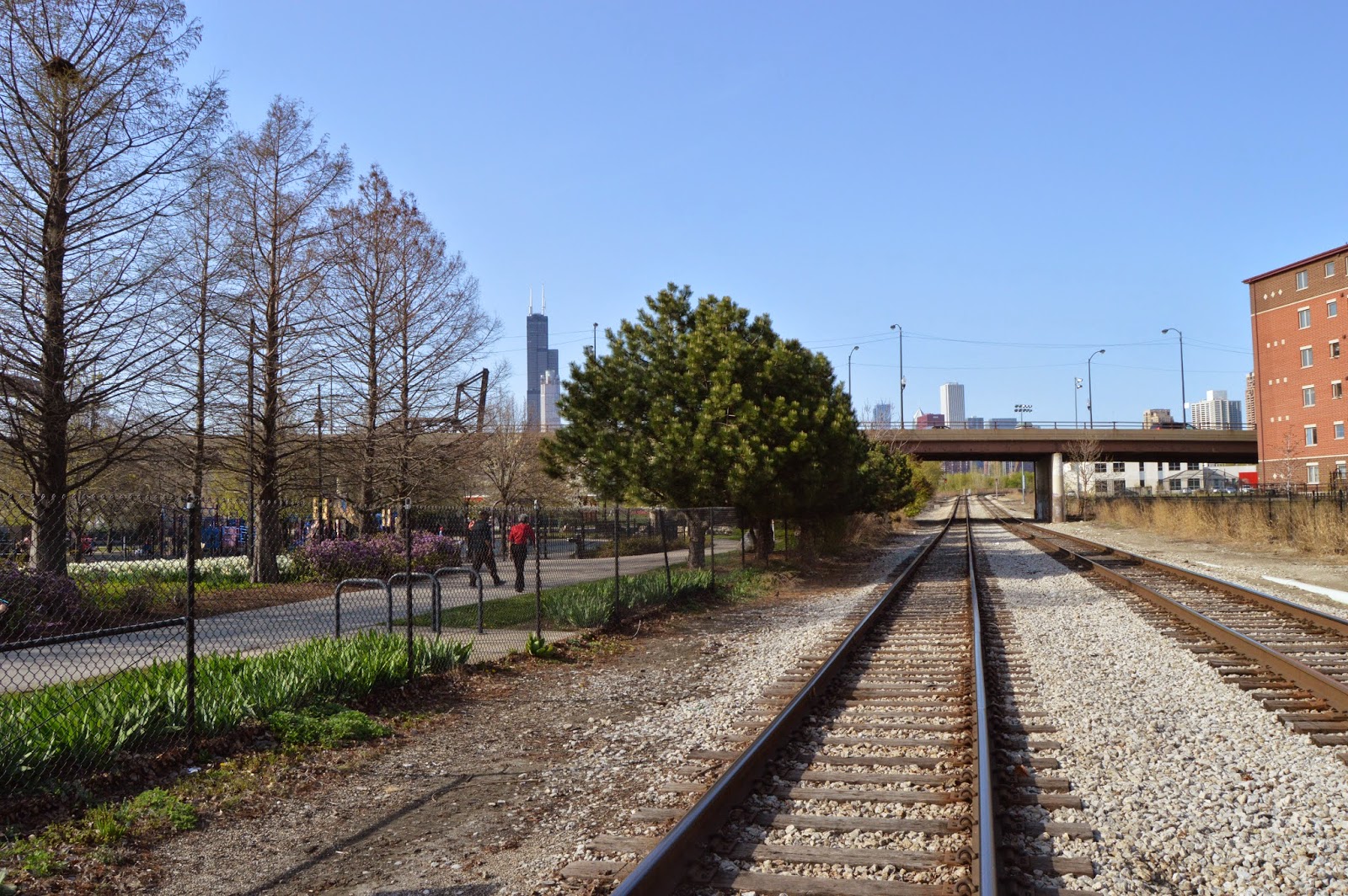
When I got to the tracks, I took a picture looking North. Most railfans are really engine fans. But as you can see, I'm actually a fan of rail. It looked well maintained. At the end of the entrance way, I took five pictures starting with a look back at the entrance way (East) and then looking Southwest, West, NNW, and North.


Actually, I took these five pictures at the end of my stay when I realized it would be a better way to understand the layout of the park. The tall black building in the background of the two northern pictures is the  Sears/Willis Tower.

There is quite a bit more park north of 18th Street. From a spot looking south at the 18th Street Bridge to provide orientation with the rest of the park, I took a picture to the North.


The main reason for going to the park was to check out the views of the Canal Street RR Bridge and St. Charles Air Line RR Bridge. The views are good, but I need to go back during the morning for the Canal Street RR Bridge so that it is not back lit.


And I learned about the 18th Street Bridge. It is unusual because it is one long span rather than two spans that meet in the middle.


This view struck me as just plain old pretty. The canal wall that has boards instead of steel pilings is where the water taxi docs.


That "dot" in the middle of the River is indeed a duck. I wonder if ducks always swam in the river or if this means that the river is not as polluted as it used to be. Or it might simply mean that people feed the ducks here.


Update: I have a rule of doing field trips in Chicago to go only on weekends because of traffic and parking. But I violated this rule when I was up relatively early on a sunny day to get better pictures of the Canal Street RR bridge. Not only was the traffic on I-90 bad around 10am, the traffic was also bad when I came home on I-55. But there were plenty of parking spots left on the north side of Chinatown's parking lot, which is where I want to park anyhow.

20150513 1419
This time I noticed a statue of Ping Tom. The text reads:

Ping Tom Memorial Park was named in honor of the leading force behind its creation. Chinatown's most noted civic leader, Ping Tom. A lifelong resident of Chinatown, Ping Tom became president of several businesses in the community after earning degrees in Economics and Law from Northwestern University. In 1984 he and other business leaders formed the Chinese American Development Corporation. This private real estate firm transformed a 32-acre rail yard site into Chinatown Square, a one hundred million dollar residential and commercial expansion of Chinatown. Ping Tom was Founding President of the Chinatown Chamber of Commerce, a past President and Director of the Chinese American Civic Council, and an advisory board member of the Chinese American Service League. Ping Tom served as trustee for a number of important civic and cultural institutions. He was also an advisor to US Senators, Illinois Governors, and Chicago Mayors.    Sculptor LIAO HUILAN.

The other side of the pedestal was written in Chinese.

Below is a view of the park looking back at the entrance from the framing of the Pagoda-styled pavalion. Past the two columns is the crossing gates for the CN/IC railroad and the Orange CTA line that was built relatively recently to Midway Airport that uses the old Santa Fe passenger right-of-way past the 21st Crossing that is near the south end of this park.


I'm used to retaking pictures of bridges and dams. I learned that if you want to retake pictures of flower gardens, you had better do it quickly! I include an original May 2nd picture as well as a May 13th picture.


While on the topic of nature, my second visit encountered a family. I learned years ago that geese like areas next to water that have a clear view of the water. If there is plant growth along the water's shore, it is hard to determine if there are predators hiding in the growth. The big office parks in the far western suburbs had retention lakes that attracted so many geese that they became an issue. One year a couple built a nest in a green area in the parking lot and the employees soon learned to give it a wide berth because if you got too close, one of them would come running at you making a lot of noise and threatening to bite.

Both at work and in this park, you have to be careful where you stepped because of all of the "droppings." But the reason I took this picture was to record natures impact on the constructs of man. Not only is the bank lining coming up, a retaining wall on the far bank is collapsing.


MWRD posted
The Skim Pickens was pictured along the South Branch of the Chicago River this morning near Ping Tom Park. Our trash collection boat operates along the Chicago Area Waterways from mid-April to mid-October and after significant storms year round, unless weather conditions prohibit safe operations. Two debris collection boats improve water quality and the recreational experience for thousands of people canoeing, kayaking, boating, and enjoying the waterways.
[The St. Charles Air Line Bridge has been partially up for over a year because a new overpass is being built east of this bridge.]