Friday, January 25, 2019

Fulton C: Cuba, IL: United Electric Coal's Cuba #9 Mine

(Satellite information is below)

Larry Senalik posted
Strip Mine - probably east central part of the state based on the other pictures in this collection 10/24/1951
#sangamonvalleycollection
James Stine Well, it took me a bit, but we can tell you where and what’s here. 
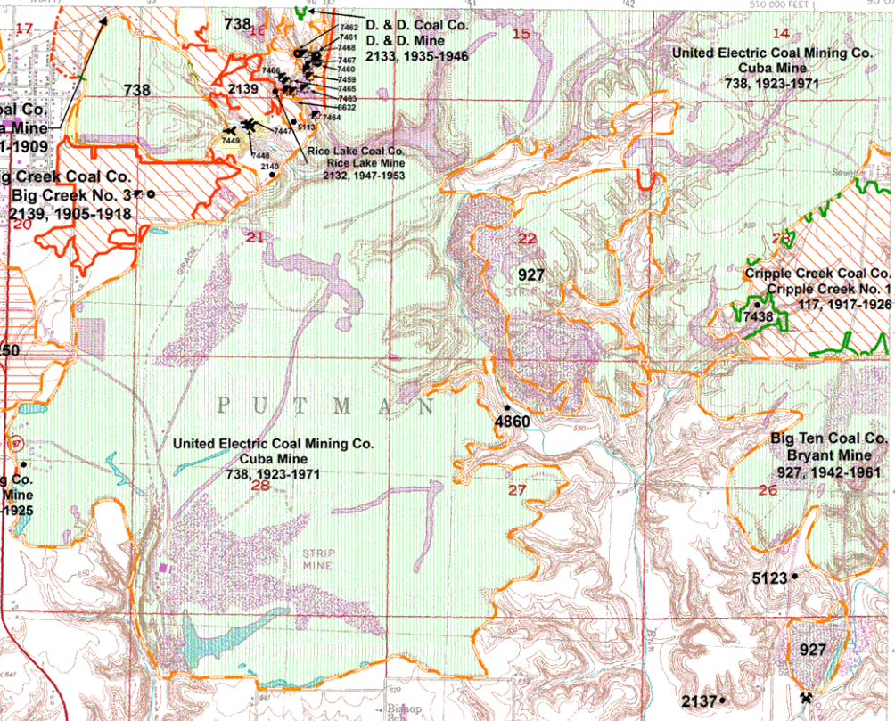
This is the United Electric Coal’s Cuba No. 9 which was located near Cuba, Illinois. The machines are a BE 950-B stripping shovel in the foreground and the W-1 Koble Wheel at the back of the cut or pit.

James Stine If you look in the upper right hand corner of this photo, I believe that’s another 950-B belonging to Truax Traer Coal and is their Fiatt Mine.
Alan Hummel That looks like County Route #5 and the TP&W [now  Keokuk Junction Railway] track at the upper end of the pit. Must have been in the late 50's.

One of several photos in a 1958 brochure provided by Charley Smart that describes the wheel excavator. 

Roger Kujawa posted
United Electric Coal Mine 9 Cuba, Illinois. Wheel excavator.
John Carson Great picture. When I was a child I remember stopping and watching a Wheel and Shovel pair work outside of Cuba Il. I remember seeing equipment like these mine along Il. Rt. 95 west of Cuba, and along the Canton -Cuba blacktop. I do not know if this particular Wheel and Shovel were the ones that were moved to mine the Banner Marsh area, but somebody knows for sure, I remember them sitting silent in a field near Banner, until they were disassembled and moved to the Industry Mine which was starting up. I met the gentleman who was an Engineer with Bucyrus-Erie, who was in charge of their reconstruction, and he showed me around several times during the process and I got to see the engineering blueprints. He told me that the Wheel originally started life as a Steam Powered Bucyrus-Erie shovel. Freeman United Coal Company came up with the idea for the wheel, which was a cooperative venture between B-E and Freeman. This wheel was either the first or second one. The thing that amazed me was this Engineer (I can't remember his name), was showing me these HUGE parts and explaining how this or that was worn out and had to be replaced. He knew them by sight to be good or bad. More amazing was Bucyrus-Erie had replacement parts in stock. I was up in the Cab of the Shovel several times while it was in operation. Nice little benefit of being a Deputy Sheriff on Night Patrol. As I understand, both the Wheel and Shovel from the Industry Mine were scrapped when it closed. . JCC

Justin Curless posted
United Electric Cuba Post Card Photo - Unknown Year: This Machine is Similar to another '' Wheel Machine" set up at the Fiatt Mine in about 1962.The back of the post card says . W-4 Kolbe Wheel Excavator , in operation near Canton, illinois. Constructed at United Electric's Cuba illinois,Mine,This 2100 ton Mobile giant was developed by Frank F . Kolbe. Powered by Electricity for overburden removal in open pit pit mining, it is this Nations largest in both size Capacity. Tall as a Fifteen story building and 420 Feet long,it's maximum capacity is 4,800 cubic yards per hour.

Justin Curless posted
United Electric Coal Strip Mine Excavator Cuba illinois 1950 S
Justin Curless posted
Shown here is one of the Cross-Pit Bucket Wheel Excavator Machines Built By The United Electric Coal Companies(Now Freeman-United Coal Mining Company).The one illustrated was Known as The W4 Kolbe Wheel,Named. after The Company's President Frank Kolbe. It Started work at the Cuba Mine in Illinois in 1959,and Could excavate at the tremendous rate of two million Cubic yards of overburden per month. The'Cross Pit Bucket Wheel excavator had its Discharge boom fixed in the same position as the digging Boom.
Kent Beckner THEY DEAD HEADED IT CROSS COUNTRY T0 BUCKHEART MINE .I BELIEVE IT WAS 1967 IT WENT TO THE SOUTH PIT WITH THE 1650

Justin Curless posted
Kolbe Wheel-Near Cuba
Roman Keating Any mines still operate in Illinois?
Myron Dudenbostel Peabody's Gateway Mine at Coulterville, Carter Coal has several underground and strip mines in the area also.........
Lennie Hanner I work at Prairie State Generating Company's Lively Grove underground mine, in Washington County, near Marissa.

Pat Willard W-4 on it way to Buckheart mine.

Bill Richter Pat i have a full page out of daily ledger showing w4 crossing route 78


Justin Curless shared Stine James' photo
In Jan. of 1959, at the Cuba Mine of United Electric Coal, the Kolbe W-4 BWX began its work assisting the 950-B shovel which had worked the mine since 1941. The W-4 was built on the lower works of the old Marion 5600 shovel and was the largest of it's kind in it's day. The dia. of the wheel was 27 feet with ten 2.5 yd. buckets and spanned the cut some 420 feet. She could move 3500 yds./hr and weighed in at 2100 ton. I believe this machine was moved to the Industry Mine in the early 1980's and had the lower works of the first 1050-B installed on it for service there.

Bruce Weirauch's posting gives photo credit to Hedrick-Blessing

Bruce Weirauch posted
1959
Bruce Weirauch posted

Larry Senalik posted
Pana - 9/25/1950
no additional information on the photo
#sangamonvalleycollection
James Stine We believe this is United Electric Coal’s Cuba No.9 shops and prep plant.
lewistown from counties, p12

I started by finding Cuba on the Google Maps road map. I could tell by all of the long skinny lakes that there had been a lot of strip mining in this area. [MetaLandscars]

Satellite
The mine was opened in 1923 by building a spur north from the CB&Q line that ran from Galesburg to Havana. [Blog] The blog indicates the mine spur was west and south of Cuba. So I found a 1949 topo map that covered this area when the spur existed.
Havana, IL  1949   1:62500   after searching for Cuba IL
The mine spur left the CB&Q branch where the CB&Q track curved close to IL-97. So now that I know where to look, I found the 1938 aerial photos. 00rz05422 shows the mine spur leaving the branch. The one to the north is the one of interest and an excerpt is included below. It shows the land scars of strip mining already covering a significant amount of land.
1938 Aerial Photo from ILHAP
Below is a contemporary satellite image of the same area. A problem with strip mining is that it buries the top soil with subsoil. I've seen evidence with other old mines that trees seem to be able to grow in the infertile subsoil. And they hide the ridges left by strip mining. The oldest aerial photo since 1938 that I could find was 1988. And the land already looks like it does today. You can tell by the 1951 date given for the photo at the top of these notes that at least basic land reclamation regulations had been written by then. The top soil was saved and used to not only to restore the land along IL-5, but some of the land mined by 1938.
Satellite
At the bottom of the above 1938 aerial, we can see the CB&Q branch entering the frame. Below is a closer look at the prep plant. There is a small rail yard north of the plant. And, like a logging camp, they have built tracks to the North and East to access the active mining areas. The prep plant in the 1950 photo looks bigger than the one in this image.
Digitally Zoomed
The rail spur to the north was extended to give them access to the TP&W as well as the CB&Q. The coal mine was closed in 1971. [Blog] So the USGS has done a good job of updating the map to show the spur as abandoned. Their railroad connected to the TP&W in 1954. [David Jordan comment on a post]
Burlington, IA   1958 (1976 ed.)   1:250000   after searching for Cuba IL
It appears someone left a toxic waste holding pond. They build an earthen dam with the solid waste to hold the liquid waste. I assume the inside has been lined with clay and/or plastic to keep the toxic liquid out of the surface and ground water. Given the amount of land available around Cuba, I would have thought they would have built their school further away from the waste dump.
Satellite

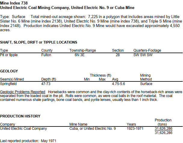
738 UNITED ELECTRIC COAL CO. CUBA 9 STRIP 1923-1971 FULTON 6N 3E 28  [index]

I presume that the grey numbers below are index numbers. I don't know what the black numbers are. The index entry above for #738 indicates section 28. But I see the index number in Sections 14 and 13. Green (blue on a different monitor) is abandoned strip mining, pink is abandoned underground mining, and yellow is indefinite abandoned underground coal mine boundary. We saw in the 1938 aerial photo above that mining began in Section 28.
Excerpt from Fulton County Mine Map
lewistown from counties, p i

Justin Curless posted, cropped and at posted resolution
Shown here in this Photo is a little Story of Coal Mining.
Cuba used to supply Wallace Power Station.

Roger Kujawa posted three images with the comment: "Old set of Postcards from United Electric #9 Coal Mine Cuba, Canton Illinois."
[At least the first one duplicates an image that is already in these notes. But it is worth repeating.]
Justin Curless shared
1

2

3

Justin Curless posted
United Electric Cuba Coal Mine Complments photo of Carlos Shaw
Montey Johnson I remember this move the highway had a dip in it from the crossing.

Bruce Weirauch posted
1965
[At Facebook resolution]

Bruce Weirauch posted
1 of 3
Alan Hummel Bruce, I couldn't find a date on this article. Do you know when it was published?
Bruce Weirauch Alan Hummel 65

Bruce Weirauch posted
2 of 3

Bruce Weirauch posted
3 of 3

Roger Kujawa posted
EARLY CUBA ILLINOIS Real Photo Postcard Strip Mine - United Electric Coal Mine
Roger Kujawa posted with the same comment
James Stine: I’m glad you got that Roger Kujawa. You beat me out on this one. This was the first stripping shovel to be mounted on crawlers. It a Marion 350. It forever changed the industry.


Monday, January 21, 2019

Franklin C: West Frankfort, IL: Old Ben #8 Coal Mine

(Satellite)

Roger Kujawa posted
Old Ben No. 8 Coal Mine Tipple West Frankfort Illinois 1939 View
Todd Stevens My Grandfather was killed at 8. He was the first man found near the shaft when rescuers made it in.

https://usminedisasters.miningquiz.com/.../old_ben_1947...


Dennis DeBruler The CB&Q branch over to Big Ben #9 passed to the north of this mine and had a spur into the south side of the mine. IC jointly owned the segment between #9 and #8. 
https://industrialscenery.blogspot.com/.../abanbncb...http://clearinghouse.isgs.illinois.edu/.../0bgm02017.jpg


John Mitchell The IC had trackage rights to their depot in West Frankfort from Cambell Yard (which was jointly owned by the Q and IC) but did not jointly own that line and they did not directly serve Old Ben #8. The Q "car hauled" IC cars to Cambell Yard.

Dennis DeBruler John Mitchell So did the Q own the track through West Frankfort all the way to Old Ben #9 and both railroads served #9?

John Mitchell That's correct and they jointly owned Cambell Yard adjoining #9. Also, the IC "car hauled" cars from Peabody # 18 to Cambell Yard for the Q. The Q delivered C&EI cars from #9 to the yard west of Orient #2's load yard. It gets very complicated and I wouldn't know a lot about it, but I did a huge amount of research, when writing my book, "The Q in the Coalfields".

Dennis DeBruler I'm going to look for that book. I noticed in the 2005 SPV Map that there were a lot of coal mines and railroads around West Frankfort. You can't get "car haul" info from a map.

Dennis DeBruler What was the name of the Q yard that caused a wide overpass to be built over I-57? The overpass still has BN signs on the side. That is what got me looking at West Frankfort in the first place. https://www.google.com/.../@37.8939742,-88.../data=!3m1!1e3

John Mitchell Among other things, I did more than 200 oral history interveiws with railroaders (active and retired), their families, coal company officials, and mine inspectors. I consulted hundreds of pages of maps and other documents from railroads, coal companies, and goverment agencies. I gathered around 300 photograghs. It only took me five years to put it together!

John Mitchell The yard west of town was just known on the railroad as "West Frankfort Yard".

Roger Kujawa posted
Old Ben No. 8 mine, West Frankfort, Illinois, IL, Farm Security Administration, 4

Roger Kujawa posted
Old Ben No. 8 Coal Mine West Frankfort IL Illinois 1939.
Roger Kujawa posted a different exposure
Old Ben No. 8 Mine,West Frankfort, Illinois, IL, Arthur Rothstein, January 1939 ,1

David Cantrell posted
Old Ben Coal Corporation, Mine No. 8, West Frankfort, IL
--1931 Chicago and Eastern Railway Official Directory of Industries
 
Roger Kujawa posted
Old Ben No. 8 mine, West Frankfort, Illinois, IL, Farm Security Administration
Dennis McClellan: Was this south of Cleveland street close to highway 37?
Todd Stevens: Dennis McClellan it was. One building remains there.


hinton
"The Old Ben Coal Corporation was previously the Wilmington Star Coal Mining Company which was renamed in honor of Benjamin Franklin and Franklin County, Illinois, by DeWitt Buchanan. The name change probably occurred around 1912 or 1913."

west-frankfort from counties, p12

Where there is an abandoned coal mine, there is probably at least one abandoned railroad. In this case, it is the CB&Q coal branch that has left us a wide overpass on I-55. Near the upper-right corner of this 1938 aerial is the Aban/BN/CB&Q overpass of the UP/C&EI.

1939 Aerial Photo from ILHAP

We can still see where the CB&Q branch curved north and where the spur into the mine kept heading south.
Satellite
Update:
west-frankfort from counties, p i, 290%

johnston_city from counties, p i, 80%


Palestine, IL: INRD/IC Roundhouse and Railyard

(Satellite; no Street View on Lincoln Street)

INRD = Indiana Rail Road

Michael Murphy posted

Christian Goepel posted
Eric Powell If anyone ever goes tramping around back by the shops today - do it in winter. Plenty of Copperheads back there!
Mark Jones Eric Powell , that’s something about those copperheads ! I remember seeing them in Sou IN ( near Milltown ) on my Uncle’s Farm years ago— wouldn’t think they’d be that far north in Palestine, IL?!?
Eric Powell Mark Jones Agreed. I used to work for INRD and saw the photo one of our engineering guys took of a big one next to a pile of new ties. The front of the old engine facilities is where materials are stored now. I think the roundhouse location is all overgrown.
1939 Aerial Photo from ILHAP

Front Desk, Jun 2016

Richard Koenig posted
Palestine, Illinois
Here’s a view of the Illinois Central Gulf railroad yard in Palestine, Illinois. The view is toward the east from near where the yard office stood (though on the other side of the tracks). The Wabash River is about two and a half miles down the way at Riverton.
One image by Richard Koenig; taken in the winter of 1978-79.

The yard currently has quite a few cars. I wonder if that is storage or if they handle that many waybill cars.
Satellite

Sunday, January 20, 2019

Springfield, IL: Illinois & Midland/C&IM Yard and Pillsbury Flour Mill

(3D Satellite)

C&IM = Chicago & Illinois Midland

I have redundant notes. There is more information here.
Larry Senalik posted
Chicago & Illinois Midland (C&IM) Springfield Yard and Shops - May 29, 1952
#sangamonvalleycollection
[This is facing southeast, so the C&IM/Wabash Tower is in the foreground. As is the depot. On the left is the roundhouse.]
Gene Rebeck The scene remains surprisingly intact after all these years, except for what looks like the removal of a depot.
Jim Duncan Cool photo!!! A Wabash train is visible having just passed Shops Tower in lower right corner.

Mike Coker posted
Rick F Looks like a westbound Wabash train just cleared North Grand Ave crossing.

Larry Senalik posted

1939 Aerial Photo from ILHAP

Larry Senalik posted
Pillsbury and C&IM Springfield Yard - 6/4/1952
#sangamonvalleycollection
Ken Morrison Wabash/N&W/NS sweeping across upper third of picture, with Lanphier Park (baseball) upper leftRick F Also behind the top row of house is the B&O line and diamond across the C&IM with an interchange track on the southeast corner.
Ken Morrison Rick-I think what you're referring to is actually a C&A connector between the line from Peoria and the Chicago-St. Louis main. B&O never got further north than Union Station.Rick F The B&O used Ridgley yard as a terminal for the locals. This was a carry over from when they controlled the Alton RR, The property to the north of the tracks is for sale still by the CSX corp. In later years when the B&O had trackage rights on the N&W, they would head north on the C&IM to Ridgley yard. This continued till they no longer had service to Springfield.

safe_image for Flickr
C&IM roundhouse and yard. Lots of gems in this image. Continuing to enjoy the wonderful photos in Sangamon Valley Collection of Springfield's Lincoln Library, from Larry Senalik.
Stan L. MaddoxAuthor This later view does an excellent job of illustrating the location of the old roundhouse radials, with the juxtaposition of the later Diesel-era Shops buildings. https://www.flickr.com/.../in/album-72157642065465955/
Kam Miller In the upper left of the photo is a steam engine running either tender first or pushing a small train south towards the connection with the Illinois Central, seen in the upper right.

Mike Breski posted
CIM, Springfield, Illinois, 1959 Chicago & Illinois Midland Railway Peoria-bound train is readied for departure at Springfield, Illinois, in August 1959. Photograph by J. Parker Lamb, © 2015, Center for Railroad Photography and Art. Lamb-01-054-05

Paul Jevert shared
C&IM 2-10-2 Texas type at Springfield, Illinois

Mike Breski posted
CIM, Springfield, Illinois, 1959
Chicago & Illinois Midland Railway Peoria train awaits clearance to depart Springfield, Illinois, in August 1959. Photograph by J. Parker Lamb, © 2015, Center for Railroad Photography and Art. Lamb-01-054-06
Rick F #51 is a SD9.. all the C&IM had at that time of this photo was 5 SD9s and 6 SW1200s.
[The Shops Tower is on the left.]

Curtis Mann posted
A view of the C & I M railroad yard taken from the top of the Pillsbury Mills plant probably sometime in the 1930s. The area east of 19th Street and along North Grand Avenue is shown.

Rick F shared
Rick F One interesting note about the roundhouse and powerhouse in Springfield. The railroad had to push the coal cars thru the roundhouse to get to the powerhouse to dump the coal. They would line up the turntable with a lead track and a stall that had a back door on the roundhouse so they could position the cars on the track beside the powerhouse.

Bob Rusciolelli posted two photos with the comment: "Was given this old photo by a now former employee of the I&M in Springfield. C&IM showing off their 50 units in the C&IM yard. In the background is Pillsbury when it was going strong. No date on the photo, but guessing it had to be back in the 50's. I do not ever remember the Pillsbury name being on the grain silos."
Kevan Davis Pillsbury was on there in the 70's.
Bob Rusciolelli Yes, but this was not the 70's. Pillsbury sold out in in 1991. Since they are showing off the 50 units, I'm guessing that it could have been in the 50's.
David Jordan Pillsbury opened this plant in 1929. Cargill operated the flour mill in its last decade, 1991-2001.
1

2


Doug Wolfe posted seven photos with the comment: "Old Pillsbury Mills Plant in Springfield, Illinois. Federal EPA Superfund site."
David Lasley Pillsbury sold to Cargill who used the mill, closed it and finally sold it to a crook who illegally ripped out the miles of copper etc. creating the asbestos mess. He declared bankruptcy (was finally jailed) and we the taxpayers are left with a superfund abatement site next to a residential neighborhood.
1

2

3

4

5

6

7

Larry Senalik Flickr via a Larry Senalick post

Larry Senalik Flickr via a Larry Senalick post

Larry Senalik Flickr via a Larry Senalick post

Larry Senalik Flickr via a Larry Senalick post

Jon Gordillo posted three photos with the comment: "X32 steam crane which is now at the Monticello railway museum.  Springfield 1974 by Ed Gordillo."
Paul Jones: Too bad someone stole the signs off of it while it was sitting out in the open at Monticello.
[That would explain why I could not find it in a satellite image. They are forced to hide it in a building. This is another example of a bad apple railfan spoiling something for everyone.]
1

2

3

Phillip Prior posted 13 photos with the comment: "Shops pics from the 90's."