Thursday, February 29, 2024

Cedar Point, IL: Lost/Milwaukee/Ohio & Gulf Depot and Coal Mine #5

Tracks: (Satellite)
Tailings Pile: (Satellite, the pile is gone.)

This was on the Milwaukee route that went to Streator, IL.

Andy Zukowski posted
Ohio And Gulf Railroad Station Depot At Cedar Point, Illinois. In the foreground of the card there is track switching post. In the background is the coal mine in tipple.

Directory

Dennis DeBruler commented on Andy's post
The mine operated from 1906 to 1924. The tipple had been removed by 1939, but the tailings pile still existed.

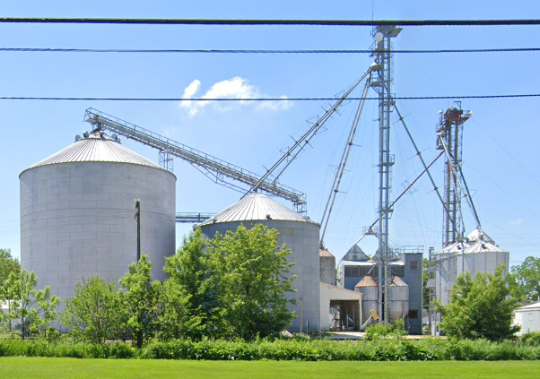
The grain elevator on the right side of the photo at the top survived.
Satellite

Street View, Nov 2022

Oconomowoc, WI: 1896 Preserved/Milwaukee Depot

(Satellite, 530 photos)

Street View, Aug 2023

Floyd Rose posted seven photos with the comment:
From a Depot, to a Business: Oconomowoc WI. Waukesha Co. Built in 1896, for the Milwaukee Road, designed by the famous Chicago architect, Charles Sumner Frost, in a Tudor Revival style. It is currently believed to be the only remaining Granite Stone depot still standing. As the Milwaukee Road crews were building West toward the Pacific, they were instructed, as they were blasting tunnels through the Rocky Mountains to load flat cars with the most colorful rocks found, they would be used in building this Depot. It probably didn’t hurt, that the president of the Milwaukee Road at that time, Albert Earling, lived on Oconomowoc Lake. Passenger service ended here in the early 60’s. Canadian Pacific freight, (Watertown Subdivision) and Amtrak service continues today, but this location is not a Amtrak stop. Today it’s a popular restaurant, where the main dining room, originally the covered waiting pavilion, is now seating for diners to watch as the trains go by. There are many railroad pictures and artifacts, plus an HO scale Oconomowoc layout located Inside. Along next to the depot is a 1923, Northern Pacific passenger car, now used as the Victorian Railcar Banquet & Catering car, also owned by the restaurant and a restored railroad passenger umbrella shed, built in 1906. This unique stone depot is on the National Register of Historical Places.
My Photos are from 07/23/2006, 08/16/2009, 03/26/2020 and 09/21/2020. Dec. 1963 Slide, by unknown photographer. fmr
Jim Kelling shared with the comment: "Oconomowoc Wisconsin (Milwaukee Road)
Amtrak’s Empire Builder runs through here without stopping."
1

2

3

4

5

6

7

The depot's location is marked on the map.
1959 Oconomowoc West and East Quads @ 24,000

Potomac, IL: Lost/IC Depot and Old Wood Grain Elevator

(Satellite, west of Vermillion Street. The depot was south of the tracks, and the elevator was north of the tracks.)

This town was on the IC Branch of Havana, Rantoul and Eastern Railroad (HR&E). A 1939 topo map shows it going all the way to the Indiana border, but a 1957 topo map shows the branch terminating in Potomac.

Andy Zukowski posted
Railroad Depot Potomac, Illinois. Possibly the Illinois Central Railroad 1921
Grayson Warbritton: Definitely IC as that was the only railroad through Potomac.

1940 Aerial Photo from ILHAP

On a satellite image, I could not find any remaining ag support industry. That is rather unusual for a town of this size in Illinois.


Wednesday, February 28, 2024

Stuttgart, AK: Cotten Belt Depot and Rice Mill

Depot: (Satellite, the land is now a parking lot for trucks for the mill.)
Mill: (Satellite)

Paul Luchter posted
Stuttgart, Arkansas (Cotton Belt)

The buildings in the background in the depot photo caught my eye. It turns out it is a huge rice mill.
Satellite

The depot was on Harrison Street southeast of the tracks and west of Grand.
1939 Stuttgart Quad @ 62,500

This aerial photo verifies the topo map correctly marked the location of the depot.
Mar 6, 1966 @ 14,400; AR1VBDQ00010143

The depot would have been where these trucks are parked. Note that the buildings in the background of this view match the buildings in the background of the photo.
Street View, Jun 2014

Cato, WI: Old Wood Grain Elevator

(Satellite)

The abandoned C&NW RoW is on the right side of this view.
Street View, Sep 2009

Debi Duford posted
Old grain mill in Reedsville Wisconsin.
Jim Stanelle: Actually in Cato?
Shannon Wagner: Jim Stanelle Yes it is, right off of Hwy 10

It appears they removed the homes that were along US-10 when it was expanded to four lanes.
1954 Reedsville Quad @ 62,500

South Haven, MI: The Black River is, in fact, black.

(Satellite)

Radiant Landscapes Photography posted three photos with the comment:
I love watching the colors of the lake and river change! Yesterday was a nice sunny day, and it was perfect to show the contrast and water colors. 
Explanation: 
The river is black from tannins and dead leaves present in the swampland upriver. There is minimal to no agricultural runoff at this time since it hasn’t really rained/snowed in a few weeks. It is not black from pollution. 
The water near the beach is greenish/blue/tan from the clay banks that exist north of town, and get carried south during a north wind. 
The blue water is just good ole Lake Michigan blue 😍
Enjoy and thanks for sharing!
Lisa Palanca: Zebra mussels also contribute to that clear blue/green water.
1

2

3

A satellite image also shows that it is rather black.
Satellite

I fired up Google Earth and went through the timeline. Most of the images had a black river. In one, it was just brown.


Tuesday, February 27, 2024

Frelsburg, TX: LCRA Cummins Creek Lignite Coal Mine and Bucket Wheel Excavators

(Satellite???)

LCRA = Lower Colorado River Authority    This Colorado River is in Texas instead of between California and Arizona. And according to a label on Google Maps, the Colorado River is also named Cummins Creek.

4 of 94 images shared by Steve Kole that are in his "LCRA Cummins Creek Lignite Coal Surface Mine-1988" album.
a

b

c

d
[The three Bucket Wheel Excavators are relatively small because long conveyor belts are used to carry the dirt to the other side of the mine and the coal to the power station. After each cut, the conveyor belts would have to be moved. The BWEs mine the top seam of coal and a dragline (" 8200 Marion Dresser Dragline (70 cy)") and haul trucks mine the lower seam of coal.]

I spent quite a bit of time trying to find the location of this mine. But the search results were mostly about water pollution, and I could not find an address in any of those results. I did find these brown spots near Cummins Creek. And when I zoomed out to find a nearby town (Frelsburg), I kept finding more and more brown spots. The Facebook post mentions the town of Ledbetter, which is further northwest. Cummins Creek is just west of Ledbetter. But I could not find any evidence of strip mining in that area. Maybe Texas improved their regulations for land reclamation. If you know the location of this mine and/or its power station, please leave a comment.
Satellite

Malvern, IA: Trail Head/Wabash Depot

(Satellite)

This Wabash route must have been Jay Gould's attempt to get a share of the transcontinental traffic on the UP.

Dennis DeBruler commented on the post below
Judging by the big green door, the building has been preserved as a trail head building, https://maps.app.goo.gl/YAWqdFNayXDvWpSj8

Michael Emerson Avitt posted
Wabash depot at Malvern, Iowa. Year unknown.

And a couple of the old elevators are still standing. The ag support industries are along the Wabash route instead of the CB&Q route.
Street View, Oct 2021


Genoa, IL: Lost/Milwaukee Depot

(Satellite, see comment on aerial photo below.)

Larry Foht posted
The Chicago, Milwaukee, St. Paul and Pacific Railroad Depot
Genoa Illinois
Larry Foht collection :
Rory Peterson: Tallest train order board I've seen.
 
Because of the boxcar behind the depot in the photo, there was a house track on the other side of the depot. Thus I think it was in the southwest quadrant of the tracks and Sycamore rather than the northeast quadrant.
1939 Aerial Photo from ILHAP

Street View, Jun 2019

Mound City, MO: CB&Q Depot

(Satellite)

Street View, Nov 2021

Michael Emerson Avitt posted
CB&Q depot at Mound City, Missouri on May 21, 2005.

Along  the old right-of-way, there is a lot of ag service industry. In addition to grain storage bins, there are a lot of tall, white tanks and four white bins. With street view, I found a sign for "C&M Seed Center" on a road to the building with the white bins.
Satellite

I learned of Mound City when I studied Burlington Junction because it is on the same CB&Q tendril that went from Villisca, IA, through Clarinda, Burlington Junction and Mound City to Bigelow, MO.
1902 CB&Q via Dennis DeBruler


Monday, February 26, 2024

Croswell, MI: Pioneer Sugar Factory

(Satellite)

I knew they processed sugar beets in Colorado, but I didn't know they also did it in Michigan. I'm learning that agriculture in Michigan is a lot different than in Illinois and Indiana.

Street View, Aug 2018

Donna N Jay Kandler posted
Sugar Factory, what are all those stone like things?
Dennis Nickel: Foundation of the old beet shed.
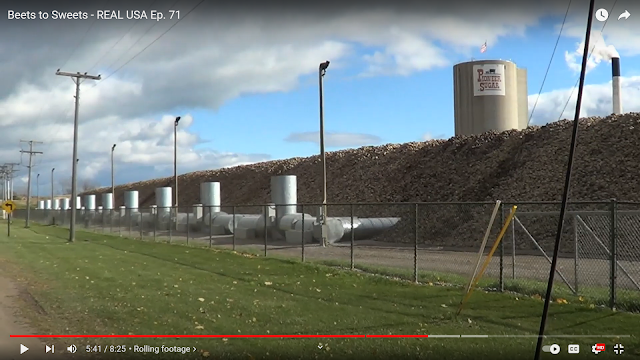
Paul Campbell: Those are concrete pylons. If memory serves me correctly they supported air ducts to allow fresh air flow through the piles of beets to keep them from spoiling. I seem to think there were fans, blowers, that forced air through the ducts, but it's been so long I don't recall for sure.

This shows the modern aeriation equipment.
 
8:25 video @ 5:41

Donna N Jay Kandler posted
Aerial view of Sugar Factory
Ralph Kinsley: Remember the summer night when it caught fire? [This was posted in 2021.]
 
Donna N Jay Kandler posted
Sugar Factory 1901
Linda Lofton: Yes, the aromas that came from the sugar factory were soooo bad in the fall, don't think we could ever forget

Donna N Jay Kandler posted
Sugar Factory 1902
 
Donna N Jay Kandler posted two photos with the comment: "Sugar Factory being built 1902."
Ralph Kinsley: Much of that equipment was steam powered and imported from Germany. The huge belts were difficult to replace and maintain and were prone to breaking and slapping workers down.
Tylor Hillman: Ralph Kinsley much of the brand new stuff we get still comes from Germany.
1

2
 
Carla Manska posted
Sugar Factory 1907
Darin Kronner shared


Donna N Jay Kandler posted
Sugar Factory 1909
 
Donna N Jay Kandler posted
Sugar Factory around 1910
 
Elaine Luck posted
Croswell Michigan. Sugar Factory.
David Cenci: A good chunk of the original plant is still in use.
Diane Laurent Niles shared
Roger Groot: Read from The Sugar Association in Washington,DC."Behind the secret of the sugar industry was hiding a ground breaking study published in JAMA INTERNAL MEDICINE in September 2016 has implied that for nearly 60 years the sugar industry was hiding a major secret.The report revealed that the Sugar Research Foundation now known as the Sugar Association was responsible for secretly paying nutrition scientists to publish findings that would transition the cause of heart disease from sugar to fat and cholesterol,reported the NPR.
Daniel Holthus: Roger Groot and according to science and doctors, sugar is one of the worst things that you can ingest. If feeds cancer for one.
Lori Nye shared
Pioneer Sugar factory, Croswell, Michigan

Donna N Jay Kandler posted
The Sugar Shack 1952
Bat Meneghin: The sugar bags were stored this way until the last 1980’s. It was all hand labor except for the conveyor belt. [I wonder what a bag weighs.]

Linda Hill Brown posted
Sugar Factory Lab
Dave Groh: I saw this picture somewhere else said 1902.

Donna N Jay Kandler posted
Sugar Factory 1910 from the Yale Expositor,

If the piles are processed in four months, what do the employees do the rest of the year?