Normally, I put the county name in the title of a coal mine, but this town and mine straddled two counties: Williamson and Saline.
A photo of the Marion 5561 shovel and the B-E 1450W dragline.
 |
| James R Griffin Sr. posted Will Scarlet 5561 getting out of water hole after pump is moved. |
 |
| James R Griffin Sr. posted Robbins parting drill at Peabody Will Scarlet mounted in TD International Dozer. Water injection tank mounted on side and bottom picture shows why it was mounted. Dust system that came with the unit leaked more than it done good. |
 |
| Raymond Barr posted Location is East of US Rt. 45 between Carrier Mills and Stonefort in southern Saline County. Danny Jeanna Gibbs: That photo is the 1450 drag line with a Robbinson drill on the highwall, worked in the warehouse mid 1978 until June 1982, the shovel was a 5561 and pit 16 had the 7200 , awesome group of employees and bosses |
John P. Kohlberg posted two photos to a Big Four group.
 |
| 1 |
.jpg) |
| 2 |
 |
| James R Griffin Sr. posted Photo of pit from June 1975,Peabody Will Scarlet-5561 and 1450W in distance. The Marion Mark drill getting power and 151 High cab loading Davis seam of coal. One move of Dekoven is in the bottom of picture. [Several comments discuss why this pit looks so "rugged."] |
.jpg) |
| Phil Elkins posted Dennis DeBruler: Pit #12 of Northern Illinois Coal Corp. had Marion equipment. So I do wonder where this pit was in Illinois. https://towns-and-nature.blogspot.com/2019/06/wilmington-il-northern-illinoispeabody.html Job Wilson: Dennis DeBruler Will Scarlet was located in Southern Illinois near Marion. |
 |
| Phil Elkins commented on his post |
 |
| Dennis DeBruler commented on Job's comment Thanks for the name of the mine. https://maps.app.goo.gl/suGKwV1zYcXR6uFM9 |
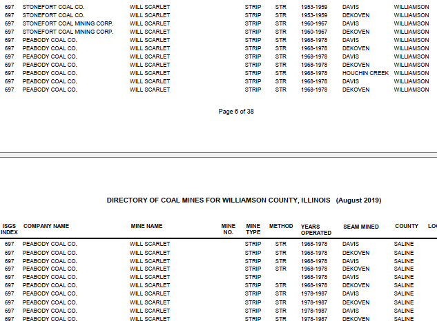 |
| Directory |
 |
| Map |
 |
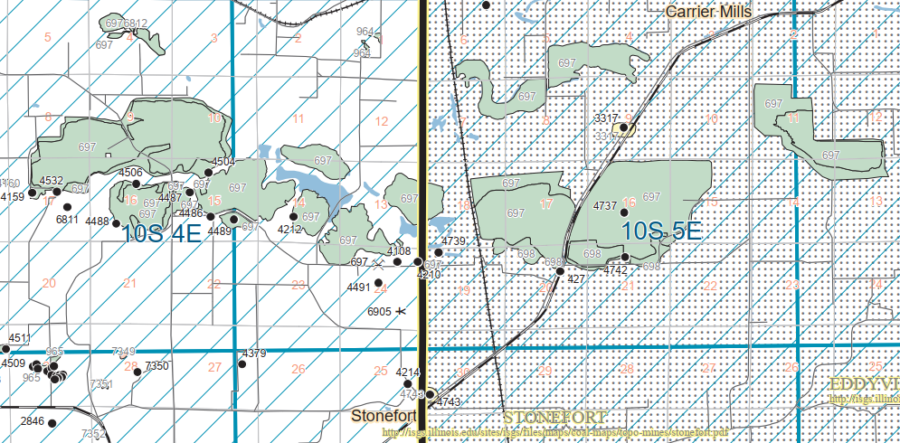
| ISGS Quad |
 |
| 1961 Carrier Mills and Stonefort Quads@ 24,000 |
Once again, the land tattoos of long artificial lakes show where the mine was.
 |
| Satellite |
Both the above topo map and this aerial show that, even though the industrial spur came close, it did not also connect to the IC. The spur went south and connected with the now abandoend Big Four's Egypt route in Stonefort.
 |
| EarthExplorer: Mar 18, 1959 @ 17,000; AR1VSJ000020081 |
The wastewater ponds are even more colorful than those of coal-fired power plants.
Those wastes are now being studied as a possible source of "rare earth elements (REE) and other metallic elements such as cobalt, nickel, lithium, manganese and zinc." [mining, smenet]
 |
| Satellite |
Those wastes are now being studied as a possible source of "rare earth elements (REE) and other metallic elements such as cobalt, nickel, lithium, manganese and zinc." [mining, smenet]
No comments:
Post a Comment