Sunday, December 31, 2017

Chattanooga, TN: The Great Flood in 1867 and Walnut Bridge Construction

One of the interpretive signs on the Walnut Street Bridge.
20171217,18 9060

Right insert in above sign

Left insert in above sign
The text reads:
On March 7, 1867, the Tennessee River began to rise at the rate of one foot per hour. Chattanooga experienced floods every spring, but this one, later known as the Great Flood, continued to rise until March 11, when the waters crested at 57.9 feet above low water levels. The second day of the flood sent the Meigs Military Bridge (minus the stones from the Bluff Furnace walls) floating downriver, and by the fourth day, all but the highest ground in the city was under several feet of water. The inset photograph on the right, taken from Lookout Mountain, shows Chattanooga under this, the greatest flood in East Tennessee's recorded history. The bottom left of the photograph shows the part of Moccasin Bend which stood above the water. Above that (to the North) is the top of Cameron Hill, and to the east of this is the high ground which bounded, roughly, by the bluff and today's McCallie Avenue.
This flood (and two others in 1875 and 1886, both of which were more than 50 feet above low water levels) convinced the city, when rebuilding, to significantly raise the levels of Chattanooga's streets. In some cases, current street levels are as much as ten feet higher than those of the last century. But even with today's street levels, a flood on the scale of the Great Flood would reach the second level of many buildings on Market Street.
After the loss of the Meigs Bridge, ferries were again the only means of crossing the river. This remained the case for more than twenty years, until the Walnut Street Bridge was constructed. After a considerable delay because of contracting difficulties, construction finally began in July, 1889. The contractors built a wooden cofferdam that stood above water when it was placed on the riverbid. When the water was pumped out of the cofferdam, excavators removed sand and gravel to reach bedrock. When this was accomplished, masons constructed the piers on the dry riverbed. In one location, the contractor's pumps were not strong enough to draw all the water from the cofferdam, and the city had to loan their fire engine to the construction effort. For two days the engine pumped out water while floating on a barge that, were it necessary, could take it back to shore to fight a fire.
In June, 1890, four of the six piers were finished, and work on the superstructure began. Nine months later, the Wlanut Street Bridge was officially opened. A large crowd attended the celebration, and the city was proud of this new link to the north bank of the river. Local boats, like the J.C. Warner (inset photograph at far left), could easily navigate the 320 foot spans, and water levels were never likely to get high enough to prevent boats from passing.
The Walnut Street Bridge established the first permanent link between Chattanooga and the rest of Hamilton County, and for the first time in seventy-five years, ferries stopped crossing the Tennessee to land to Ross's Landing.

Wednesday, December 27, 2017

Carmal, IN: Monon Depot

(3D Satellite)

Will Hazen posted four photos with the comment:
The Carmel Indiana Monon Railroad Depot. Built in 1883 by the Monon Railroad, the depot served as a passenger station until 1961 and freight station until 1974. Following preservation in the 1980’s, the depot now serves as the museum of the Carmel Clay Historical Society, with a small addition constructed on the south end. 12-24-17
1

2

3

4
The Monon depot was built close to the tracks, which ran where the Monon Greenway Trail is now.  It was moved 50 feet west to its present location in 1980 after donations from school children and many other people could pay for its relocation and restoration. Today it serves as the Carmel Clay Historical Society’s Monon Depot Museum. [CarmelClayHistory]


Chicago, IL Depot: IC+CSS&SB+MC Kensington (115th Street) Station

(Satellite, Street View)
When I think of Kensington, I think of the station that serves the electrified commuter trains of the CN/IC and the South Shore. The South Shore leaves the IC tracks just south of here under the control of the Kensington Tower. But the NYC's Michigan Central used to leave the IC tracks just south of the station to head to Indiana. And both IC and MC intercity trains used to stop here. From the comments below we learn the depot had two platforms, the one on the west, still used, was for commuters (suburban) traffic and one further east was used for the intercity trains.

1915 photo

Bill Molony posted
New York Central class J-1e 4-6-4 Hudson-type #5338 enroute to Detroit with NYC train #30, The Twilight Limited, on the Illinois Central tracks at Kensington in August of 1946.
Paul Petraitis Kensington had two stations the platform there on the left and the track level one just to the east where this guy is headed...the "other" station was block off about 1967 and still sits there waiting for an urban archeologist!
Bob Lalich Are you referring to the South Shore's freight station at the foot of the tower?
Mitch Markovitz Bob Lalich At Kensington, on the upper elevation, there was the high-level platform on the west for the electric service, and to the east, between the main-line passenger tracks was a low-level platform to serve the long-distance trains. One may still see the covered stairway to the east platform to this day. The South Shore Freight platform at street level on the south side of 115th Street, from Griffin Crossover was the original Lake Shore Passenger station. I don't think it ever served more than a freight crew washroom and some storage.
Bob Lalich I had forgotten about the intercity platform Mitch. Any idea when it was eliminated as a stop?
Mitch Markovitz Bob Lalich I'm going to have to do some Official Guide searching to be exact. My guess is 1958. That's when two of the three St. Louis trains were withdrawn, including the Night Diamond which was the last intercity train to stop at Matteson. Also this may have been the time when all Michigan Central trains were re-routed to LaSalle Street Station. I know the validator die for tickets stated, "Ill Cent Mich Cent CSS&SBRR until the end of validators.
Bob Lalich commented on the above posting
Here is a portion of a 1928 drawing of the Kensington station area showing the different platforms for suburban and intercity trains.
Steve Lewandowski posted
[This is looking south from the Kensington Station.]
Wayne Parker Those overhead wires veering to the left—South Shore Line.
Dennis DeBruler So that would be Kensington Tower in the background.
https://www.google.com/.../@41.6862007,-87.../data=!3m1!1e3
Mitch Markovitz For the kids just tuning in to our show, Kensington was at one time a stop for through trains. The station had a baggage elevator, and that stairway at the left accessed the platform.
Steve Lewandowski Are you referring to the station across the tracks? Sorry but my ignorance will be evident.
Mitch Markovitz Steve Lewandowski Steve...Please don't feel that you're ignorant just because you asked a good question. Two tracks to the left is the railings and the concrete base for the through train platform. What's ignorant and pisses a lot of us older guys off is when some guy says, "My grandfather had the last Santa Fe in Kansas." It was from 1890.
William H. Tolliver Kensington! Roseland community and shopping area to the immediate west and Pullman factory and community to the east.

Steve Lewandowski commented on his post
[Steve posted this in response to a discussion about the engines on what is probably an IC transfer out of Markham.]


Was Webster Junction: TP&W vs. KBS/Milwaukee/CTH&SE

(The junction content has been moved here.)


Aurora, IL: EJ&E Depot and Frontenac Grain Elevator

(Satellite)
Milwaukee used trackage rights over the EJ&E between Joliet and Aurora. Milwaukee gave up on this route in 1949.

The Trail/(EJ&E+CM&G)/AP&J Bridge notes have more information on the right-of-way between Plainfield and Aurora.

This route between Joliet and Aurora was originally the Joliet, Aurora & Northern Railway. [Bill's comment] Kevin Piper posted a history and some images concerning this route.

Kevin Piper posted
This was the end of the line for EJ&E at Aurora, Illinois. At one time, the tracks continued past the depot and across the street. 9-11-65 LOUIS CERNY PHOTO/KEVIN PIPER COLLECTION
Kevin's caption concerning the continuation of the track appears to be wrong. Milwaukee left the EJ&E a few blocks south of here. Specifically, the Milwaukee (formerly the Chicago, Milwaukee & Gary) left the EJ&E and curved south just west of the Lake Street underpass, and then it continued west. But the EJ&E turned north so that this depot was closer to downtown. (According to the map and to the aerial photo, C&NW ran on Lake Street.) And there was a connection between the Milwaukee and EJ&E branches so that there was a wye where Milwaukee and EJ&E forked. Below I marked up a 1939 aerial photo with the convention:
  • Green: EJ&E+Milwaukee
  • Yellow: EJ&E
  • Blue: Milwaukee
  • Purple: the third leg of the wye
1939 Aerial Photo from ILHAP
(Update: see CM&G Water Tower for more information on how the CM&G route proceeded west of this wye.)

The EJ&E terminated with a small yard that included this depot south of Garfield Avenue. Most of the terminal area is now a soccer field.

1939 Aerial Photo from ILHAP

Update:
USGS 1950 Aurora North topo excerpt


Some comments on a post by Michael Crist.
Stuart B. Slaymaker What most fans don't know, is the C.M.& G., was an original stockholder in the Joliet Union Depot Co. Circa 1912.
Jeff Kehoe I've done a little research on the Gary's passenger service, and trains averaged only a tortise-like 12 mph!
Carl J. Marsico More info here

John Govi posted two photos with the comment:
I took these pics back in July 1980. This is the Frontenac grain tower that was located where the Elgin Joliet and Eastern Railroad crossed over at Ogden Ave. At this date and location, Ogden was a two-lane highway from Oswego to Rt. 59 (hard to believe today). The tower was fixture for many years, until they tore it down in the early 80's, when Fox Valley Villages took over much of the properties. Personally, I miss seeing the EJ&E passing through this area.

Dan Grobe shared

1


2

Dennis DeBruler commented on Dan's share
This is the crossing:
I included quite a bit of context in the topo excerpt because it has changed a lot.
1980 Aurora South Quadrangle @ 1:24,000
I wonder if ComEd buried their power lines or if they abandoned this corridor. I don't even know if they can bury lines of that voltage. Normally power lines of this size persist through the decades. In fact, they sometimes rebuild to a higher voltage.

This EJ&E map shows the Frontenac location.
Kevin Piper posted

Sunday, December 24, 2017

Fort Wayne, IN: Wabash and Erie Canal

In addition to the main canal going east/west through town, Fort Wayne had a feeder canal to the north to tap the St. Joseph River at a higher elevation.

Great Memories and History of Fort Wayne, Indiana posted
Great Memories and History of Fort Wayne, Indiana posted
Eric L Lucas I believe the canal was filled in and the nickel plate railroad was built on top. Does anyone know if that is right?
Christopher Rorick I do believe the canal and the railroad are the same starting in new haven then heads west.
Joy Bronson-mccrady Christopher Rorick Hi Chris, there is an historian from St Paul New Haven church named Ross Hockemeyer. He did some excellent writing on the canal. It used to run roughly along old Hwy 24 to the east. You might want to see if you can find any of Ross' writings on this. Very interesting fellow. He always owned and his family still owns property along the river and old 24.
David Shaw posted
Dock street. The north side of Columbia st. Also known as The Landing.
[During the canal days, this would have been the front of the buildings.]
Jeff Smith commented on David's posting
Here’s a map that shows how downtown Fort Wayne was configured in 1855 during peak of the canal era.

Rick Stabler posted
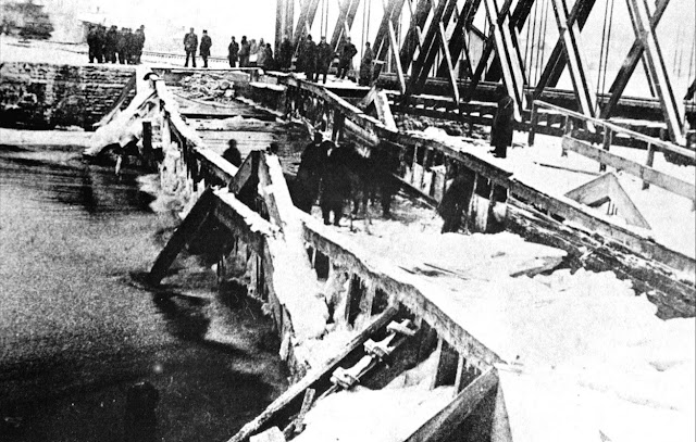
The remains of the Wabash & Erie canal viaduct looking west across the St. Mary's river after ice damage, circa 1888. The aqueduct was a 160 feet long water-filled trunk that passed floating commerce between America’s Eastern Seaboard and to the Mississippi River valley markets. To the east, and related to canal lore, is Fort Wayne’s smallest park, Orff Park. Marked by a statue of two young boys, it recalls the Aqueduct Club formed in 1912 in memory of those who made the canal aqueduct their swimming hole. ACPL online collection and History Center Notes & Queries.
Eric A Zerkle Looked pretty well trashed by 1888
Nancy Parker once railroad came in,not used,sold right of way to Nickle Plate in 1881.
Eric A Zerkle Think it was shut down in 1860.
Rick Stabler commented on his post
The canal ran under the railroad tracks and crossed the river on the southside of the present day railroad trestle.
[Satellite

Rick Stabler posted two photos with the comment:
The old stone mill (Edsall/Orff mill) at west Main street has been posted here before. Here is a neat drawing and description of how that mill operated in conjunction with the Wabash & Erie canal.
"Orff Mill had several names throughout its history. Sometimes called the “Edsall Mill,” it later was known as the “Empire” and commonly called “the old stone mill” when it stood while the machinery was operated by Wabash and Erie Canal waterpower. A pond was installed on the east side of the building that supplied water to the wheel on the southside of the building which flowed into a small basin that led to the river. The mill was built by Samuel Edsall in 1843. Milford Smith was an early partner and later the business passed on to Orff, Armstrong & Lacy, but John Orff afterward became the sole proprietor. Later his sons John Jr., C.E. and Montgomery Orff took control of the operation. In its final years the mill was powered by steam. It stood on east bank of the Saint Mary’s river near the “Let’s Go Swimming” statue." Saint Mary’s River Aqueduct No. 1 was built in 1835 and rebuilt in 1871. It carried the Wabash & Erie Canal across the Saint Mary’s until 1882. The wooden flume was two spans, each eighty feet in length, seventeen feet wide, four and one-half feet deep and was supported on three great stone pillars. The water of the canal was specified to be at least four feet deep and moved about five miles an hour through the aqueduct, at a weight of more than 450 tons.
A roof was built over the channel, giving it the appearance of a covered bridge. At the west end, just past the aqueduct, a large basin was created so that the canal boats could turn around or wait for another one to pass. It was here in the basin and in the aqueduct itself that the boys often played.
In 1881, the Nickel Plate Railroad purchased the canal right-of-way, including the aqueduct and erected the steel bridge for the trains that still stands today just north of the aqueduct’s location. The aqueduct soon collapsed into the river and was removed in 1883." -ACPL online collection and History Center Notes & Queries
Ben Klinger You can still see some remnants of the aqueduct just south of the railroad bridge.

1

2

Friday, December 22, 2017

Topeka, IN: Wabash Depot

(Satellite, Street View)
Richard Roberts posted two photos with the comment: "Wabash Depot and caboose in Topeka,IN."
They have preserved the train order signals. This is on the Wabash segment that has been abandoned between South Milford and Chicago.
1

2

Thursday, December 21, 2017

Chester, MA: CSX+Trail/B&A/Western Railroad Roundhouse, Coaling Tower and 1840s Depot

(Satellite: Roundhouse, Tower, Depot, no Street Views are available)

The 1928 RR Atlas shows this route as the Boston & Albany. The Chester Railway Museum indicates this segment was built by the Western Railroad. It was the world's first mountain railroad, and it was completed in 1842. It is now part of the CSX Boston Line. This mountain railroad went over the Berkshire Range of Western Massachusetts, and it used several cut-stone arch bridges. The route with the bridges was bypassed in 1912 and 7 of the 10 Keystone Arches are now part of the Keystone Bridge Trail. An example bridge is Whistler Bridge #4 (Bridge Hunter).
Photo from HAER MA-155-4 from ma1704
The variety of designs for coaling towers continues to fascinate me. The roof of the roundhouse in the satellite image is about half gone. It is good that Craig caught it in the 20th century while the roof was still intact.
HO Diesel Supply posted (source)
Conrail train symbol FRSE (Framingham,MA to Selkirk,NY) is in the company notch preparing to assault the Berkshire Mountains at Chester,MA. Late 90's. Photo by Craig Sturgeon.
Brian Sopke posted
Conrail train SESP rolls past the old coaling tower at Chester, MA on March 4, 1995. Carl Weber Jr. Photo, Brian Sopke Collection.


A 2012 visitor's log has exterior and interior views of the roundhouse and exterior views of the coal tower (about 2/3 of the way down the page).

Wednesday, December 20, 2017

Princeton, IN: Alliance Coal Loop and Gibson County Coal Mine

Loop: (Satellite)
Mine: (Satellite)

It loads coal from Gibson County Coal, which is an underground mine that produces low-sulfur coal. [gem]

An overland conveyor from the mine comes in on the right and up to a storage silo.
Street View, Sep 2022

In this view the loading tower was skunked by a train.
Street View, Jun 2012

NS/Southern goes across the south side of the loop and CSX/L&N/C&EI is on the east side.
Satellite

The concrete silo at the loop is just surge storage. The bulk of the storage is back at the mine.
Satellite

And it looks like coal is trucked in to be loaded on trains.
Satellite

Rick L Whitehead posted
Princton,Indiana
Loading Coal
N.S 7663 ES 40-DC
12-18-2017

It's nice to see that some coal mining jobs still exist in the Illinois Basin. According to the satellite image, this loading loop can receive trains from both the CSX/C&EI and NS/Sou railroads. On the satellite image you can follow the conveyor belt that delivers coal to the loading silo from Gibson County Coal, which is a little northwest of this loading loop.

Viral Media posted
Rail Loop Serving CSX & NS
In 2019 the Alliance – Gibson County Coal Rail Load-out Facility went into production. This is ideal for the shipper as it allow access to both CSX and Norfolk Southern rail networks which greatly extends their customer opportunities. 
Alliance is the 2nd-largest coal producer in the eastern United States. The mine in Gibson County is one of five mines operated by Alliance in the Illinois Basin Coal Deposit. Gibson County Coal, LLC operates the Gibson South Mine, located near the city of Princeton in Gibson County, Indiana. Gibson South is an underground mine and utilizes continuous mining units employing room-and-pillar mining techniques to produce low/medium-sulfur coal. The Gibson South mine's preparation plant has a throughput capacity of 1,800 tons of raw coal per hour. Gibson South in Indiana began production in April of 2014. Gibson North Coal Mine has been inactive since November 2019. 
The coal loadout facility is located 6 miles West of Princeton, IN on Highway 64 and includes the ability to unload trucks, blend coals, load 135 car unit trains in four hours and store over 4 million tons of coal. 
[The location has to be wrong. The loop is on the northwest side of Princeton along US-41. It makes you wonder about the accuracy of the other words that the AI spit out.]

I think this is the same facility.
Chicago & Eastern Illinois Railroad Historical Society shared
This is on the north edge of Princeton on the Evansville line. Both CSX and NS trains can access the loop.
IndianaRails photo
Evansville Western Railway, EVWR 2103 Rebuilt EMD GP40-3 loading a coal train at Alliance Coal Loop in Princeton, Indiana on February 9, 2019.
Eli Noble Their has been more and more of those up there.
IndianaRails Eli Noble I think there running about once a week maybe twice a week.
Jim Pearson Very nice Ryan! Good use of leading lines!

Frank Keller Photography posted
Evansville & Western 4501 is loading coal at the Alliance Coal Loop in Princeton, IN 8.5.18. This was a very unique operation as I recall both CSX and perhaps even NS loaded trains here.

SteelRails posted
CSX Transportation CSXT 914 GE ES44AC-H convertible was the DPU power for a coal train at Alliance Coal Loop in Princeton when the mine failed to move the coal loading chute off to the side. It dragged from one end to the other on 914 ripping off the cover over the cooling fan and the roof of the locomotive cab. The photo was taken in Princeton, Indiana on October 18, 2022 a week after the accident.
https://steelrails.pixels.com/featured/csxt-914-ge-es44ac-h-steelrails-photography.html
Leonard Wheland: SteelRails Do you know what rail line runs N&S pass that loading facility? I'm thinking it's the old L&N (now CSX) that runs from North of Vincennes through Evansville towards Nashville.

Dennis DeBruler commented on Leonard's comment
The NS route was the Southern. The L&N route was originally the Chicago & Eastern Illinois. The L&N got the east part when Missouri Pacific got the west part of the C&EI.
1959 Princeton Quad @ 1:24,000

SteelRails posted
https://steelrails.pixels.com/featured/1-csxt-914-ge-es44ac-h-steelrails-photography.html

SteelRails posted
https://steelrails.pixels.com/featured/2-csxt-914-ge-es44ac-h-steelrails-photography.html
Jonathan Lafferty: It's gonna have to Huntington shops to get fixed.


SteelRails posted
CSX Transportation CSXT 914 GE ES44AC-H convertible was the DPU power for a coal train at Alliance Coal Loop in Princeton when the mine failed to move the coal loading chute off to the side. It dragged from one end to the other on 914 ripping off the cover over the cooling fan and the roof of the locomotive cab. The photo was taken in Princeton, Indiana on October 18, 2022 a week after the accident.
https://steelrails.pixels.com/featured/csxt-914-ge-es44ac-h-steelrails-photography.html
Leonard Wheland: SteelRails Do you know what rail line runs N&S pass that loading facility? I'm thinking it's the old L&N (now CSX) that runs from North of Vincennes through Evansville towards Nashville.

Dennis DeBruler commented on Leonard's comment
The NS route was the Southern. The L&N route was originally the Chicago & Eastern Illinois. The L&N got the east part when Missouri Pacific got the west part of the C&EI.
1959 Princeton Quad @ 1:24,000

SteelRails posted
https://steelrails.pixels.com/featured/1-csxt-914-ge-es44ac-h-steelrails-photography.html

SteelRails posted
https://steelrails.pixels.com/featured/2-csxt-914-ge-es44ac-h-steelrails-photography.html
Jonathan Lafferty: It's gonna have to Huntington shops to get fixed.