Saturday, March 30, 2019

Chicago, IL: I. S. Berlin Press

(Satellite, even the Best Buy that was on the northeast corner is gone)

We have already seen Lakeside Press and Cuneo Press buildings. Chicago sure did do a lot of printing. This printing company was founded in 1919. It moved from printers row in 1949 and expanded in 1961 with a curved side to accommodate the ramp of the expressway that was also being built. "I.S. Berlin Press printed children’s books, advertising literature with colored pictures, and other products using the lithography process." [ChicagolandMuseumViews]

ChicagolandMuseumViews
Kathy Malawski Johnson posted the question: "Does anyone have a photo of the 'I. S. Berlin Press' building?"
Gilbert Jimenez I. S. Berlin Press at Kimball/Belmont. Closed 1977. Now the site of the former Best Buy and Below Zero store. 

That clock tower was iconic.

On 8/12/71 at 4 am, Playboy Bunny Lorraine Kowalski, 29, plunged to death from the 90th Floor apartment of Marshall Berlin, 45, vice chairman of the printing company. (In the Hancock Building [ForgottenChicago comment])
He said she "just fell through" the 1/2 inch thick double pane window of his apartment. 
An engineer said the windows could withstand 85 lbs of pressure per sq ft, with a 2.5 safety factor -- more than 200 pounds psf before breaking. 
Berlin refused to take a lie detector test.

WayOutWardell Flickr 1966 Photo

Northeast corner of Kimball & Belmont, A. Epstein & Sons, architects. Demolished in the late '70s and replaced with a shopping center.

As a kid, I was fascinated with the clock tower that was lit in blue.

Bel Bowl is visible in the background (on Belmont just before the expressway), which was replaced in the early 90s with a grocery store that quickly closed.

[Morning rush hour on the Kennedy or an accident?]

TrolleyBuses [ForgottenChicago comment]
Rand McNally has been printing since 1856 so this is another company's map.
The link has expired

Re: vintage photos of logan square / avondale
Posted by: fleurblue ()
Date: March 27, 2010 02:26AM
On the Northeast side of the Belmont/Kimball intersection there was a very large printing company, I.S. Berlin Press. I can't find any references on the net but I do remember it took quite a while to demolish the place as it was built for the weight of the printing machines. The building came right up to the sidewalks on both streets, as I recall.

A Flickr photo of the demolition

This building was demolished to make way for a shopping center because the company had moved to Carol Stream.
American Litho
As of May 2011, Berlin Industries, Inc. was acquired by American Litho, Incorporated. Berlin Industries, Inc. provides Web offset commercial printing services in the United States. The company produces catalogs, newsletters, self mailers, post cards, magazine and newspaper inserts, buck slips, and brochures. It also offers database management, prepress, printing and bindery, equipment list, and direct mail services. Berlin Industries, Inc. was formerly known as I.S. Berlin Press and changed its name in 1976. The company was founded in 1919 and is based in Carol Stream, Illinois. Berlin Industries, Inc. operates as a subsidiary of AO Smith Corp. [Bloomberg]

Thursday, March 28, 2019

Goodenow, IL: C&EI NE Tower, now called Balmoral

(Satellite, the thick part of the tree line on the west side)

Chicago & Eastern Illinois Railroad Historical Society shared
Kam Miller Or north end of double track? Reason I ask is because the bridge at Goodenow doesn't look wide enough to have been triple track. Used to have a girlfriend at Goodenow and would hang around there a lot.
Dennis DeBruler A Street View shows that there is room for a third span. (Facebook is not giving me the option of adding a photo, so here is a link: https://www.google.com/.../data=!3m6!1e1!3m4!1sqetN1xqikW...) Also, someone has converted the third track RoW into an access road south of Elm Court Lane with fresh rock.

Eric Berg posted
C&EI "NE" tower located just north of Goodenow, Illinois and just south of Crete. This was the North End of triple track, hence the name NE. The entrance to Lincoln Fields was here also, where all the passenger trains came from Chicago.
Dennis DeBruler I think the wide spot in the treeline on the west side is where the tower was: https://www.google.com/.../@41.4157044,-87.../data=!3m1!1e3
Phil Partenheimer Called Balmoral now.
Phil Partenheimer An old engineer , Clarence Hillard said he worked steam trains that would start downtown Chicago, pick up passengers at the all the stations and drop them off at the track.
Dennis DeBruler I know that back in the horse & buggy days, C&WI, B&OCT, EJ&E, etc. had passenger service because I've seen photos of some of their depots. But I'm having enough of a challenge trying to learn how freight trains worked in Chicagoland that I have been ignoring the old commuter services. Cemeteries, as well as racetracks, were big customers for those passenger trains.
Phil Partenheimer Only cemetery I can remember on our line C&EI, Union Pacific when I worked, was just south of Material Service in Thorton.
Dennis DeBruler There are two cemeteries down there next to each other: Homewood Memorial Gardens and Washington Memory Gardens. I wonder if the purpose of this abandoned connector between CN/IC and UP/C&EI was to serve those cemeteries and/or to allow IC to access the quarry business. https://www.google.com/.../@41.5606938,-87.../data=!3m1!1e3
Dennis DeBruler commented on Eric's post
1939 Aerial Photo from ILHAP
 I assume Lincoln Fields was a name for the race track. A 1939 aerial.

Dennis DeBruler commented on Eric's post
A closeup


Saturday, March 23, 2019

Sioux Falls, SD: Flood of 2024: The Falls

Flood of 2024  This is one of the flood incidents of 2024.

Satellite
[It looks like the river runs north through this town.]
The reason for these views of the falls is to provide some context for the 2019 video of the falls near the bottom of these notes. (Update: and the 2024 views.)

The falls typically are rather docile.
Samantha Riley, Aug 2016
Marco Flores caught a heavier flow in Sep 2018
An even heavier flow:
Bryan Preas, Oct 2018
And heavier:
Dennis Throckmorton, Sep 2018
Annette Noble also caught it during Sep 2018
Frank Park, just a month earlier, the flow was low
The flow is heavy enough that they have taped off the sidewalk to the observation platform and posted a warning sign.
Frank Park, Jun 2014
This photo shows why they put tape along the sidewalk. People are used to walking out on the rocks.
Brianna Titone, Jun 2017

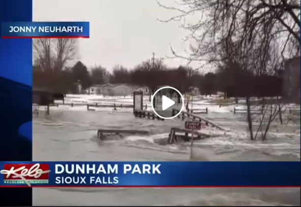
But after a bomb cyclone and lots of melting snow.
Screenshot
With the Big Sioux River at record levels, the water is rushing at Falls Park. See more scenes from this massive storm online: https://www.keloland.com/…/photo-gallery-major-m…/1845717943

I believe this is the sign we see in the observation area to which a sidewalk lead in the above photos. It looks like they had to tape off the entire park during this flow!
Screenshot @ -0:50

Update: Judging from the houses in the background, I think it was this trail bridge. It looks like the houses in the background are in water. At least the closer houses are on higher ground.
Screenshot

Ted Gregory posted eight photos with the comment:
Railroad bridge over Sioux Falls
Great Northern heritage
Big Sioux River
Sioux Falls, SD
1

2

3

4

5

6
(The last two photos are 360-views of the RR bridge.)

Ted Gregory posted four photos with the comment: "Deck plate girders over Sioux Falls    My pics     May 23, 2020."
1

2

3

4

Bob Gilreath commented on Ted's post
Well let’s just add a train for fun! My shot june 2023.

2023 was another wet year because of a big snow pack.
Frank Keller Photography posted
The falls of Sioux Falls the northbound crosses the bridge at Sioux Falls.

Aug 2021:
Frank Keller Photography posted
DAIR 2511 crosses Sioux Falls in its namesake city as they make their way south with a rock train. 8.30.21
.

Flood of late June 2024


Facebook reel, "Saturday" was Jun 22, 2024

Note that the record had been 37.7'. So it is 7.3' (2.2m) higher than it has ever been.
NOAA

A little further upstream at I-90, the flooding was just minor.
NOAA

kkac

Ben Davis posted

Friday, March 15, 2019

Was Streator, IL: BNSF/Santa Fe Depot

I already had notes for this depot. I have discovered this was a duplicate entry because I had not labeled the first set of notes. They are now properly labelled.

Saturday, March 9, 2019

Baring, MO: Santa Fe Coaling Tower

(Satellite, I don't know precisely where it used to be)

Bob Finan posted
Baring, Missouri. The coal chute along the Atchison, Topeka, and Santa Fe Railroad between Fort Madison, Iowa and Marceline, Missouri - 1943 - Jack Delano photo
Sam Bailey I have a series of photo's showing this structure being demolished. They used charges to drop it to the left in the photo. All rail was removed for a place to fall thus not damaging the material. Oddly enough though the ties were left in place..
Photos of the removal of the coaling tower from Santa Fe Curviving Coaling Towers

Wednesday, March 6, 2019

New Haven, IN: Wabash & Erie Canal Lock #2

(HAER (63 photos) via in0341; HAER photo listSatellite, evidently the south lanes of US-24 were built over the canal. According to some of the photos, it was located just east of where the ramp now joins US-24.)

Starting on Page 8 of the data file is a general history of the canal.

Tracy Seaman posted
canal locks they found where they were digging for 469?
Tracy Seaman Yep straight white oak and they didnt even remove the bark on ta lot of the trees.
Judy Herendeen They are now in Indy in the historical museum.
Nancy Parker Some of it,not as much as they took. Some was given to Wabash Historical society,some are reburied and some are going to be sliced to sell at Canal days and for display at NH Community Center.
[3. View from above the pool looking west from the east gate to the west gate of the lock, showing the collapsed lock gate at the east end, the breast walls and the double row of lock floor decking. - Wabash & Erie Canal, Lock No. 2, 8 miles east of Fort Wayne, adjacent to U.S. Route 24, New Haven, Allen County, IN [HAER-photo03]]
-  Significance: Lock No. 2 is an example of a wood lock, many of which once existed along the original line of the Wabash and Erie Canal. More fragile than those supported by dressed stone, locks which were constructed on either the timber frame or crib plan were subject to greater wear, deterioration and rot. Lock No. 2 provides an example of nineteenth century wooden lock technology. Engineered to provide a seven-foot lift, Lock No. 2 was one of three similar locks between Fort Wayne and the Ohio/Indiana state line. It was originally constructed between 1837-43 as a Timber Frame Lock (according to the engineer's report of 1837) and in 1849 it was rebuilt as a Timber Crib Lock, the latter being a sturdier type of wood lock construction. At least one additional major repair and/or reconstruction occurred. Lock No. 2 is locally known by the name of its former lockkeeper, Joseph Gronauer and his family. Their farm and store were located adjacent to the lock on the north side, throughout the years of its operation. The family farmhouse remained intact at the site until its demolition between 1942 and 1945. The 20-mile section of the canal within which Lock No. 2 is located, once formed a link between the Fort Wayne-Lafayette portion of the Wabash and Erie Canal to the west and the Miami and Erie Canal in Ohio, to the east. When it was finally completed in 1843, travel and commerce to the Great Lakes and the eastern seaboard, via Toledo, Ohio became possible for the citizens of Indiana. [HAER]


Becky Osbun posted seven photos from the HAER collection with the comment: "On October 3, 1992, an Open House was held at a Wabash & Erie Canal excavation site 8 miles east of Fort Wayne (adjacent to U.S. 24)."
Victoria Kruse This find shut down the construction of US 469 for months as the excavation to salvage these historic pieces of the Wabash and Erie Canal.
Nancy Parker should have kept it delayed longer and made safer exits.
Susan Bonnell Burns Last time I checked these beams were in the Indiana State Museum in Indianapolis.
Gary Keipper Much of the dirt from the lock was removed to a park in New Haven in a fenced in area. My brother and I and some others were allowed to metal detect and sift that dirt. My brother found an old 1700's Mexican or Spanish coin and a clay pipe was found. I believe that all we dug out of there is on display in City Hall n New Haven, although I have never seen it.
Nancy Parker there are also pieces of the lock at the canal museum at Wabash.
John VanHorn Our neighbor's garage attic floor is made with boards salvaged from one of the Gronaurs outbuildings.

42. Open house at the site, Saturday, October 3, 1992. View north/northwest. Photograph shows the lock support floor joists on sleepers and the mortised crib walls. The 1 inch board at the base of the crib wall is the pre-super construction 'footprint' for alignment.
https://www.loc.gov/pictures/item/in0341.photos.318662p/

Dennis DeBruler 43. A view from the north, looking south across the lock floor. Two layers of floor decking are visible at left, where part of the floor decking, damaged by telephone company intervention, has been removed.
https://www.loc.gov/.../item/in0341.photos.318663p/resource/

Dennis DeBruler 3. View from above the pool looking west from the east gate to the west gate of the lock, showing the collapsed lock gate at the east end, the breast walls and the double row of lock floor decking.
https://www.loc.gov/pictures/item/in0341.photos.318623p/

Dennis DeBruler 45. View along the length of the lock, from the east, looking southwest Oak shooks and carpet protected the resource from visitor traffic. A worker is 'watering down' the lock, to prevent damage from desiccation.
https://www.loc.gov/pictures/item/in0341.photos.318665p/

Dennis DeBruler 44. View looking northeast. The lock was emptied of guests periodically during the day so that the timbers could be sprayed down with water. The board walk was laid over the west miter sill (at center) to allow visitors to enter without damaging the sill.
https://www.loc.gov/pictures/item/in0341.photos.318664p/

Tommy Lee Fitzwater posted
Wabash & Erie Canal,New Haven,Allen County,Indiana,IN,Historic Survey,HABS,43


Dennis DeBruler 46. View looking west, toward west gate. Planks were laid in the mud (center left) so that visitors could view the inside of the south, forebay crib and examine the unusual right-handed counter foil. A visiting engineer perceived this as quite 'modern'.
https://www.loc.gov/pictures/item/in0341.photos.318666p/

Dennis DeBruler 60. Same view, showing technicians hosing down the timbers. Shortly after this photograph was made, the timbers were completely submerged in water, held down by heavy concrete castings.
https://www.loc.gov/pictures/item/in0341.photos.318680p/

Randy Harter commented on Becky's post

Drawing from HAER IND,2-NEHA.V,1- (sheet 1 of 4) from in0341

Drawing from HAER IND,2-NEHA.V,1- (sheet 2 of 4) from in0341

Drawing from HAER IND,2-NEHA.V,1- (sheet 3 of 4) from in0341

Drawing from HAER IND,2-NEHA.V,1- (sheet 4 of 4) from in0341
Rick Stabler posted four photos with the comment:
Lock #2 (Gronauer Lock) from the fabled Wabash & Erie canal east of New Haven. The lock was discovered during Hwy 469 construction in June 1991, it's western gate pictured during excavation. Portions of the lock are now in an Indiana State museum. There were three locks between the Ohio State line and Fort Wayne, which raised the canal 20 feet, giving Fort Wayne the nickname, "Summit City" the highest point along that stretch of the canal. The Joseph Gronauer family farm ran adjacent to the canal and they operated the lock during it's entire 40 year life span (1833-1878). The lock was buried and the Gronauer farm razed in the 1940's during U.S. Highway 24 widening (Hwy 24 runs parallel to the canal east of Fort Wayne and the highway was built right over the canal west I-69 to Huntington). An untouched portion (but now a cat-tail choked ditch) of the Erie canal still exists along Taylor Street between Hazelhurst Drive and Coleman Ave just west of downtown along the old interurban right-of-way (the original tow-path of the canal and marked "Towpath Trail" on maps) in the Eagle Marsh Nature Preserve along the Engle Road.
1

2

3

4