Depot: (Satellite? Most of the tracks through town have been removed, so it is hard to determine the location.)
Submarine: (Satellite; 2165+ photos) |
| Friends of Passenger Rail Oklahoma posted Muskogee, Oklahoma Obviously this is not a 1965 photo, the last year of Texas Special operation, but it is a photograph of the Muskogee, Oklahoma St. Louis-San Francisco depot that was a stop on the route for a time. Could Muskogee see passenger rail service again? The Federal Railroad Administration (FRA) is conducting an Amtrak Daily Long-Distance Service Study. The study will be released sometime later this year. You have an opportunity to voice your opinion at the project website. Scroll down at the project website (https://fralongdistancerailstudy.org) to find a public comment form. Don't forget within your comments to include your desire to see a more aggressive project schedule. The proposed 2040-2060 is too long to wait! |
The town used to have a lot of railroads.
 |
| 1950 Keefeton and Wagoner Quads @ 62,500 |
 |
| The Drive |
I notice that this town is downstream from the Keystone Dam, which is releasing over 250 kcfps into a river channel that has a capacity of 105 kcfps. And it is at the mouth of the Verdigris and Neosho Rivers. And the Neosho River is at the mercy of USACE managment of the Fort Gibson Dam.
NewsOn6 reports that this town "is one of the hardest hit by flooding."
 |
| Screenshot |
 |
| Screenshot @ 3:55 of Fort George, OK. welfare check on May 25, 2019 |
 |
| Screenshot @ 6:47 |
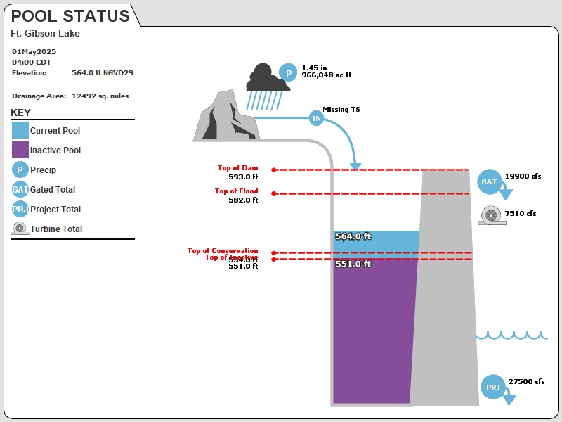
Current Readings:
- 27.83 ft ABOVE normal
- Pool elevation is 581.83 feet on Saturday 25May19 Time: 1400 hours.
- At this elevation the total amount of water stored in Ft. Gibson Lake is 1275882 acre-feet.
- Reservoir release is 227608 cubic feet per second on Saturday 25May19 Time: 1400 hours.
- Flood control pool is 99.07% full.
- Flood control pool storage filled is 910682 acre-feet which is equivalent to 1.37 inches of runoff over the entire drainage basin.
- Flood control pool storage empty is 8517 acre-feet which is equivalent to 0.01 inches of runoff over the entire drainage basin.
Current Gate Settings:
- Tainter Gate 1 = 6.00 ft
- Tainter Gate 10 = 6.00 ft
- Tainter Gate 11 = 6.00 ft
- Tainter Gate 12 = 6.00 ft
- Tainter Gate 13 = 6.00 ft
- Tainter Gate 14 = 6.00 ft
- Tainter Gate 15 = 6.00 ft
- Tainter Gate 16 = 6.50 ft
- Tainter Gate 17 = 6.00 ft
- Tainter Gate 18 = 6.00 ft
- Tainter Gate 19 = 6.00 ft
- Tainter Gate 2 = 6.50 ft
- Tainter Gate 20 = 6.50 ft
- Tainter Gate 21 = 6.50 ft
- Tainter Gate 22 = 6.50 ft
- Tainter Gate 23 = 6.50 ft
- Tainter Gate 24 = 6.50 ft
- Tainter Gate 25 = 6.50 ft
- Tainter Gate 26 = 6.50 ft
- Tainter Gate 27 = 6.50 ft
- Tainter Gate 28 = 6.50 ft
- Tainter Gate 29 = 6.50 ft
- Tainter Gate 3 = 6.50 ft
- Tainter Gate 30 = 6.50 ft
- Tainter Gate 4 = 6.50 ft
- Tainter Gate 5 = 6.50 ft
- Tainter Gate 6 = 6.50 ft
- Tainter Gate 7 = 6.50 ft
- Tainter Gate 8 = 6.50 ft
- Tainter Gate 9 = 6.50 ft
Evaporation Data:
Daily Computed- 0.325 inches - 25MAY2019 @ 0700
Reservoir Data:
| Elevation | Incremental Storage | Cumulative Storage | |||
|---|---|---|---|---|---|
| (feet) | (inches) | (acre-feet) | (inches) | (acre-feet) | |
| Surcharge Pool: | ---- | ---- | ---- | ---- | ---- |
| Flood Control Pool: | 582.00 | 1.38 | 919199 | 1.93 | 1284399 |
| Conservation Pool: | 554.00 | 0.08 | 53899 | 0.55 | 365199 |
| Inactive Pool: | 551.00 | 0.47 | 311300 | 0.47 | 311300 |
Streambed Elevation: 483.00 feet.
Top of Dam Elevation: 593.00 feet.
All storages based on a contributing drainage area of 12491 square miles or 666239 acre-feet
Longitude: -95° 13' 43" Latitude: 35° 52' 16"
Map of Ft. Gibson Lake Dam
Links for More Information:
Graphs of Measured and Calculated Lake Parameters:
View 24H and 1Day Graphs (Enlarged)
Fort Gibson Lake near Fort Gibson, OK
Go to Tulsa District Water Control Home Page.
Disclaimer: The Lake Pages are subject to change.Last Page Update: Saturday, 25 May 2019 15:02
 |
| NewsOn6, Aerial Data Service |
 |
| From a video near the bottom of the NewsOn6 report @ 0:15. [I didn't watch much of the video because I didn't like the player. It is one thing to have your joists and dry wall soaked in water for days. It is something else to have it soaked for weeks.] |
No comments:
Post a Comment