Sahara/O'Gara #1 was just a little northeast of here.
 |
| Jerry Evans posted Old mine O'Gara number 12 Muddy Illinois Jerry Evans This is still standing...I think the only one of its kind anywhere.. Mine closed in 1937 due to the 1937 flood. |
Raymond Barr posted three photos on May 4, 2023, with the comment: "Happy 100th Birthday to this concrete colossus standing tall in Saline County. The sign on the gate pretty will spells out the brief history of the mine that lies underneath this tipple. This site is in the village of Muddy, near the city of Harrisburg. If anything, this concrete structure stands as a shrine commemorating the once booming coal industry and the miners of Saline County."
Mary Furlow: My grandfather Mike Porro was working there when the flood happen, my mother told us the story many times about there house being under water an finally going back an everything ruined from being under water, my mother was born in1929
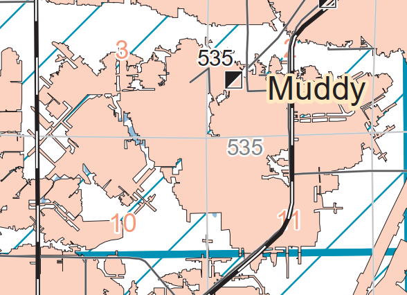
I'm saving the satellite image because the next image may not have the informative shadow. For example, Bing's shadow doesn't show any of the holes. The 3D feature doesn't work on either site for this location.
Google's signature photo for this town is of this structure. Google also has a closeup of the tower.
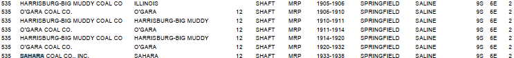
"O'Gara Coal Mine No. 12 (1906-1910, 1911-1914, 1920-1932 ) became Sahara Coal Mine No. 12 in 1933." [hinton-gen] But I could not find any information on Sahara #12.
I did find a reference to a mine in nearby Harrisburg that operated until 1993 even though the Egyptian Line was abandoned in the 1980s. And I see from a satellite image that the American Coal Co is still operating. I noticed there is a conveyor to a feeder mine that is quite long. You can tell from the shadow that the conveyor goes up and over roads. Zooming out and looking at the scale, that conveyor is about a couple of miles long. The mine is served by a loop track off of a nearby CN/IC branch that runs between the Edgewood Cutoff and Eldorado.
It was O'Gara #12
Joe Garret posted four photos of the tipple.
Update:
 |
| 1 |
 |
| 2 |
 |
| 3 |
 |
| Satellite |
Google's signature photo for this town is of this structure. Google also has a closeup of the tower.
"O'Gara Coal Mine No. 12 (1906-1910, 1911-1914, 1920-1932 ) became Sahara Coal Mine No. 12 in 1933." [hinton-gen] But I could not find any information on Sahara #12.
I did find a reference to a mine in nearby Harrisburg that operated until 1993 even though the Egyptian Line was abandoned in the 1980s. And I see from a satellite image that the American Coal Co is still operating. I noticed there is a conveyor to a feeder mine that is quite long. You can tell from the shadow that the conveyor goes up and over roads. Zooming out and looking at the scale, that conveyor is about a couple of miles long. The mine is served by a loop track off of a nearby CN/IC branch that runs between the Edgewood Cutoff and Eldorado.
It was O'Gara #12
 |
| One of six photos posted by M Margaret Reynolds |
Update:
 |
| Directory |
 |
| Springfield Map |
 |
| David Cantrell commented on a post The mine was served by both the NYC and the Southern Illinois Railway & Power Company. Some more information on the Muddy area including aerial photos of 1937 flood here: https://www.mayberrytownship.net/sirp/5.76.html |
Robert Armstrong posted thee photos with the comment: "If you get around Muddy Illinois stop and check out a piece of mining history."
 |
| 1 |
 |
| 2 |
 |
| 3 |
Update: see mines #3 and #4 for the Big Four railyard that used to be between Muddy and Harrisburg, IL.
Sahara No. 12 operated from 1933-1938 in Muddy. Harrisburg Quadrangle map available at: http://isgs.illinois.edu/sites/isgs/files/maps/coal-maps/topo-mines/harrisburg.pdf.
ReplyDeleteAmerican Coal Company shutdown the New Future Mine at Galatia in April, 2017. As an aside, they own right-of-way for the former L&N McLeansboro to Shawneetown Branch from McLeansboro to Broughton. The New Future Mine has made it to Walpole west of Broughton. There was difficulty getting the coal back to Galatia via conveyer. Perhaps it will reopen and the railroad refurbished and connected to the Evansville Western Line at McLeansboro.