NorthAmericanInterlockings: photo
The Big Four was abandoned on the west side, except for a remaining industrial spur connected to BNSF, by the Big Four itself. The east side was abandoned by Penn Central.
 |
Jacob Hortenstine posted
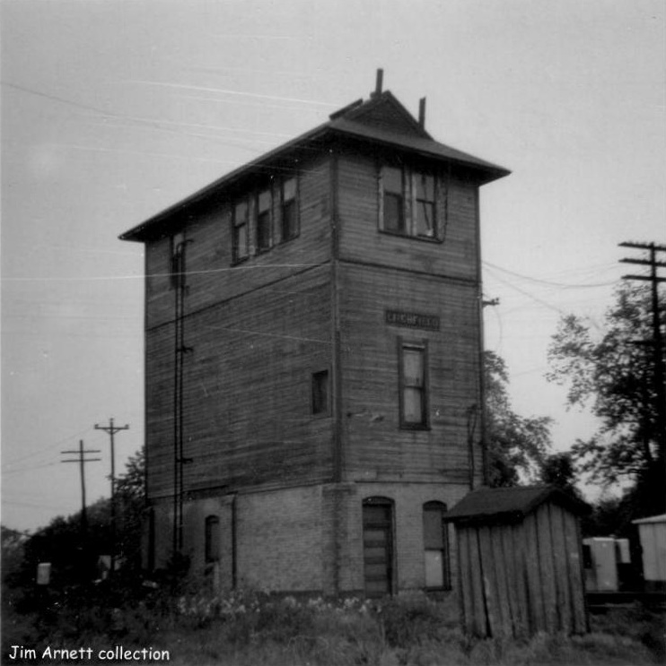
looking north NYC Litchfield Illinois crossing is with Wabash NYC tower
Charlie DeWeese I think this is the job I always wanted to work for the NYC; Litchfield Tower, Open continuously per timetable No 8 October 30, 1960. That timetable showed that Litchfield had a crossing with the IC, Wabash, and CB&Q..
Bill Edrington also postedWhile we're on the topic of unusual NYC power on the Big Four, here is a photo of Fairbanks-Morse H-16-44 unit #7012 working the Old Line local in my hometown of Litchfield, IL in the early 60s, thanks to Jacob Hortenstine. I remember seeing the FM units on the local when I was a kid. This view looks east from the tower which stood at the crossing of the Big Four's Old Line and the Wabash's Decatur-St. Louis 13th District main line. The Litchfield Tower interlocking plant controlled not only the Big Four's crossing with the Wabash, but also the Illinois Central's Springfield District (a block east) and the CB&Q's line between Concord and Paducah (a block west). There were interchange tracks with all three roads, and the Nickel Plate boxcar in the photo is sitting on the connection to the IC. It would have been either a load of empty tin cans for the Litchfield Creamery Company (which was switched by the Big Four) or an outbound empty that had just been placed for the IC to pick up. The Big Four freight house can be seen in the distance, to the right of the main track and siding. The passenger depot which sat on the north side of the main was long gone by this time. The interlocking was automated at about this time and the tower was torn down...but the adjacent outhouse remained standing for some time afterwards. I believe this is a "Cook" Clayton photo. He lived in Litchfield and photographed many railroad scenes in the area back in those days. |
The 2005 SPV Map shows that the IC ran north/south through town between the CB&Q and the Wabash. But a comment by Bill Edrington states "The Big Four crossed Litchfield from east to west, between Edwards and St. John Streets, while the IC ran north-south along Adams Street; the Wabash north-south along Washington Street (only for a short stretch by the depot); and the CB&Q north-south along Clinton Street. The Big Four crossed all three at grade, and had interchange tracks with all three." I'm believe Bill instead of the SPV Map because Wabash in the middle agrees with Jacob's comment and the aerial photo. But that means somewhere north of Litchfield, the Wabash and IC routes need to cross, and I could not find that crossing.
I do think Jacob's comment is wrong because I think we are looking east along the Big Four tracks. That is consistent with the aerial photo showing the long axis of the tower is east/west along the Big Four tracks.
 |
| 1938 Aerial Photo from ILHAP |
No comments:
Post a Comment