Thursday, September 30, 2021

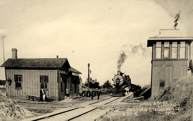
Steubenville, IN: Depot and Tower for Wabash and NYC

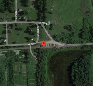
(Satellite, the tower is gone and the depot has been moved)

John Storer posted
Larry Jack: Depot building is on south side of pleasant lake. [I spent some time looking for it on a satellite image, but I could not find it.]
Craig Jon Berndt: The depot is in very poor condition. Five years ago the owner tried to find someone to relocate and preserve it, but there were no takers. Twenty+ years ago I stopped to photograph it and the owner, now deceased, told me that he and his brother-in-law moved it there from Steubenville on two wagons. He asked if I wanted the depot sign, and of course I did. We looked for it in the garage and it wasn't there. We finally found it, in pieces. Grandkids had cut it up for a skateboard ramp.

Terry Wisel Heintz updated
Michelle Smith Sheffield: The depot is at my cousin’s farm. He would love to find a new home for it!
Tom Cochran: Michelle Smith Sheffield he needs to talk to the Fort Wayne Railroad Historical Society.
Eric Davis: Where was this located?

Dennis DeBruler responded to Eric's question
I dropped a pin on the crossing we see in the left side of the photo.
https://www.google.com/.../data=!3m2!1e3!4b1!4m4!3m3!8m2...

That was a simple junction, I see only a couple of signaling pipelines leaving the tower.

It appears the buildings were on the south side of the track. The NYC was the north/south route and the Wabash ran east/west.
1942 Ashley Quadrangle @ 1:24,000

When I saw the spur going south from the Wabash on the east side of the NYC, I checked out the satellite image. I wonder what was mined because the lake has grown since 1942. Were they digging marl for cement like they did at the end of a Wabash spur in Stroh?
Satellite

Originally, the NYC route was the Fort Wayne, Jackson & Saginaw and then the Lake Shore & Southern Michigan and then it was absorbed by NYC.
Terry Wisel Heintz posted
Steubenville Indiana.
Tim Shanahan shared
The resolution of a 1958 aerial photo is poor, but it appears the buildings are north of the Wabash tracks. So this train is southbound.

A different exposure of this photo.
Bill Molony posted
Steubenville, Indiana was where the New York Central Railroad's branch between Jackson, Michigan and Fort Wayne, Indiana crossed the Wabash Railroad's main line between Chicago and Detroit.
Back in the 1920's the NYC had two steam passenger locals and a motor car run each way daily that stopped here.
The Wabash had one daytime and one night express each way between Chicago and Detroit each way daily that were not scheduled to stop here.

Terry Wisel Heintz posted
Steubenville.
Dennis DeBruler: Where the Wabash crossed the NYC.


Wednesday, September 29, 2021

West Duluth, MN: C Reiss Coal and Superior Fuel Rail Terminal

Reiss Coal: (Satellite)
Superior Fuel: (Satellite)

I remember this dock area from when I studied the steel plant that was a little west of here. The propane transloading is new enough that it doesn't show up yet on the satellite image. I wanted to record that some coal gets shipped from the east to here. Is it anthracite? Generally, Powder River Basin coal gets shipped from this region to the Midwest. The boat in the photo is an old one because it has the pilot house on the bow.

(Update: just the day after I published this, I learned that there is also a C Reiss Coal Dock in Green Bay, WI.)

David Schauer posted
I wanted to get a shot of the new Superior Fuel propane transload and storage facility at the former Hallett 7 (Carnegie) dock in West Duluth. The Hon. James L. Oberstar is in the distance at C. Reiss unloading eastern coal loaded at Toledo and used locally as blending fuel in biomass plants and for periodic test burns in some of the pellet plants. 9/23/2021

These docks are served by BNSF/Northern Pacific.
1954 West Duluth Quadrangle @ 1:24,000

Other materials help keeps the dock in business.
David Schauer posted
Algoma Transport arriving at the C. Reiss dock in West Duluth with a load of salt. The Transport is on the retirement watch list. 11/3/2021
Mike Zins: Isn't any boat loading salt on the watch list?
David Schauer: Mike Zins Yep, except the ones with special coating for salt hauling (e.g., the new Mark Barker).
Isaac Pennock: Transport scheduled to be retired at the end of the 2023 season as announced by Algoma.

The dock company is on the right in this photo.
Street View, taken from the Bong Bridge

The dock is on the left and the bridge is on the right.
Street View

 Rich Hoeg, CC BY-NC-ND 2.0, flickr.com/photos/northstarnerd/ via Historic Bridges
"This railroad bridge is noted for its very large swing span." [430']
[Again, the dock is in the background.]

The dock company also handles bulk materials other than coal.
Street View
[We can clearly see the piles built by the self-unloaders on the ships.]

This historical photo of the Zenith Furnace Co. shows that the C Reiss Coal Dock was probably built on landfill.
1905?. "Zenith Furnace Company, Duluth, Minnesota." University of Minnesota Duluth, Kathryn A. Martin Library, Northeast Minnesota Historical Collections, Accessed January 3, 2021. https://reflections.mndigital.org/catalog/nemhc:4576 via DeBruler, cropped

The 1954 topo above shows that the landfill was built by then.

Sammy Maida posted
This photo isn't mine, file photo from Basgen in 59 of Zenith Furnace/Interlake Iron at Duluth, present day Reiss Coal docks.
 
David Schauer posted
Arthur M. Anderson arriving Duluth with limestone for C. Reiss. 10/4/2021

David Schauer posted
Today the weather-delayed Clarke and Anderson both arrived Duluth with limestone. I elected to stick with the Clarke as it was going upriver to C. Reiss whereas the Anderson was going to CN-Hallett Dock 5 and I could get her later. This might be the last winter for large commercial ships to C. Reiss' West Duluth facility depending on how quick they get their Superior terminal up and running. The funky snow patterns on fresh ice also made for some really neat images (almost makes me dizzy looking at that pattern). The open water and track in the ice near the stern was from a small USCG buoy tender swapping out summer to winter aids to navigation. 11/22/2022
Eric Allen: Sorry to hear of the Duluth slip closing. Maybe someone else can purchase it?
David Schauer: Eric Allen The land might be usable for other storage options. The Superior site next to MERC has a deeper draft channel.
 
David Schauer posted
A sucker hole of sunlight illuminated the bow of the Clarke as it made the turn into C. Reiss in western Duluth last week. If you look close you can see sister Anderson headed to CN-Hallett Dock 5 in the distance. 11/22/2022
[This Nov 22 ice looks thicker than the Dec 4 ice in the following photo.]

David Schauer posted
Heritage Marine tug Helen H softens ice as the Anderson departs C. Reiss in West Duluth on Sunday just after sunrise. 12/4/2022
David Szymanski: Is C. Reiss the only customer that uses shipping traffic on that of the bridge?
David Schauer: Yes.
Duane Haigh: Do They still use that railroad line ?
David Schauer: Duane Haigh Yes, main route between Duluth and Superior operated by BNSF and also used by CP and UP.

Schauer Photo Images posted 
A double rainbow over the Arthur M. Anderson unloading limestone at C. Reiss in West Duluth this evening. June 12, 2024

The primary rainbow in the middle is so brilliant that I almost missed the secondary rainbow on the right side.
David Schauer posted
Here is a closer view of the rainbows over C. Reiss in West Duluth yesterday evening after thunderstorms rolled through. Arthur M. Anderson unloading limestone before departing empty for Two Harbors. June 12, 2024

David Schauer posted
After some heavy weather moved through the Twin Ports, a beautiful rainbow appeared over the Arthur M. Anderson  unloading limestone at C. Reiss in West Duluth. June 12, 2024


Tuesday, September 28, 2021

Chebanse, IL: IC Depot and Grain Elevator

(Satellite)

Chris Goepel posted
The wood frame IC depot on the Chicago District at Chebanse, Illinois, during winter. Postcard view is from circa 1910.
Brian Patterson: The Depot Building still stands and is in use as the Chebanse Village Hall. The line is now single track.
Paul Jevert shared
Dirk Hafner: Was that a coal chute in the background?
Dennis DeBruler: Dirk Hafner A wood grain elevator. It is not unusual to see two buildings in an old photo of a small town: a depot and a grain elevator. A bigger town would have more than one grain elevator.
Dennis DeBruler shared
The depot still stands, but the wood grain elevator has been replaced by a more modern grain elevator.
41°00'03.6"N 87°54'33.6"W

Andy Zukowski posted
Photograph of the Illinois Central Railroad Depot in Chebanse, Illinois taken in 1908 by C. R. Childs
 
Andy Zukowski posted
Illinois Central Railroad Depot in Chebanse, Illinois. 1908

An intermediate generation of the grain elevator.
Jim Arvites posted
View of a southbound Illinois Central freight train passing the IC depot at Chebanse, Illinois on October 10, 1988.
(Mike Abalos Photo)
Kevin Keller commented on Jim's post
View from June 2018 via google. [Street View]
 
Illinois Central Railroad Scrapbook posted
Illinois Central 4-8-2 2605 hustles southbound through Chebanse, IL, with a long train of empty coal hoppers, headed back to the mines to be reloaded with "Black Diamonds".  The photographer wrote the location and date (Sept. 18, 1954) on this original "red border" Kodachrome slide, but alas not their name!  Photo from Cliff Downey coll.
Cliff Downey shared
Cliff Downey shared

Obviously, the elevator rebuilt north of town where they could get more land.
Satellite

Andy Zukowski posted
Illinois Central & Gulf Railroad Depot in Chebanse, Illinois. 1981
Richard Fiedler shared

Street View

Street View

Fertilizer is a big business for some grain elevators.
Street View

I couldn't resist including the corn crib.
Street View

In the satellite image, there appears to be a locomotive parked on the siding. But I don't see a fall protector. So it must not be rail served. Is the locomotive owned by CN? They do have a small yard north of here. It continues to amaze me that there are still glass insulators on the cross arms of the code line. Are IC insulators so ubiquitous that they aren't worth anything to collectors?
Street View

Monday, September 27, 2021

Cleveland, OH: W&LE/NKP/W&LE Freight House, Roundhouse, Railyard and Depot

Freight House: (Satellite, building is gone, address came from case.)
Railyard: (Satellite)
Roundhouse: (Satellite)

W&LE = Wheeling & Lake Erie

1953 is my typical year for topo maps in urban areas. But by 1953, NKP had already absorbed the W&LE. Since NKP's mainline also went through Cleveland, I used an older map to verify the W&LE routes. The freight house is marked by the red cross in the lower-right corner of this topo extract. The railyard is the one to the right of the "RIVERSIDE CEMETERY" label on the left side of the extract.
1903 Cleveland Quadrangle @ 1:62,500

While studying the railroad bridge next to the Carter Road Bridge in Cleveland, I found the following label on Google Maps.
Satellite

I soon determined that the label must be a mistake. It was the Erie railroad that was in the vicinity of this building, not the W&LE. So when I came across the correct address of the W&LE freight house (3959 E 93rd St. [case]), I wrote these notes to capture that information.
 
Lynn Thomas Dostal commented on a post
Who remembers the NKP roundhouse and dorm on Campbell Road?

The caption on this photo caught my attention. Was this 93rd Street Station the main station for Cleveland or just a suburban stop? It is a rather old looking locomotive for a last passenger train.
Michael Schwartz Library, Cleveland State University via collection
Last passenger train at East 93rd Street Station

The Central Viaduct went where I-90 now crosses the valley. [case, ClevelandHistorical, PressBooks] But I can't find a route of the W&LE that went far enough north to go under the Central Viaduct.
Michael Schwartz Library, Cleveland State University via collection
Mainline in Cleveland, looking south under the Central Viaduct. Freight House visible on right.


Sunday, September 26, 2021

Atlantic, IA: IAIS/Rock Island Depot

(Satellite)

Raymond Storey posted

Dennis DeBruler commented on Raymond's post
That depot is still standing.
41°24'36.8"N 95°00'46.5"W

Unfortunately, the street view driver did not go down this side street. Nor the side street that crosses the tracks.
Street View


Saturday, September 25, 2021

Jersey City, NJ: Pennsy Greenville Yard and the Tridents for the World Trade Center

(Satellite)

See Railroad Terminals for an overview of the ferry terminals in Jersey City, NJ.

Go here for the WTC Tridents.

Some of the ferries went between here and the Oak Point Yard of the New York, New Haven & Hartford Railroad.

Jack Bobby Lou Mulreavy posted
Spectacular aerial photo of Greenville Yard, Jersey City NJ
James Musser: They still float rail cars from this yard. Also, on the far right of this peninsula was the Lehigh Valley facility - separated from the PRR yards by a small, semi-visible water slip. The Lehigh Valley had two Hullet Unloaders in this yard to unload foreign iron ore and ship to Bethlehem Steel. Hullets were fairly common in the Great Lakes/Mid West Steel industry, but these two, and one to unload trash somewhere in NYC were the only ones on the East Coast.
Paul O'Brien: James Musser The Claremont Terminal
Jack Bobby Lou Mulreavy: The cumulative value of the real estate owned by railroads along the Hudson River waterfront in today's dollars is in the BILLIONS.
Tad Dunville: Jack Bobby Lou Mulreavy by 1992 the EL had paid off their bond holders by selling any former EL property that didn’t have a blue train currently operating over it.

Charlie Smith posted
PRR car floats #648 and 562 temporarily sit empty at float bridges No.8 & 9 at the Jersey City waterfront. Photo courtesy of the Jersey Room of the Jersey City Main Library.
Bennie Briscoe shared
Paul O'Brien: Stockyards in the background.

Dennis DeBruler commented on Jack's post
Unfortunately, this is a test to see if Facebook will delete this comment because I have the audacity to include a URL that documents the source of the image.
.

World Trade Center Tridents


Marshall Smith posted
Steel for the WTC at a New Jersey rail yard 1969.
And for scale, each one of those tridents is 70 feet tall and weighs 50 tons.
James Torgeson shared
Multiple carloads of the signature World Trade Center tridents are shown in the Penn Central Greenville Yard in Jersey City, NJ. These were fabricated by Pittsburgh-Des Moines Steel (PDM) at their plant on Neville Island near Pittsburgh. PDM used very heavy plate made by Lukens Steel in Coatesville, PA. The 50-ton tridents will be carfloated across the Hudson River to a Manhattan pier near the jobsite on a just in time basis.
Dennis DeBruler shared
Some comments that indicate these World Trade Center tridents were stored in Pennsy's Greenville Yard.
Stanley Kenny Luzarski: Wow I worked there in 1969 I was 18 years old Greenville piers located in the Pennsylvania Rail yard my dad and my uncle Steve and my brother in law Tony also worked there my uncle Steve was one of the crane operators if you look in the picture you see the Derek's on the tracks the were powerful enough to lift almost anything they ran on steam I was a rigger the steel would come in from Chicago America Bridge steel via rail we would store it here until the they want order numbers then flat bed trailer trucks we load the trucks then they would drive thru the the tunnel to New York also the big pieces we would put on barges that section you seen the photo we called it Siberia we were Longshore men we worked for Jersey Contracting Corporation.


Emil Luk commented on Marshall's post
Colorized and sharpened
 
Cide Farign posted
the iconic trident being positioned
Jason Murawski: The beams were more than adequate for the towers. They were engineered to stay stable even with 1/3 of all vertical columns being destroyed.
James Torgeson shared
One of the famous World Trade Center Tridents being hoisted into place. They were fabricated by Pittsburgh-Des Moines Steel (PDM) from heavy plate made by Lukens Steel.
Jennifer Sarb: The plates were actually flame cut into the fork shape at Lukens before they were shipped out.
I used to work there and one day we went hunting and found the original engineering drawings for them filed away with all the other flame cut drawings. I'm pretty sure they were given to the National Iron & Steel Museum soon after.
Casey Weston: That guy on the float ,at the connection ,will be welding on that for a week-solid...
Phil Jadlowiec: PDM   PITTSBURGH Des-Moines Steel
James Torgeson: Phil Jadlowiec On Neville Island in Pittsburgh!
Dennis DeBruler: Phil Jadlowiec Was that steel plant also known as Shenango Steel Works? Or did Neville Island island have two different steel plants?
Dan Thomas: PDM was either bought or merged with Chicago Bridge and Iron or CB&I today.
Phil Jadlowiec: Dennis DeBruler Shenango was at one end, coke plant began shut down in 2016, they were located at 200 Neville Road. PDM was located at 3400 Grand Ave, I think the addresses are correct.

Jonathan D. Egger commented on Cide's post
[This is somewhere in downtown Coatesville, PA.]
 
Joseph GC posted
Twin Towers under construction
📷 New York Storie e Segreti
James Torgeson shared
The famed WTC Tridents that were fabricated by Pittsburgh-Des Moines Steel are shown clearly in this view. PDM started with super heavy plate that was made by Lukens Steel in Coatesville, PA.
 
Social Park USA posted
1968. This photo, taken during the early construction phase gives a great look at the below ground levels of the North Tower, parts of the building you'd never normally be able to see.
Annotated is the concourse level, which was both street level as well as the same level on which most of the World Trade Center's indoor shopping mall was located, and the plaza level, which was home to the upper section of the towers' lobbies and was the level on which the expansive, 5 acre outdoor plaza was situated.
The World Trade Center housed 6 basement levels, which held everything from a PATH rail station, subway connections and parking facilities to a myriad of technical and mechanical equipment which kept this city in the sky functioning.

Focal Points posted
The World Trade Center under construction. (1970)
 
DogsDear posted
In 1970, the World Trade Center towers were still under construction, rising high above the New York City skyline. Designed by architect Minoru Yamasaki, the Twin Towers were an ambitious project, meant to symbolize international trade and economic power. By 1970, the North Tower had reached its full height, and the South Tower was well on its way. The construction site was a massive undertaking, involving thousands of workers and cutting-edge engineering techniques for the time.
The towers, once completed, would become the tallest buildings in the world and an iconic part of New York City’s landscape. Their innovative design included a "tube frame" structure, allowing for the open floor spaces that became a hallmark of the buildings. The World Trade Center complex was not just a feat of engineering but also a symbol of hope, progress, and global unity.
Mike Shrum: Looks like a fake photo. Where are the rest of the tall buildings?
History Collection posted
The World Trade Center under construction in 1970. Designed by Minoru Yamasaki, work on the foundations began in 1966. However, contractors didn't start building the actual towers until 1968. They were opened to the public in 1973.

BillyBoy Krueger commented on the above post

Uncovering PA posted
This giant piece of steel sitting outside of the National Iron and Steel Heritage Museum in Coatesville, PA once held up the first floor of the World Trade Center. This piece returned to this historic steel mill after being made here [Lukens Steel in Coatesville, PA] in the 1960s. Remarkably, many of these steel trees remained standing amidst the rubble.
 
History pictures posted
[The description sounds like AI generated platitudes.]

These notes have evolved into also being World Trade Center construction notes.
The History Insider posted
A Monument to Modernity: The World Trade Center Under Construction
 In the bustling heart of Lower Manhattan, a colossal undertaking was underway in 1967. The twin towers of the World Trade Center, designed by the renowned architect Minoru Yamasaki, were slowly but surely reaching toward the heavens. This ambitious project, once completed in 1973, would redefine the skyline of New York City and claim the title of the tallest buildings in the world.
[The rest of the description is platitudes.]

History pictures posted
[The description sounds like AI generated platitudes.]

Social Park USA posted
The Twin Towers in Construction in 1971 🇺🇸
 
Cinematic Vibes posted
The construction of the World Trade Center in Lower Manhattan was a groundbreaking endeavor that transformed New York City’s skyline and symbolized the city’s global economic prominence. Spearheaded by the Port Authority and designed by architect Minoru Yamasaki, the twin towers broke new ground in both engineering and design. The towers’ innovative “tube-frame” structural system, which moved the weight to the outer walls, allowed for expansive interior office spaces and pushed the boundaries of skyscraper construction. Completed in 1973, the towers stood as the tallest buildings in the world at 1,360 feet, becoming an iconic part of New York's skyline.
For almost three decades, the World Trade Center was a symbol of America’s technological achievements and economic optimism, housing thousands of businesses and attracting millions of visitors. The observation deck and the famous “Windows on the World” restaurant on the 107th floor became top destinations for tourists and locals alike. However, the towers’ destruction on September 11, 2001, left an indelible mark on the city and the world. The tragic loss was met with an outpouring of resilience and a commitment to remembrance, embodied in the One World Trade Center and the 9/11 Memorial & Museum, ensuring that the spirit of the original towers lives on as a symbol of hope, progress, and unity.
 
Cinematic Vibes posted
[The description is different than the one above, but redundant. I'm ignoring comments that 9/11 was faked.]

The History Insider posted
[The description has no new information.]


Back to the Railyard


Charles Crawford posted
Whoops! The one on the left seems to be listing to starboard, or portside, depending on which way is front! lol
Charles Crawford: Now, HOW would they ever get those cars off with the rails not aligned?
Paul Strubeck: The bridge moves..
Charles Crawford: At a 10 degree verticle angle?
Paul Strubeck: Yup

Jack Bobby Lou Mulreavy posted ten photos with the comment: "Little more Greenville stuff-here are some images from the Historic American Engineering Record (HAER) that were taken shortly after the start of Conrail. At the beginning of Conrail, the wires were still up and energized all over the system and Greenville was no exception. Here we see photos of the gantry cranes and pier warehouses that existed at the time. Capacity of the yard was a whopping 7168 cars!"
1

2

3

4

5

6

7

8

9, cropped

10

Comments on Jack's post

Jack Bobby Lou Mulreavy posted 16 images with the comment: "There have been several posts regarding Greenville Yard in the PRR group and so in the interest of "refreshing" our memory of what was there, I present this booklet released by the Pennsy to promote waterfront terminals in NY, Philadelphia and Baltimore. This one shows the extensive facilities around NY harbor including Greenville, Harsimus Cove and more."
1

2

3

4

5

6

7

8

9

10

11

12

13

14

15

16

So I searched the group for "greenfield" and found some more tidbits.

Jack Bobby Lou Mulreavy commented on a post
If you look closely at the bottom left corner of this map you will see "PRR" and the word Greenville. This will give you an idea of Greenville's relationship to Jersey City. The PRR also had Harsimus Cove Yard and the passenger ferry at Exchange Place JC but the were farther north of Greenville.

Jack Bobby Lou Mulreavy commented on a post
Another map showing location of Greenville Yard. At one time G'ville was electrified and trains originated and terminated there from places like the Midwest and Chicago. BIG perishable market served by the SIX carfloats across the bay.

Jack Bobby Lou Mulreavy posted
View of the Greenville barge transfer- the Greenville section is south of downtown Jersey City NJ

Jack Bobby Lou Mulreavy posted two photos with the comment: "PRR carfloat derailment at Greenville with a poor shot of a wreck derrick that served the event. From the JW Barriger collection."
1

2

Seven of the twelve photos posted by Jack Bobby Lou Mulreavy with the comment: "Archival photos from Railway Age showing various float bridges and yards around NY Harbor including NH Oak Point, LIRR Bay Ridge and Hunterspoint, PRR Greenville and Harsimus Cove. Also some rare images of the earlier float bridges at Greenville."


c

d

e

f

g