The ISW still exists but, according to their map, it now operates just 3.8 miles of track in Evansville. I noticed the "v3" (version 3) in the link, so I changed it to v2 and I got another PDF file. Since v1 no longer exists, I made the copy of v2 below which shows the 17 miles they used to operate.
.pdf%2B-%2BAdobe%2BReader.png) |
| http://www.pioneer-railcorp.com/images/ISW%20map%20v2.pdf |
The ISW site still claims that they handle grain, plastics, and rail equipment. But Wikipedia indicates ISW quit handling grain in 2011.
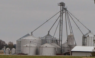
I made a second trip to the feedmill to ask about the impact of the lost of the rail service. He said it wasn't a really big deal because all of their grain is used to make feed for the farmers that store there grain in the elevator. Farmers who want to sell their grain as a cash crop truck it directly to a barge-loading facility in Mt. Vernon, IN. That explains why some of the local farmers have such large storage facilities (see below).
When I was on the north side of Poseyville, I spotted a railroad abandonment that had a North-South orientation. That is when I realized the town had two abandoned railroads.
 |
| Looking "Northish" |
 |
| Looking "Southish" from same location |
When I saw this, I went back into town and explored this route. I determined that the above street crossing is the only one that has had the rails removed. Even the main street through town still has rails. And I wonder if that old wood building used to be the freight house. I found an old grain elevator along the former C&EI tracks. I took a lot of pictures of it because it had so much "character." I figured it was abandoned a long time ago because it did not have room to expand with steel bins and the town had another elevator. But then I noticed that trucks were servicing the elevator. Note that the closest concrete silo is bigger than the other two.
The above view is from the Southwest. The view to the right is a complementary view from the Northeast. I took the view below to document that they tore up the tracks, but they did not bother to remove the No Trespassing signs.
But now I noticed that there is an elevator leg in the background so I digitally zoomed in on the background. Were there three elevators in this town or is it an expansion of this elevator? On the other side of the road from the above No Trespassing sign had cable markers.

My first thought was that someone didn't bother to remove these signs as well. Then it occurred to me that the town may not have microwave or fiber optic access. If they are still connected to the outside world with coax cable, I wonder how slow their internet access is. So the C&EI right-of-way may still be used, just not by a railroad.
I continued to work my way south through town until I found the old interconnect track that became a branch lead when the C&EI was abandoned to the south a lot earlier. Below is a view from the same spot looking North instead of a little South of East. Note that they didn't bother to pick up the ties when they did the first phase of abandonment. And south of where I'm standing the track elevation has been completely removed to make the drainage ditch that you see in the view to the West below-right. The former-IC tracks would have been on the other side of the trees on the left and the "brown line" that is this side of the trees in the middle.
On the right is the farm on the right side of the above picture at camera resolution. I'm going to have to rethink setting the camera to ISO 400 instead of ISO 100 because this picture seems rather "grainy."


No comments:
Post a Comment