(
Satellite)
 |
Glen Lyon, PA posted
The Glen Lyon Coal Breaker
John Selecky: The divider.......this side and the other side!!
Barbara Kielar Kline: Remember it well, too. Big deal, walking to the movies on "the other side of the breaker"
Edward Blockus: I remember the fire of this thing...had burning embers fall out of the sky into my backyard in Sheatown..I remember we had no school for a week @ Pulaski because of it.
Thomas Hill: I remember the night it burned, it was hard to stand 6 blocks away. |
The mine did split the town into two pieces. The Pennsylvania Railroad served this mine.
 |
TheMischpocheTree
Owen Michael Cafferkey II provided the link in a comment in the above Facebook post |
 |
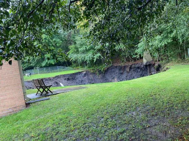
Deborah Zaleski photo via pahomepage
"Chief Kowalski said 14 of the nearby apartments have been condemned causing roughly 20 people to be displaced. There have been no reported injuries.
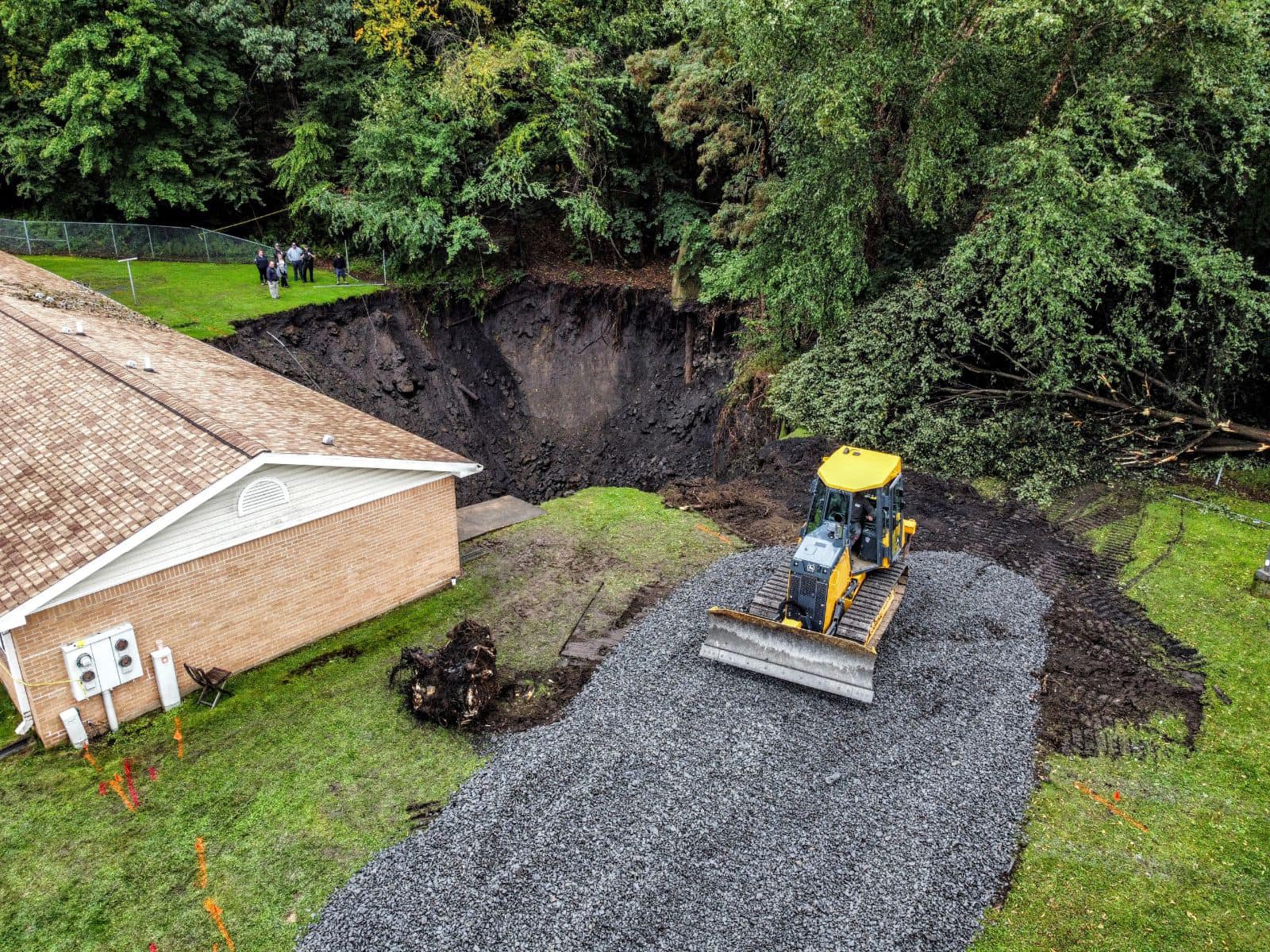
The Department of Environmental Protection says the hole is about 60 to 80 feet [34m] deep. The problem is mine subsidence in an area known for such issues through the years." The 14 apartments are in two buildings. |
There is only one 1-story building in this development, so the hole is near the lower-left corner of this image.
The mine subsidence is 750' (230m) deep. They won't let a resident go back and fetch the $100 of groceries that he just bought. And he has no more money for food. (This is low income housing.) [
phl17]
"This sinkhole's been a persistent problem. Officials say a sinkhole originally opened up in the same exact area back in 1981. Residents say it's a byproduct of the coal region." [
wnep_sep_25_2023]
The concrete column on top of a pipe on the right side of the hole is one of the vent pipes for the mine.
 |
Photo via TimesLeader
"Connelly said that the apartment building does not appear to have shifted, which is a good sign, but heavy rainfall is contributing to the ground being moist and unstable." |
 |
CitzensVoice
[I think that hole is worthy of a bigger excavator. Or do they backup the dump trucks to the edge of the hole?] |
Underground Miners
posted four photos with the comment: "It Appears the Glen Lyon No.6 shaft has subsided open!"
 |
| 1 |
 |
| 2 |
 |
| 3 |
 |
| 4 |
 |
John Corgan commented on Photo 1
Is the location highlighted in yellow the elevator shaft location and the area circled in red the original mine entrance slope ? |
Underground Miners
posted four photos with the comment: "A 1930 photo of the Glen Lyon No 6 shaft that subsided today. You can see the location overlayed on a surface mine map. Also some better photos of the subsidence thanks to a friend. The debris on the roof of the building in the previous post is actually from a 60’ tree that fell, now completely swallowed by the subsidence. It is continuing to grow in diameter and depth."
Peter Stockschlaeder: Reinforces the idea/need that the mine maps should be all digitized and also build the appropriate 3D models. I know there's some projects out there already but hopefully this will get some higher priority now!
Bobby Hughes: Peter, your suggestion is currently being done and has been ongoing for over a decade or more to get any publicly available mine maps and some private collections into the PA Historic Underground Mine Map Inventory System (PHUMMIS). Our non-profit has been working with the State for a long time to scan, catalog, digitize, georeference, and mosaic the mine maps from Wilkes-Barre PA DEP BAMR Office, and the Pottsville District Mining Office, and Deep Mine Safety collection, in addition to Earth Conservancy's Maps and Girard Estates. Over the years, several other universities have been working on this type of work as well. The mine maps you can review today on the Mine Map Atlas that is served up on Penn-State's server has tens of thousands of maps, both surface and underground that EPCAMR has completed and then are approved before being uploaded to the Atlas. The 3D modeling will come. We have some examples of some 3D modeling we've completed years ago using Earthvision, GlobalMapper, and more recently ArcGIS Pro on our webpage.
www.minemaps.PSU.edu David John Briggs: In the UK we cap the shafts like this at rock head. Imagine a champagne cork. The concrete plug below this cap goes down many yards. The shafts back filled with clean limestone from pit bottom upwards and when the filling gets to any water aquifer, the shaft men will have removed the brick shaft lining and that area will be filled with clay to many yards thickness, thus sealing the aquifer from the mine water in the shaft over time. The limestone infill continued to the surface. A vent placed in the cap to vent any methane collecting under the cap ,as over time the limestone in the shaft will settle ,thus leaving a void under the cap.
This type of cap is built to last a minimum of 400 years….. after that 🧐🧐🧐🧐🧐
 |
| 1 |
 |
| 2 |
 |
| 3 |
 |
| 4 |
 |
Sue McCormack commented on the above post
Year not known |


What is the source document for the image of the map labeled "3" that shows the tracks of the old colliery near the no. 6 shaft?
ReplyDeleteWould be very interested in looking at the full map
You need a login to Facebook so that you can contact "Underground Miners." That is the author of the post that provided that image: https://www.facebook.com/undergroundminers/posts/pfbid02wjRBuoE11nN2igMTW46N31KWB2u9MwiWCQy3dsUQv6KrpYzgY5f22s7m7TTSUhmAl
Delete