 |
| Charles Geletzke Jr. posted NYC-PC-CR Beaubien St. tower in Detroit, Michigan on October 5, 1974. This is where the GTW's Mt. Clemens Subdivision crossed the NYC's Bay City Branch. It was also where a little line of the Wabash diverged from the GTW. GTW trackage here was additionally used by the D&TSL and DT&I. (C.H. Geletzke, Jr. photo) |
It is a good thing I looked closer, because at first I thought this was a duplicate posted in a different group.
 |
| Charles Geletzke Jr. posted Former NYC-PC-CR Beaubien St. interlocking tower in Detroit, Michigan on February 4, 1980. Also handled trains of the GTW-D&TSL-Wabash (N&W)-DT&I. (Jack G. Tyson photo) Charles also posted |
 |
| Robert Thatcher commented on Charles' post Here is the interior of Beaubien Street tower, in early 1976. Somebody more knowledgeable than I can explain the color coding for the levers and other items seen in the photo. |
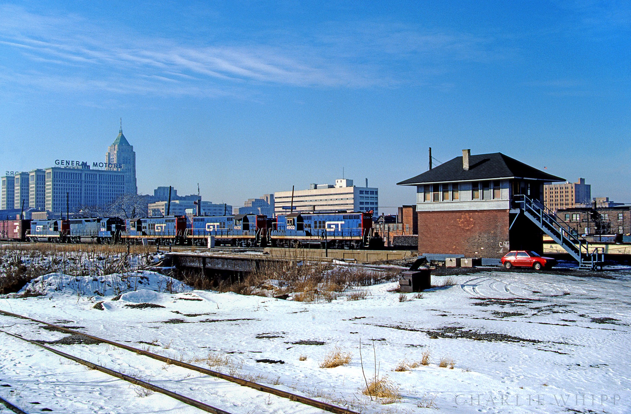 |
| Charlie Whipp posted Today's Flickr photo for Grand Trunkers' .....I caught GTW 4902 approaching Beaubien interlocking tower on the north side of Detroit on a nice winter day but remember being a little ticked about the leased unit fourth up in the otherwise all GP9 consist. In the background the office towers of the General Motors Building (1922) and the art deco designed 30 story tower of the landmark (1928) Fisher Building. Both of these beautiful buildings were designed by famed industrial architect Albert Kahn. They're both personal favorites of mine. At one time Wabash, Lake Shore and Michigan Southern, Grand Trunk and Michigan Central (double tracked Bay City branch) all passed through here on this elevated trackage constructed during the early 1900s. Beaubien closed in early 1996 and was automated with the tower itself razed shortly after it was closed. Taken 1/11/1986 Link to a photo tour of the beautiful Fisher Building in comments. Charlie Whipp: https://www.fisherbuilding.city/ Peter Dudley shared Beaubien Street Tower (1916-1996): Tim Shanahan shared |
 |
| Mike Puroll commented on Peter's share I worked here a long time ago. I always took my watchdog. Fred Ottusch: And kept the door locked ! |
 |
| Charles Geletzke Jr. posted Today you would say that our train was headed southbound; but on January 6, 1991, before the hands of the IC assumed command, our GTW train was headed west. Here we are approaching the tower at Beaubien St. (aka "Sleepy Hollow") in Detroit, Michigan. You can see the former MC-NYC-PC-CR tower in the distance. (C. H. Geletzke, Jr. photo) Charles Geletzke Jr. shared |
 |
| Comments on Charles' share |
 |
| Photo |
 |
| Beaubien Street Junction Satellite |
 |
| Satellite |
I assume that when the Milwaukee Junction Tower was an "armstrong tower" these these two "satellite" junctions had their own switchtender shacks. When Milwaukee Junction Tower was upgraded to pneumantic or electric control, then the tower probably also controlled these remote junctions. Of course, now the spurs and their corresponding junctions are gone and the Milwaukee Junction is controlled remotely by a dispatcher.
Once again, we now have useless bridges because the Interstate system had to build over or under the railroads that they would help kill. At least someone is getting some use out of these bridges.
Update: Charlie Whipp Flickr 1985 Photo (source) is facing Southwest and we see the Beaubien Street Tower on the left. You can see the now abandoned tracks behind the tower. The building with the GM sign is now the Cadillac Place because GM moved its headquarters downtown. The tower on the right in the photo is the Fisher Building.
 |
| Peter Dudley posted The Michigan Central / New York Central / Penn Central / Conrail Beaubien Street Tower, as photographed by member Charlie Whipp in January, 1986. The tower opened in 1916, closed in 1996, and was demolished shortly after closure. This location is unusual, in that it features four (previously six) "movable point diamonds", which are necessary due to the severe angle of the level crossing. Normal open diamond points at this junction would lead to derailments. This photo, taken in a northerly direction along the eastern edge of Brush Street, shows the 1911 former - Michigan Central Peninsular Spur overpass, before the rails were removed (foreground), and the previously-vacated 1911 Lake Shore & Michigan Southern Railway / New York Central overpass (visible just south of the tower). Beaubien Tower housed a 36-lever Saxby & Farmer interlocking machine. As of the tower's closing (February 28, 1996), nineteen levers were still active. In 1935, Beaubien Street Tower controlled: the crossing and connection of the former-Michigan Central (MC RR) double-track Bay City Branch, with the former-Lake Shore single-track New York Central mainline; the crossing of the Bay City Branch, and Grand Trunk Western's double-track Mt. Clemens Subdivision; the connection (east of the tower and Beaubien Street) between the west end of the Wabash-owned Russell Street Branch, diverging from the Mt. Clemens Subdivision; the connection (near Woodward Avenue Station) between the west end of MC RR's Peninsular Spur, diverging from the Bay City Branch [Michigan Central Railroad Detroit Terminal Timetable No. 76]. [Information and photo retrieved from RRHX (www.MichiganRailroads.com)] Tim Shanahan shared |
Darren Reynolds posted two images with the comment:
Conrails ( EX-NYC/MC)"Beaubien St." towerDetroit, MichiganThis tower is no longer standing
Roman Sudney: NYC/MC Detroit to Mackinaw branch.
Tim Shanahan shared
 |
| 1 |
 |
| 2 |
No comments:
Post a Comment