Thursday, October 31, 2024

New Haven, CT: 1929-1991 200mw "English Station" Power Plant

(Satellite)

Street View, Aug 2024

Several sources indicate that one reason why the building is still standing is asbestos. They also say that PCBs needs to be cleaned up. PCBs surprised me. NewHavenIndependent explains that they used PCB-laden oil to hose down the coal to keep it from being dusty.

English Station produced 200mw in the 1950s. [YaleDailyNews, I skimmed this source because I do not like reading about illegal "urban exploration."]

Bob Lincoln posted
“English Station” power plant on Grand Ave. in New Haven, Ct.

Originally, it had four brick chimneys.
nhba

nhba

NewEnglandRuins, this webpage has a lot more interior photos

When built, it burned coal. Later, it switched to burning oil. Back when it burned coal, I wonder how it got it. NYNH&H that went down along the river, but it was on the other side of the river from the power plant. The railyard near the upper-right corner was the Cedar Hill Yard.
1954/59 New Haven Quad @ 24,000


Du Quoin, IL: IC Depot

(Satellite)
 
Illinois Central Railroad Scrapbook posted
IC 4-8-2 2604 rolls past the depot at DuQuoin, IL,with a long string of hoppers. The date is October 18, 1958, and the end of the steam era on the IC is drawing near. The remaining active steamers aren't being cleaned as frequently as before, leading to 2604's somewhat ragtag appearance. Richard Wallin photo, Cliff Downey collection.
Paul Jevert shared

A different exposure
Stevphen N. Brannon posted
Classic Du Quoin shot looking north on the IC mainline between Centralia and Carbondale.

Steven Kent posted
DuQuoin Depot 1964

Steven Kent posted five photos with the comment: "Illinois Central Depot in DuQuoin, Illinois."
1

2

3

4

5

Dennis DeBruler commented on Steven's post
Given the fourth photo and this 1938 aerial, I think the depot was south of Main Street and between the tracks and Oak Street.
 https://clearinghouse.isgs.illinois.edu/webdocs/ilhap/county/data/perry/flight8/0bgy2074.jpg

Steven Kent posted two photos with the comment: "IC ticket validator for DuQuoin Depot…"
1

2

Gregory Brown commented on a post:
Yellow Cab Days 1970-1973
Early one morning I picked up a fare on Mill Street in Carbondale, Illinois who needed to catch the Illinois Central (before Amtrak) to Chicago at the old Carbondale Depot. He had called last minute and I did everything I could to get to the station.
When we got to there we jumped out of the cab grabbing his bags as the train just started to pull out of the station.
The conductor laughed when he saw we weren't getting aboard his train.
"What's the next stop?" my fare asked. "DuQuoin." I said. (20 miles)
"What's the fare?" "$5"
"It's $20 if you get me there to catch that train."
Got back in the cab and headed north on Illinois Avenue. Radioed my dispatcher "One to Duquoin".
There were no traffic signals at Jackson or Oak Streets then. Just Stop signs. I'm sure I ran them.
It was dark still and I passed the train in the North Yard before I got to Dillinger Road.
I floored the gas pedal. I could see the headlight of the locomotive in my rear view mirror. Don't know how fast I was going but I figured If I could stay in front of the train I had a chance to beat it.
I slowed down just a little in DeSoto but blew right threw the 4 way Stop. There is a bridge over the tracks just north of JB's place where the train goes from the east side of US 51 to the west side. The tracks aren't as close to the highway but I could still see the lights on the engine through the trees. I was no longer ahead of the train but I was keeping up.
Ran through Elkville and Dowell where the tracks are right next to the highway and so was the train. I had to slow down some to make my way to the Illinois Central stop in DuQuoin.
I guess the train had to slow down some too because as I was parking right on the platform the train was just pulling in.
The conductor was standing in the door of the baggage car just behind the engine when he saw us. I swear his jaw dropped to his knees. He couldn't believe that we were there.
My fare hadn't said a word till he got out of the cab handed me a $20 dollar bill and said "Thank's for the ride".
I think I drove 30 mph all the way back to Carbondale. My dispatcher was pissed but he didn't say much the rest of the shift.
One of our regular calls was to take the train crews to the Plaza Motel on East Main Street.
A few days later one of the engineers asked me if I was the one who beat him to Duquoin.
"yeah"
"I was going 70mph when you passed me in the north yard. I didn't know those cabs could go that fast."
"I didn't either." I said.

There is so much parking on either side of the tracks because IC's yard used to extend into town.
1975 Du Quoin Quad @ 24,000

Yard activity would tend to block the street crossings. That is probably why such a small town has an overpass.
Street View, Aug 2013

Santa Fe, NM: Santa Fe and Rio Grande+New Mexico Central Depots

Santa Fe: (Satellite, 153 photos)
Rio Grande and New Mexico Central: (Satellite, 3,752 photos)

Rio Grande+NMC on the left, and Santa Fe is on the right
Street View, May 2016

Santa Fe is left of center, and Rio Grande+NMC is on the right. But the original depot part of the Rio Grande building is hidden by the restaurant additions.
Street View, Dec 2023

ALL Aboard with the Godshalk's posted four photos with the comment: "From a couple of weeks ago when we were at the Albuquerque Balloon Festival. So here are the two stations in Santa Fe NM that are literally right next to each other. They were nice looking station too. Didn't get to go to any of the other stations nearby. Maybe when we go back next year in July, I will get out to more of them. Even riding the RailRunner from Albuquerque was a nice ride as well."
Colin Harding: Used to be a great Mexican restaurant, Tomasita's, in the old Rio Grande narrow gauge station across the yard from the Santa Fe station.
ALL Aboard with the Godshalk's posted the same thing in a different group.
1

2

3

4

1952/53 Sante Fe Quad @ 24,000

Both the Santa Fe and the Rio Grande branches terminated in this town. The Santa Fe route still exists, but most of the other branch is gone. So I got an older map to see the other route. The New Mexico Central document provided in the comment by Dennis Hogan below has more information.
1894/94 Santa Fe Quad @ 125,000

Wednesday, October 30, 2024

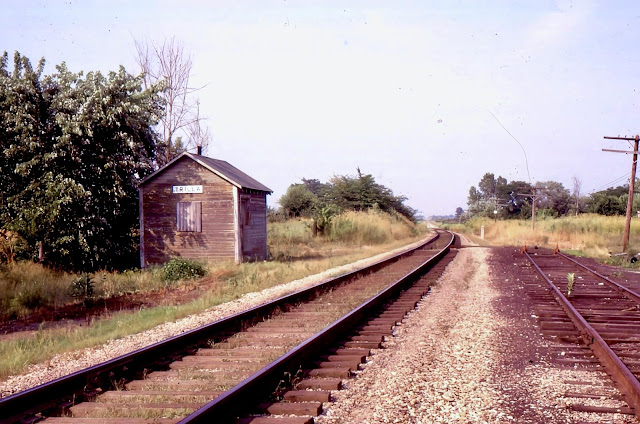
Trilla, IL: Lost Depot on EIRC/NKP/Cloverleaf Route

(Satellite, a very unconfident guess.)

EIRC = Eastern Illinois Railroad Company

Andy Zukowski posted
Nickel Plate Railroad Depot in Trilla, Illinois. 1966

If you look closely, one can see a slight curve in the tracks between State Street and the bridge. The depot photo must have been taken with a telephoto lens because the curve appears to bend more in the photo.
1960 Aerial Photo from ILHAP

Fortunately, Illinois has been uploading additional aerial photos because the late 1930's aerial was very confusing. For one, the shadow of the long looking building in the southeast quadrant of State Street and the tracks doesn't make sense.
1939 Aerial Photo from ILHAP

There is a long building there today.
Satellite

No street view driver has done the streets of this town, but I did find this view of the long building. Why would you build a new building with that roofline?
Street View, Aug 2023

It is a company that builds seed cleaning equipment and other agricultural machinery.
CommodityTraders


Frankfort, OH: B&O West Junction (BK) Tower: B&O vs. B&O/CHD

(Satellite, the photos indicate it was on the south side of the tracks.)

CHD = Cincinnati, Hamilton & Dayton

Darren Reynolds posted four photos with the comment: "Baltimore and Ohio Railroads    "BK" tower(West Jct.)    Near Chillcothe, Ohio."
Jeff Steinbrook: This is Musselman Station Rd. just east of Frankfort, Ohio it is where the lines from Cincinnati, Ohio and Dayton lines connected, they controlled passing trains here also, to where they could switch off trains onto the line which run up and through, North Fork and the Papermill onto Southern Ave. The old switchman's building sits on Cooks Hill Rd. someone paid to have it moved and put there.
Brandon Willis: Where exactly was BK tower?
1
A westbound passing "BK" tower on the St.louis main on July 8,1972
Photo by: David P. Oroszi

2
The Caboose from a Eastbound is passing by "BK" tower On July 8,1972
Photo by: David P. Oroszi

3
Looking West at "BK" tower Dec.1980

4
Looking West a B&O train is ready to pass the West Jct.
Switch at "BK" tower on July 27,1983
Photo by: Frank Garon Collection

Dennis DeBruler commented on Brandon's question
https://maps.app.goo.gl/zNPWPTZ1XUStACPC7 Even OH-100 is now abandoned across Paint Creek. The trail uses the Cincinnati, Hamilton & Dayton (CHD) route to the west to Frankfort and the B&O route to the east. Ironically, there is still a B&O bridge in the upper-left corner.

1961/62 Bourneville Quad @ 24,000

Apr 22, 1960 @ 24,000; AR1VAAX00050083

Digitally Zoomed

Minneapolis, MN: C&NW/M&StL and GN Cedar Lake Railyards

(Satellite)

Greg Smith posted
I made a number of air trips over the Twin Cities in the 1970's getting photos of all the railyards. We could rent a plane and pilot for about $25 per hour. This is looking west on Highway 12 (I-394 now) at Penn Av. Tha'ts the CNW/M&StL Cedar Lake shops, and the GN Cedar Lake yard in the middle. Some of the GN guys told me the GN yard was to assist in reefer cars with apples arriving from the west.
Tom Domres: We heard that this was a busy spot back in the day. Apparently ice would be harvested from the lakes and stored in ice bunkers. That ice would be added to reefers holding produce from the West.
Anthony Wood: Boy I'm so glad this was replaced by bike trails people don't use, single track main, light rail that's running in the wrong spot, and a service road people use as a trail instead.
[There are several more comments about the light rail project.]
Mike Boudreau shared
Started out as a laborer in this shop for six months then I got chance to move to being a fireman.

1952/54 Minneapolis South Quad @ 24,000

The M&StL had another yard to the northwest. I don't know if that was also Cedar Lake or if it had its own name.
1952/54 Minneapolis South Quad @ 24,000

I got an old aerial photo of the shops to confirm it had a transfer table.
May 8, 1947 @ 17,000; AR1DV0000040047

Tuesday, October 29, 2024

Coal Center, PA: Vesta Coal Mine #4

(Satellite)

Jackson-Township historical preservation posted
Tipple at Vesta Mine No. 4 near the town of Fayette City, Fayette County around 1930.
John Matty: Vesta 4 came out between California and Coal Center PA. Washington County side of the river.

Dennis DeBruler commented on the above post
June 18, 1952 aerial photo. Harrison Road is along the left side.
[Facebook flagged this comment as a violation of their Community Standard, so I deleted it so that they wouldn't put me in the jailhouse. This has to be an example of AI gone bad.]
[AR1UG0000020032]

Digitally Zoomed

We can still see part of the embankment on which the conveyor belt ran.
Satellite


Ohlman, IL: Lost/Big Four & C&EI Union Station

(Satellite)

Andy Zukowski posted
Union Railroad Train Station Depot at Ohlman, Illinois. 1908
Bill Edrington: Owned by the Big Four; C&EI had trackage rights from Pana to Granite City and its passenger trains made conditional stops at Ohlman at that time.
Dennis DeBruler: Bill Edrington Thanks, I wondered why it was a union station.
Bill Edrington: Dennis DeBruler - Technically I guess it was, but I suspect that if a stranger had asked somebody in Ohlman where "Union Station" was, they probably would have said "St. Louis."
Richard Fiedler shared
Keith Cearlock: Can you share please?
Dennis DeBruler: Keith Cearlock Private groups can't share. But if you click the photo you get to Andy's post, and that post can be shared.
Steven Hooker shared
Colin Harding: According to my 1940 Official Guide on the C&EI and Nickel Plate.
Dennis DeBruler: Colin Harding If you click the photo, you can access the comment by Bill Edrington. He and some maps indicate the tracks were owned by Big Four and C&EI shared the tracks and station. I wonder how the Nickel Plate was involved.

Dennis DeBruler commented on Andy's post
I'm glad I saw Depot Street because I had originally guessed a rectangle on the town side of the tracks. But when I looked again on this 1939 aerial, I could clearly see the platform of the depot. And Andy's photo shows there were no buildings behind the depot. https://maps.app.goo.gl/9j1JZEhJi1GUSVnR6