Mine: (
Satellite, northwest quadrant of Coal City Road and the Original Center Street)
Current Depot: (
Satellite)
 |
Roger Kujawa posted
Braidwood Illinois Real Photo Coal Mine |
 |
| Dennis DeBruler commented on Roger's post |
 |
Dennis DeBruler commented on Roger's post
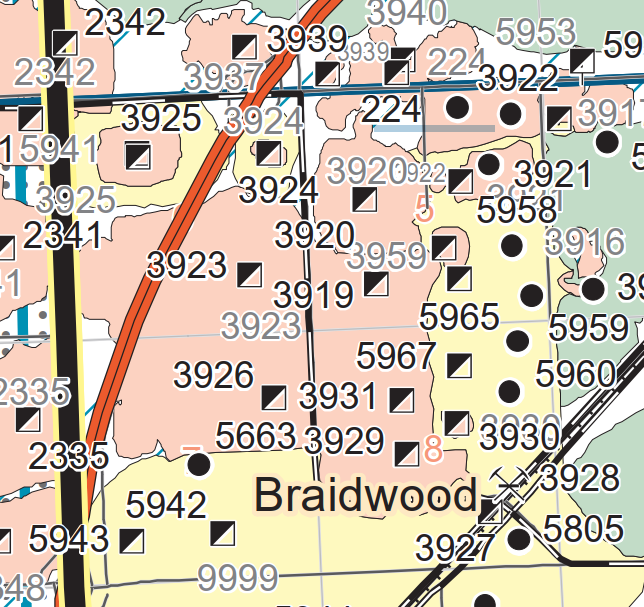
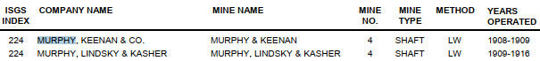
I think this mine was in the northwest quadrant of the intersection of Coal City Road and the original Center Street. I'm not surprised that I could not find any traces on a current satellite map because it has been closed for over 100 years. But I could not find the buildings on a 1918 topo map nor any trace on a 1939 aerial photo. And I could not find evidence of the other four tipples that are marked just north of Coal City Road. |
Things changed a lot in this area over the decades so each excerpt is the same area so that I can cmpare them. Specifically, the excerpts are from the Grundy-Will county line to Novy Road and from Coal City to Kennedy Roads.
 |
| 1892 Wilmington Quad @ 62,500 |
 |
| 1918 Wilmington Quad @ 62,500 |
 |
| 1954 Wilmington Quad @ 24,000 |
Depot and Water Tower
 |
HS House Camping posted
Circa 1904. "Depot at Braidwood, Illinois." 8x10 inch dry plate glass negative, Detroit Publishing Company.
David Partak: I believe the station still stands as historical site. William Shapotkin: David Partak Yes, it has been moved way from the railroad and is in BEAUTIFUL condition (at least as of five years ago).
Chicago and Alton.
Dennis DeBruler: I found the current location: https://maps.app.goo.gl/KyXZevrsDfUijDca8.
Joseph Obrien shared a different exposure |


No comments:
Post a Comment