#1: (
Satellite)
#2: (
Satellite, the trees along IL-149 south of the bigger clump was a railyard.)
Michael Tow
posted five images with the comment: "In 1903, Ed McGuire wrote to his friend, George Havens, back in St. Louis to tell him of the jobs available in the coal mines of Williamson County, Illinois. Havens left St. Louis in April 1903 for Bush, Illinois, and soon thereafter became top superintendent at Bush Coal Mine #1. Havens later worked at Bush #2 and the Pyramid mine south of Pinckneyville. George and Mamie (Coulter) Havens raised six children in Bush: three daughters who married coal miners, a son, Lawrence, who was killed in a mine explosion in West Virginia in 1937, and a son, J.D. (my grandfather), who worked in many mines across southern Illinois from Shawneetown, to Rosiclare, to Pinckneyville before dying of Black Lung in 1991."
 |
| 1 |
 |
| 2 |
 |
| 3 |
 |
| 4 |
 |
| 5 |
Bush #1, 1903-17, is Index 435, and Bush #2, 1916-28, is Index 147. I included Index 967 because that is part of
Burning Star #5, which I recently researched.
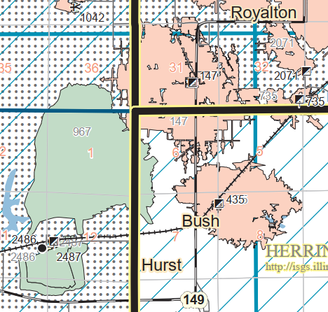 |
| Map |
A decade after Bush #2 closed, there were still some buildings and a railyard.
I'm lucky that one aerial photo caught both mines. We can see the industrial spur that served Bush #2. I presume they hauled the output of Bush #2 to the preparation and loadout facilities of Bush #1 that is near the lower-right corner of this excerpt.
Of note is the roundhouse in the railyard that was west of town.
The railroad was the SIMS, which became the Missouri Pacific. The branch to the southeast served some coal mines around Herrin, IL. MoPac abandoned that branch. UP now owns this mainline. I'm disappointed that this map doesn't include the roundhouse. Topo maps are normally pretty good about including them.
 |
| 1936 Herrin Quad @ 62,500 |


.png)


No comments:
Post a Comment