 |
| Brian J Hadley posted |
 |
| Satellite (Google) |
 |
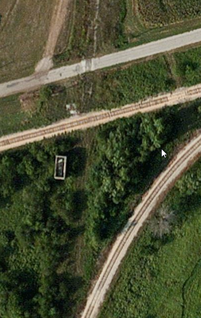
| Satellite |
The NYC line was the north/south line and it was called the Egyptian line because it used to extend the Kankakee Belt to Cairo, IL. It is now abandoned between Schneider and this junction. And many other segments south of here have been abandoned. The SPV Map indicates that the predecessor was Chicago, Indiana & Southern. The predecessor for the east/west NKP was Lake Erie & Western.
 |
| Eric Berg posted So after spending the last 40 years looking for a shot of this tower in service, I finally was led by Barry Lennon to these 2 taken by the New York Central in 1917. I also received a bunch of information on them, which I am going to write out below. Much thanks to the Allen County Historical Society of Lima, Ohio, specifically Charles Bates and Morgan Miller for their help in this matter. Here is the info I now have on this tower..... Valuation Department Information Owner: Indiana Harbor Railroad (CI&S, New York Central owns 100% per contract No. 541 with Lake Erie & Western dated June 1905) Division or Branch: Danville Valuation Section: 250 State: Indiana Nearest Station: Handy Year Built: 1906 By: Federal Railway Signal Co. Contractor: Charles Hansel Consulting Engineer Name and Use: Interlocking Tower Mile:81 Description: Two story frame slate roof, hip construction. Diagonal sheathing, siding-drop and shingles. Machine floor doubled. First floor is oak. No gutters or downspouts, interior ceiled with pins. I-beams for leadout platform not included in contract. Dimensions: 15' x 27' Plan File No.: Union Switch and Signal Co. Plan No. C-4067 I.H. R.R. Contract No. 545 of April 28th, 1905: Final voucher No. 1723 of May 1906. Contractor was paid an extra $128.00 on account of concrete foundation was carried deeper than contract. Expenditure Ledger Oct. 1914-page 176. Putting in new cement foundation for new heater. 5 sacks of cement, 18 sacks of sand. Indiana Harbor RR Crossing the Lake Erie & Western RR Location: Handy, Indiana Call Sign: "DY" In Service: December 30th, 1905 Operated By: NYC Maintained By: NYC MACHINE: 17 levers for 13 Mechanical & 4 power signals 9 levers for 13 F.P.Locks 5 levers for 5 crossovers 8 levers for 8 derails 39 working levers 9 spaces 48 lever-frame This photo shows the east side of Handy tower with the double-tracked NYC in the foreground, looking west down the LE&W Peoria division towards Illinois. The train order signal is for the LE&W and I don't believe Handy was a train order office for the NYC here. Photo was taken from the platform of the union freight house between the 2 roads. Passengers may have been able to transfer here, I don't know for sure. Freight goods could have been offloaded and sent from one railroad to the other. New York Central Handy Tower September 29th, 1917 Photo by the NYC Used with permission from the Allen County Historical Society of Lima, Ohio |
 |
| Mike Girdwain posted Abandoned Handy Tower on the kankakee Beaverville and Southern. |
 |
| Edward Krzyzowski commented on Mike's posting Spring 2016 |
 |
| Edward Krzyzowski commented on Mike's posting |
 |
| Edward Krzyzowski commented on Mike's posting |
 |
| Edward Krzyzowski commented on Mike's posting |
 |
| Locomotive Jordan posted I can't remember the date off the top of my head at the moment. Anyways we are at the interlocking of the N.Y.C.'s Danville Secondary with the former N.K.P.'s Frankfort, IN. to Peoria, IL. line. Both lines are now short lines. Both are operated by the Kankakee Beaverville & Southern Rwy., the former N.Y.C. is owned by the Stewart Grain Co. out of Stewart, IN. Their piece of the line is known as the "Bee Line Railroad," and operated by the K.B.S.R. We are at Handy, IN. That is the former N.Y.C. "HANDY," tower. The tracks are still in north of here, but are out of service. Photo was taken by Mark Stanek, it is out of my collection. Locomotive Jordan posted June 30, 1998, we are at Handy, IN. looking north at the connection of Bee Line Railroad with the Kankakee Beaverville & Southern Rwy. The north - south railroad was the former New York Central Danville Secondary crossing the east - west Nickel Plate Road Peoria District. Photo was taken by the late Mark Stanek, it is out of my collection. Mark Egebrecht: I believe 1989 was the year both routes were downgraded. N&W abandoned the Peoria District west of Cheneyville to Gibson City and sold the eastern segment to KBS. Conrail chased Soo Line off the NYC that year and forced them onto CSX trackage rights via Watseka and Terre Haute. David Jordan: Mark Egebrecht N&W pulled through trains PF-62 and FP-65 in November 1986, but maintained local service between Lafayette and Gibson City until the end of 1988. Richard Hertz: What a coincidence, I was just there for the first time on Monday on my way to Watseka IL. To see UP 4014. Amazing how incredibly overgrown that area is now, I couldn't even fight my way to the tower in the clothes I had on. Among the interesting things I saw, the crossbucks for the road crossing are still there, as are the eastward and westward stop signal poles, although only a portion of the eastward signal remains. The diamond is laying in the weeds with a tree growing through it. To see how substantial this interlocking was back in the day, go to the North American Interlockings website, go to the Indiana section and scroll down to Handy. There are a couple of pictures but of more interest is a diagram of the track layout dating back to 1905 when the tower was built. |
%20Abandoned%20Rails%20_%20June%2030,%201998,%20we%20are%20at%20Handy,%20IN%20_%20Facebook.png) |
| Comments on Jordan's second post |
 |
| Scott Janz commented on Jordan's second post May, 1987. Unknown credit. |
 | |||
| Eric Berg commented on Darren's share | Eric Berg | Top contributor | Original Handy tower, also looking north. |
I made the photo larger to better see all of the signalling pipelines.
 |
| Photo Doubled |
Bob Kalal posted ten photos with the comment: "in between Talbot & Ambia Indiana, Handy Tower.
North South was NYC, still heads South from here to Tab & Stewart. East West was New York Chicago and St. Louis, Now KB&S, heads west to Cheneyville & East to Lafayette."
 |
| 1 |
 |
| 2 |
 |
| 3 |
 |
| 4 |
 |
| 5 |
 |
| 6 |
 |
| 7 |
 |
| 8 |
 |
| 9 |
 |
| 10 |
Locomotive Jordan posted 13 photos with the comment: "Handy Tower at Handy, IN. March 03, 2021. This was the crossing of the New York Central Danville Secondary - Egyptian Line with the Nickel Plate Road Frankfort, IN. to Peoria, IL. line. Handy was abandoned by Conrail. However the east-west former N.K.P. Line is owned and operated by the Kankakee Beaverville & Southern Rwy. South of the tower there is a ten mile short line known as the Bee Line Short Line owned by the elevator in Stewart, IN. The Bee Line is switched by the K.B.S.R. Mostly grain and fertilizer. Somewhere I have another file or two of this tower to share when I find them. I will label the individual photos after they are posted online to this group."
[It is a public group, please use the link to access the photos.]
No comments:
Post a Comment