|
| Tim Starr posted Smaller railroads like the Chicago and Alton often had one large primary back shop facility rather than several smaller one to consolidate workforces and save money on supply and logistics. |
A different colorization.
 |
| Jimmy Fiedler posted |
 |
| Brian Falasz posted |
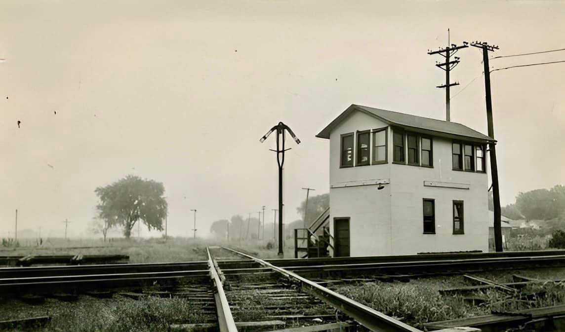
It is very easy to find this GM&O/Alton yard on a 1940 aerial photo. The above view is facing in a southerly direction.
 |
| 1940 Aerial Photo from ILHAP |
 |
| Satellite |
 |
| Mitch Anheier posted C & A Shops... Bryan Flick shared [The track gang is another reminder that it took a lot of people to maintain all that track with just hand tools.] |
 |
| Satellite |
The Sanborn Map is too big to include at a resolution that is readable. So I marked up the aerial photo with info from a Sanborn Map. (for my reference)
- brown: acetylene gas plant and tanks
- yellow: wet paper pulp factory
- red: cabinet shop
- green: formerly car shop. The bottom building was the paint shop. There was a transfer table between the two buildings.
- purple: storage lime & cement
- orange: Electrical shop
- dark blue: office
- light blue: steel car shop
I learned while studying IC's Burnside Shops that the gas from the acetylene plant is probably piped to the other shops to support the welding stations. I wonder what is done with "wet paper pulp."

 |
| Matt Smith posted Another great shot from the Pantagraph Archives. An aerial shot of Bloomingtons west side. Probably the most clearest and complete shot of west side rail operations I've seen! [This yard would be the big one in the center background.] |
 |
| Ted Lemen -> Gulf Mobile & Ohio Fans Worldwide |
 |
| Larry Miller III shared Tom Gregg's photo Jimmy Fiedler also posted [Note two water towers and coal tower on left. I believe the roundhouse is near the right.] |
 |
| Adam Elias posted Bloomington Yard on 3/12/16 |
 |
| Roger Holmes posted I sure miss the GM&O! I worked in the machine shop, that large building, for ten months as a machinist apprentice after I graduated from high school in 1967. Then I worked mostly summer jobs while in college as a relief agent, operator and leverman, working every open tower between Chicago and St. Louis with the exception of Bridgeport. This photo was taken from the West Locust St. bridge in Bloomington in the late 1960's. Please note in the lower left the Ingalls 1900 waiting to go north to be traded in to EMD. Oh, I almost forgot to mention, the shop powerhouse had the largest steam whistle in the state of Illinois on its roof...largest including the Great Lakes freighters...it was, along with a couple of smaller whistles to its side, the fire whistle which was blown in case of a fire in the large shop complex. I was a member of the force while an apprentice. As payment we each received a GM&O annual pass, good on 4 of the 6 passenger trains, and half fare on rail lines going west of Chicago, which I took advantage of when I went to Denver in 1968. The whistle, by the way, survives. It is on display next to NKP 639 in Miller Park in Bloomington. The display says that it was the regular shop whistle that blew for the daytime shifts, which is incorrect. © Roger A. Holmes |
 |
| McLean County Museum of History posted Chicago & Alton Railroad yard, December 1939 This was the scene in late December 1939 on Bloomington’s west side. Back then, the C&A Shops and adjacent yards were a city unto itself with hundreds of workers maintaining and repairing locomotives, refurbishing and constructing rolling stock, shunting freight, and doing all kinds of other fascinating stuff. Richard Fiedler shared |
 |
| David Lucas posted I was just browsing pinterest and came across this excellent photo of the Chicago & Alton roundhouse and engine repair shops in Bloomington, ca 1931. There was no attribution noted; so, I don't know who took this photo. Phil Clark Gotta love that organization and balance of railroad yards. Jimmy Fiedler I wonder in its time was this the biggest railroad shop complex in Illinois? Maybe silvis? Kerry Doyle Site of first rr sleeper car construction? Bryan Flick shared |
 |
| Brian Falasz posted |
Ben Fehr posted four images with the comment: "The long-abandoned and mostly demolished Chicago & Alton shops in Bloomington, IL. Historical photos by The Pantagraph."
Sean Parker: Pretty crazy they went through all the effort to tear the buildings down only for the land to sit idle.
Chase Withrow: Sean ParkerIf the buildings are standing the tax man is earning.
Andy Baumann shared
Chase Withrow: Infrastructure is not free. The Pennsy roundhouse in Crestline was a one of a kind facility still sound in 2005. It's overhead crane when around to roundhouse ! One teenager trespassing was all it took to see it raised to the ground. As long as it stands you have to make sure it's secured. Liability never steeps.
 |
| 1 |
 |
| 2 |
 |
| 3 |
 |
| 4 |
 |
| Carl Venzke posted Looking north on train tracks from Locust Street bridge in Bloomington, Illinois on November 7, 1959. A southbound Gulf, Mobile & Ohio train approaches Bloomington railroad station. Photo by Barry Lennon [A nice view of the ladder track for the claissification yard.] |
 |
| John Morris posted View of the GM&O's Bloomington yard and shop facilities, including the old Chicago & Alton main shop building. Sadly, this historic building was not saved. I took this photo in the mid-1960s with my father's old 116 Kodak camera to see if it still worked...obviously, it did. Patrick Provart This is taken from the east end of the old Locust St. Bridge, about a block east of St. Patrick's church. 5 or 6 miles west of the mall, but only a couple blocks off Route 9 |
 |
| Andy Zukowski posted In early 1978, a quartet of GM&O F3s are in the dead line outside the ancient diesel shop in Bloomington, Illinois. Fortunately, all four units would head to the Paducah Shops to be rebuilt into FP10s for the MBTA. Photo by Joseph Petric Thomas Scott: At about this time, the Monticello Railway Museum asked the ICG for the donation of a GM&O F3. ICG decided the F3's were more valuable as rebuilt locos than a tax write-off, so the request was denied. |
 |
| Randall James commented on Andy's post 807B was the last GM&O F3A to be repainted in it's full 2 tone paint scheme 1966 at Bloomington |
 |
| Brian Falasz posted Another great picture inside the backshops in Bloomington, IL. The more you look, the better it gets!!! Dennis DeBruler: Indeed it does. It shows some line shaft driven equipment. Line shafts were made obsolete by low-horsepower electric motors around the interesting turn of century. Brian Falasz: Dennis DeBruler I was hoping someone would spot those!!! Dennis DeBruler: This has some photos that shows what line shaft factories looked like back before electricity was developed: https://industrialscenery.blogspot.com/2016/11/jack-shaft-and-leather-belts-revisited.html. They were developed when water wheels were the source of power. Then steam engines powered the shafts, followed by large electric motors. Eventually, small electric motors on each machine made the line shafts obsolete. Line Shaft and Leather Belts INDUSTRIALS |
 |
| Tom Cherry posted 1901 Sanborn Fire Insurance Map of a portion of the Chicago & Alton Yard, north of Chestnut St. The Sanborn Maps were originally created for assessing fire insurance liability in urbanized areas in the United States. [Chestnut has been renamed Lotus Street. Note the transfer table next to the erecting room.] Mel Theobald Tom Cherry, this is incredible. So many of those buildings changed after GM&O converted to diesels in the 1940s. I've seen other photos that show a 2nd turn-table which later disappeared. This answers a lot of questions. Among others: the Machine Shop later blended in with the Locomotive Shop; the Boiler Shop became the Engine (Fuel) House; and the Coal Shed was replaced by the Wheel and Axle Shop. One of my favorite details is the Sand House. I worked there in Dec. 1967. The "hobos" would volunteer to do our work if we would let them sleep on the warm sand piles. But that's another story. Thanks for posting. |
 |
| Mel Theobald enhanced a comment by Andy Streenz on Tom's posting The Bloomington rail yards as of 1953, according to this Sanborn Insurance Map. |
 |
| Tim Starr posted The primary shops of the Chicago & Alton were at Bloomington IL. Here is the layout after a renovation and expansion project in 1902 that modernized the shops built in 1883. [It had two transfer tables.] Tim Starr posted to a different group The Chicago and Alton shops at Bloomington IL hosted 3 roundhouses, although not all at the same time. In this 1902 shop renovation project, the original roundhouse was being used as a repair shop, while the North Roundhouse of 44 stalls was more modern and used as the terminal. The third and final roundhouse (not shown here, 46 stalls) wasn't built until 1910. (Railroad Gazette) |
 |
| AgRail |
 |
| COURTESY OF THE McLEAN COUNTY MUSEUM OF HISTORY from pantagraph (source) Looking northeast in the 1930s. |
 |
| Richard Fiedler shared |
 |
| Brian Falasz posted looking northeast east |
 |
| Brian Falasz posted Overhead view of the Roundhouse in Bloomington, IL. It was on the far west side of the shops/yard complex. |
 |
| Brian Falasz posted Another picture of the C & A shops (probably G M & O or ICG by the time this was taken) on the west side of Bloomington, IL looking north from Locust street. This has to be after 1967 as Watterson Towers on the ISU campus is visible in the upper right hand corner of the picture. |
 |
| Mike Breski posted Circa 1904. "Chicago & Alton Railroad shops at Bloomington, Illinois." At left rear, the Anheuser-Busch beer boxcar. Dave Durham posted C&A shops, Bloomington. Unknown date, Detroit photography co. Alan Fricker: Well, I think I can put a date span on this photo. The Detroit Photographic Company was in business from the late 1890s until filing for bankruptcy in 1924; going out of business in 1932 or thereabouts. They used this name, Detroit Photographic Company, until 1905. So the photo was most likely taken between 1897 to 1905. Thanks, Wikipedia!
|
 |
| Mitch Anheier posted Alton Railroad Victory railroad car 1942.... Greg Koos Freshly painted at the shops! BHRS shared Dennis DeBruler A view of a transfer table. |
 |
| Jon Martin posted Thomas Dyrek The roundhouse burned in an arson fire in 1972 which destroyed 33 out of the 44 stalls. The remaining stalls were destroyed by a second arson fire in 1973. Jeff Ramsey When did the blacksmith shop get demolished? Thomas Dyrek Jeff Ramsey 1990. Mike Martin Jon, a limestone block from one of the shop building’s is in the backyard at Mom and Dad’s by the tree!! Warren Caudle The old joke about Bloomington is that you are near Normal when you are there. |
 |
| Dave Durham posted |
 |
| Brian Falasz commented on Dave's post This was a picture taken inside the remnants of the car shop about 1986. All of the buildings are just a memory except the freight house. |
Brian posted a couple of images of a blueprint that he has with the comment: "as promised here is a picture of the layout of the Shops area in Bloomington, Illinois. Title block in the upper right hand corner says this was originally drawn in 1932 and then revised in 1954. This would have been the GM& O era of ownership as also stated in the title block. Locust Street (W) (Illinois Route 9) is on the left, Emerson street (E) is on the right. There was an additional classification yard to the East of Emerson Street as evidenced by the number of tracks under the street bridge." But Facebook allowed a height of only 960 pixels.
 |
| 1 |
 |
| 2 |
Tim Starr posted two images with the comment: "Diagrams of the new coal facilities at the Chicago and Alton terminal in Bloomington IL, 190. (Railway Age)"
 |
| 1 |
 |
| 2 |