Roundhouse: (
Satellite)
 |
Richard Bruehahn posted
I’m originally from Oelwein Iowa. This is where most of my collection of photos are from. This is an overhead view of the repair shops of the Chicago Great Western and later Chicago Northwestern Railroad before they were torn down. The building with the brown roof on the right is still there but the long building on the left is gone. I also have photos of some of Marquette Iowa Milwaukee Railroad yards. Will do some more posts later.
Richard Bruehahn posted again
Aerial view of the CGW/CNW shops in Oelwein IA. The large was torn down a few years back but the smaller one in the center is still there. |
 |
Tim Starr commented on Richard's second post
Nice! I haven't seen this photo before. This diagram of the shops is from 1900.
Richard Bruehahn: Tim Starr it’s not in the photo but there used to be a transfer table on the right side of the big building. Don’t know when it was removed. |
 |
Tim Starr commented on Richard's comment
Looks like it was still there in this 1950 photo from Hub City Heritage but I don't have any photos from the 60s or 70s. |
Marty Bernard
posted four photos with the comment:
Four aerial photos of the Chicago Great Western's Headquarters and Primary Shop. Walter Dunlap collection
In 1892 the city of Oelwein, Iowa was chosen as the CGW's headquarters and primary shop site due to its central location on the mainline.
Part of the Oelwein roundhouse is still used by a freight car rebuilt business. The rail line to Waterloo serves it.
 |
| 1 |
 |
| 2 |
 |
| 3 |
 |
| 4 |
 |
Marty Bernard posted
CGW Shops, Oelwein. IA Postcard, Aug. 17, 1919. Walt Dunlap collection |
 |
Allen Troupe posted
The CGW Roundhouse in Oelwein today (taken 24 Oct 2016). |
 |
John Mann posted, cropped
CGW roundhouse in Oelwein, IA June 2025 |
It looks like it was used until recently by Transco Railway Products. This is the first time I have seen a turntable replaced by a bunch of turnouts.
Update:
 |
History's Mirror posted
The Chicago Northwestern's Oelwein, Iowa Shop Complex, photographed in August 1985, was a significant site for railroad operations in the Midwest. The complex played an essential role in maintaining locomotives and rolling stock, ensuring smooth operations for both freight and passenger services. The tracks in the photo show the main routes from Oelwein: the left track led to Waterloo, Iowa; the center track went toward Minneapolis, Minnesota; and the right track, originally connecting to Dubuque, Iowa, was an important part of the network. At the time, Oelwein’s shop complex was one of the major facilities for the Chicago Northwestern Railroad, which served as a key player in connecting the Midwest. While the photo itself lacks a credited photographer, it offers a valuable look at the infrastructure that supported the vast railroad network of the era. The image, likely shared by a collector on eBay, captures a moment in history when smaller towns like Oelwein were integral to the success of the railroad system. The complex is now part of railroad history, but photographs like this continue to preserve the legacy of railroad towns and their contribution to America's industrial development.
Mark Henschel shared
Berne Ketchum: It’s hard to tell for sure, but I’d guess this photo was taken about the time the CGW dieselized in the late ‘40s. I can’t see the yard offices and new tower, nor the nice depot that were fairly new when our family moved to to Oelwein in 1953 when my dad, Paul Ketchum, (PMK) became a dispatcher. The diesel engine house doesn’t seem to be there either. The depot, built in around ‘49 or ‘50 is Oelwein’s city hall now, I believe. [It sounds like the date is off by a few decades. C&NW bought CGW in 1968, so the date is important. Some comments indicate that the shops were used until 1994 and torn down in 2011. The shops did work for other railroads.] |
 |
Marty Bernard posted
Rick Burn found Chicago Great Western 63A and 63B (TR2A and TR2B -- affectionately call a Cow and a Calf) in Oelwein, IA in March 1967. Note, the Calf has stacks because it is a fully functional switcher but without a cab. A Slug on the other hand is usually a big chunk of concrete with traction motors powered by it's Mother.
Bob Davis SP had four EMD "Cow and Calf" sets. One of the "Cows", TR-6A 1100 is preserved at the Western Pacific RR Museum.
Berne Ketchum At the right is CGW R-1, the boxcar converted to a mobile classroom in which Rules Examiner D.J. Gifford conducted rules classes and examinations. Giff had earlier been a dispatcher.
James Belmont Union Pacific assigned two sets of TR5 transfer switchers to Provo, Utah in the 1970s.
https://flic.kr/p/214nPFu |
Kirk Brust
posted three images with the comment: "
Here is the Chicago Great Western Roundhouse in Oelwein, IA. Ground photo is mine, about 2007. Aerial views Bing maps."
Sam Hill Just asking.... did originally have a turntable or was it always like this ?
What’s the history?
 |
| 1 |
 |
| 2 |
 |
| 3 |
 |
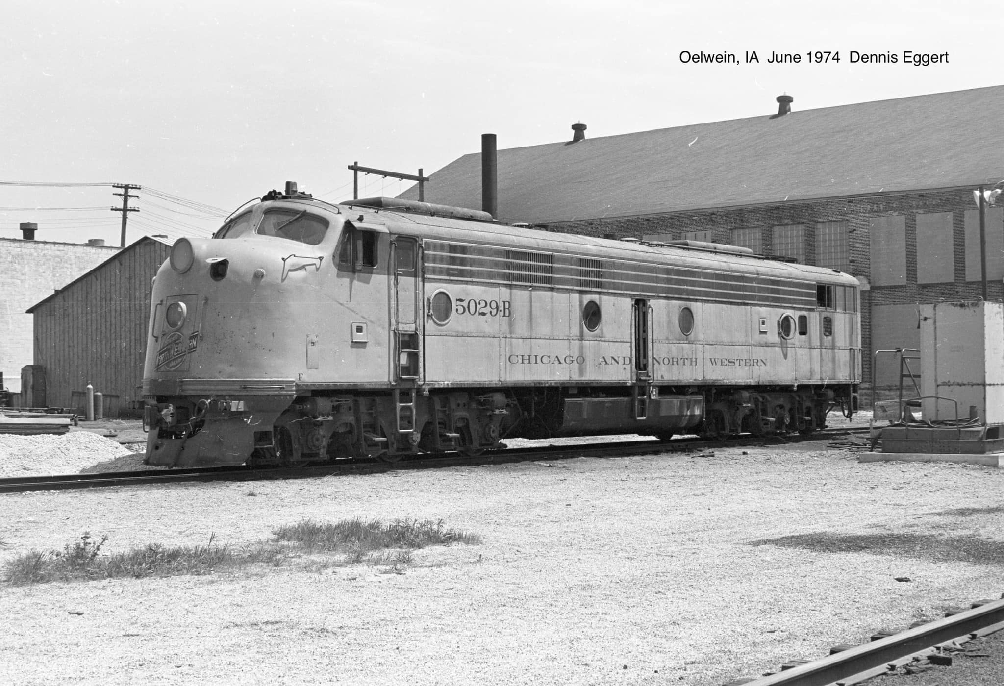
Dennis Eggert posted
Several F-units were on the ready tracks at Oelwein. They were the primary power used on the former CGW lines.
Don Heddinger: They were a bitch to use doing 'station switching', and tough to get in...with or without a grip. Warmer than geeps in the winter and hotter than hell in the summer. Walk back through the engine room and the soles of your boots were coated with oil and your ears were ringing. Worked 3 or 4 years with them but would have preferred geeps... |
Marty Bernard
posted four images with the comment: "Rick Burn took these Chicago Great Western scenes in Oelwein, IA in March 1962. Rob ONeill just found the third picture. Now I've added a fourth photo. We have been talking about two different places!"
[Rick's photos would be of the car shop.]
 |
| 1 |
 |
| 2 |
 |
| 3 |
 |
| 4 |
 |
Dennis DeBruler commented on Marty's post
Evidently UP did not sell the car shop land to Iowa Northern. |
 |
| 1981 Oelwein Quadrangle @ 1:24,000 |
 |
Tom VanZuiden posted
I took this in Oelwein back in the days when you could wander most anywhere with no hassles, sometime in mid '90's is my best guess. I climbed on top of a unit to grab this shot. Can anyone help me date it more specifically?
Kevan Davis: CNW’s answer to the grain surge. When it hit they would pull what they needed out of the line and get it out there. By the time the old junk broke and came back they would have more old junk running to take their place. |
C&NW got CGW on Jul 1, 1968.
3 of several photos
posted by Dennis Eggert:
 |
a
This shows the area north of the shop building. 206 and 1082 were probably out of service and served as a source of parts for other similar engines. |
 |
b
1022 was originally CGW 20 and was still wearing its CGW paint. It was renumbered to 1022 in 1973.
Dustin Smith: 1022, exCGW 20 was the 3rd to last CGW NW2 in original EMD paint. It was repainted in either the last half of 1974 or first half of 1975. Only CGW 18 and CGW 25 lasted longer in this paint scheme. |
Jim Kettler
posted the question: "Was the Ice House in Oelwein a poor investment for the CGW?"
Doug Albright: Not according to the old head's I worked with in Olewien in the 70s. Loaded car after car. The track held 20 something cars.
Dustin Smith: Assume you are referring to the 1950s built ice plant and car icing facility. And not the 1920/30s built ice house.
While I have heard many subjective opinions, from non-railroaders since early 1990s about how the new plant shouldn't have been built, I grew to understand why it was built as part of the CGW centralization plan, as a replacement for an existing structure that was not easily utilized, nor convenient for switching cars or for servicing the cars with ice. The old building also needed extensive repairs.
Mechanical refrigeration in RR cars was also not in widespread use when the new facility was built. Keep in mind livestock was also still being transported live by rail. And there was stock pens built near the North (or sometimes referred to as Western) yard lead/yard office that my great and great grandfather were part owners. Lots of things change in the meat processing industry, that would then change the railroad industry many years later. Railroads had to support both ice and mechanical refrigeration for an unknown period of time.
Thomas Kaufman: Remember, before mechanical refrigerator cars cooled by other means, the reefer cars were loaded manually with ice in major terminals and that was the only way to keep food cold in transit. Oelwein had a large ice house that held 20 cars as Doug said. In the 40's, 50's, and 60's, the Chicago Great Western was the means a lot of the meat packers in Iowa transported their cars of dressed beef, to Chicago. The CGW had a connection at Bellwood with the IHB, and they transported the cars through Chicago to eastern connections. There was a long standing 1:30 pm drop off to make sure that happened.
Greg Morrill: In the 60's Ice was still loaded in the older refers, but that was petering out. I from the switchmen I knew thought it was a big joke. Some more of the Deramus modernizing of the CGW. The snakes thought it was job security though! It served its purpose for a limited time!
Leroy James: Greg Morrill My dad worked at both the old and new ice houses and I was inside both of them and remember how they operated. The new ice house was built in 1951 as one of my teachers that year told us that her husband was working for the well drilling company that was drilling the well for the new ice house. I think at the time it was considered a good idea to build it as 8 or 10 men worked at the old icehouse where only 2 men were required at the new one. Also in the winter time when they filled the ice house quite a few additional men were hired to unload the cars of ice and place it in the house which took about 2 months, Also a company in Waterville MN was hired to cut the ice from the lake and load it into box cars and some times in stock cars, 2 layers of ice in each car. The new ice house made the ice right there, so you see there was a huge savings in labor, The old ice house was located on the SE edge of Oelwein and some of the cars to be iced would have to be taken by the switch crew down to the ice house and then wait for them to be filled and so that took away their time switching in the yard. The new ice house was located on the west side of the yard and the switch crew could spot the cars at the house and then go back to switching and then go back later to get the iced cars. A car of ice was kept down at the depot for ice for the passenger trains in the summer.
After the Oelwein ice house was shut down the CNW tried to sell the deep well to the city but could not get together on price. I never heard if later on the city got the well.
 |
Mark Llanuza posted
Its June 1980 a view of the [CNW] former CGW Oelwein Iowa shops and Diesel facility |
 |
Garry Bahe commented on a post
Here is ours in Oelwein IA it’s Transco rail car shop. Was an old Chicago great western Roundhouse. I worked there for 47 years.
Dave Kuntz Drone Photos: looks like it still has rail access there as well? Garry Bahe: Dave Kuntz Drone Photos yes we took over the yard 24 miles of rail in it. We blasted and painted cars in it. Built new blast and paint in 2016. New tank wash and 3 new shops there going strong.
|