Showing posts with label canalWE. Show all posts

Sunday, March 19, 2023

Warrick C: Chandler, IN: 1973-1993 AMAX Ayrshire Coal Mine and B-E 3270W & Marion 8950

Coal mine: (Satellite, between I-69 and Pigeon Creek. Given the long "lake" on the west, they dug from east to west. Note that this mine is no where near Ayrshire, IN.)
Tipple: (Satellite)


Mark Bowles posted
Marion 8950 at Amax Ayrshire mine 1994 300 foot boom 150 cubic yard bucket. Marion's biggest dragline. When I took this picture the 3270 was about 2000 feet directly behind me .at the time the two biggest draglines in the word setting beside each other.it was pretty cool.
Troy Shane Bratcher: That machine was 6 years older than the 3270.

James Stine posted
Shown here in this photo is the Bucyrus-Erie 3270-W on the left and the Marion 8950 to the right. These draglines, the second and third largest in the world at the time, worked at the Ayrshire Mine located north of Chandler, Indiana.
his mine operated from late 1973 to around 1993. The Marion 8950, with a 310 ft. boom and a 150 yd. bucket, was scrapped shortly after the mine closed. The B-E 3270W, with a 335 ft. boom and a 176 yd. bucket, sat parked at the mine for several years before being scrapped. Photo courtesy of Jon Koenig Collection.
Troy Shane Bratcher: Even though the 3270 packed 26 more cy bucket the boom looks fragile compared to the 8950's boom
Ricky Cates: Peabody came close to buying the 3270 from Frontier(who owned it at the time), they were getting ready to sign the papers when somebody from Frontier asked somebody from Peabody where they were going to use the 3270, assuming it was going to be the Midwest, then the person from Peabody said , we're going to tear it down and take it out west, Frontier back out of the deal and refused to sell the 3270 to competition out west.
Jerry Lacy: Not trying to take anything away from it but wouldn't the 8950 have been the fourth biggest at the time,big musky,both 3270s then the 8950.
Zachary Southard: Which machine had a fatality as they cut it down?
Michael Herr: Someone died while the marion was dismantled. I think he was hit by one if the cables if i remember right.
[I had read that someone was killed at Ayrshire when a cable snapped. And the comments describe some fatal incidents during operation.]
Mark Bowles: Just think . a museum with a 3270 8950 and a 5900 . Second and third largest dragline and 3 rd or 4th largest shovel.

 
Scot Perry commented on James' post

Scot Perry commented on James' post, cropped

This is one of my favorite dragline photos because the church steeple illustrates how unbelievably large these cranes were. The steeple provides a better scale than a tiny person or pickup at the base of the crane.
Stine James posted
I thought I would add this photo of the 8950 next to the Church at the AMAX Coal Ayrshire Mine. The photo comes from the Jon Koenig Collection.
Robert E. Wetherington: I designed the boom for this K89501 Dragline. It's Allowable Load was 775,000 lb including the bucket.
Troy Shane Bratcher posted
Here's the picture of the 8950 at Ayrshire.
[This is the smaller dragline.]
 
James Stine posted
I believe this photo to be from the Coal Age, I think we posted this last year, but thought I would put it up again, an aerial shot of the AMAX Coal Ayrshire Mine located just to the northwest of Chandler, IN. Here in this photo, the mine is still somewhat new and was on of AMAX' flagship mines in the early 1970's. A Marion 8950 and B-E 3270W worked this site, thus, the second and third largest draglines in the world at time.
Will Ward: The other 3270 was at the AMAX Delta Mine in Williams County in Illinois. Delta had a 1450 and an 8750 as well. The 1450 slid off the bench and into the pit. It was completely wrecked.

Google Earth, Mar 1992
[That is a remarkably high resolution satellite image for 1992.]

Google Earth, Mar 1992
[A dragline is in the lower-right corner. I included the interstate exit to identify the location. My parents lived in Evansville and now I wonder how many times I drove past these draglines without knowing it.]

Google Earth, Mar 1992
[The other dragline was near the north end of the mine.]

Jeri Casson posted
I found some old photos in my desk this morning. This is the 8950 and the 3270 at Amax Ayrshire mine near Chandler IN.
William Oldani: That is a Classic Picture! Marion’s Largest Dragline and BEs Largest Production Model!
 
James Stine posted
Here in this photo, we see the Marion 8950 with it's 310 ft. boom and 150 yd. bucket working closest in the photo. The B-E 3270W is working in the background with it's 330 ft. boom and 176 yd. bucket. These machines were at the AMAX Coal Ayrshire Mine with the 8950 starting in 1974 when the mine opened and the 3270W being added in 1979. The mine run into the early 1990's when it was shut down. Both machines were scrapped at the site with the 8950 falling first shortly after the mine closed and the 3270W some 8-10 yrs. later. The photo comes courtesy of the Jon Koenig Collection.
Kim A Phalen: James I think there were two 3270 's right? And how many. 8950's ?
Jeff Durall: Amax Delta mine had the sister 3270 and Ayrshire had the only 9850 made. the best I can remember.
Troy Shane Bratcher: That's right Jeff, Marion only built one 8950

Stine James posted
Shown here in this Jon Koenig photo, AMAX Coal's Ayrshire Mine's Marion 8950 dragline in the forefront and the B-E 3270 in the background. During the 1980's, these machines were the second and third operating draglines in the world. The 8950 carried a 310 ft. boom with a 150 yd.bucket and the 3270 carried a 330 ft. boom and a 176 yd. bucket. This mine was located to the northwest of Chandler, Indiana.
Nick Granderson: Was parked in early nineties and scraped in I believe 2004.

Troy Shane Bratcher posted
Probably my favorite of the big machines Marion 8950 at AMAX Ayrshire mine southern Indiana.
Mark Greer: A man was killed during the tearing down of that dragline. Decapitated by one of the cables that was under tension when he cut it with a torch.
Connie Kucinski: Was there a shovel call the Monnigan, or am I dreaming???
Stine James: Connie, Monighan Machine Company, along with John W. Page, were the first companys in the walking dragline business. Bucyrus purchased controlling interest of Monighan Machine in 1931 and took it over by 1934. Bucyrus called their draglines Bucyrus-Monighan until 1946, after which they dropped the Monighan name for the name Bucyrus-Erie.
[There are three more photos in the comments. Another comment indicates the Big Muskie (B-E 4250W) was twice as heavy and had a 220 cyd bucket.]

Troy Shane Bratcher posted three photos with the comment: "BE 3270 from a coal mine just north east of Evansville Indiana."
1

2

3
Troy Shane Bratcher posted
Travis Hill: The 32's were beautiful machines!
Jay Wilson: The 2570WS has a lot of design features that these machines had, doesn't it ??

Map
AMAX Coal Co., 1973-1989 (End date varied between 1986 and 1993.)
Danville and Hymera Coal Members (seams)

Map Clicked

1980 Daylight Quad @ 24,000

1988 Daylight Quad @ 24,000

I happened to notice "Tow Path Rd." So the Wabash and Erie Canal came south along the east side of Pigeon Creek. I included the canal in the topo maps.
Satellite

Mim Turphy posted four photos with the comment:
With all the pics of Ayrshire 3270 and 8950 this past week, I thought I would share my LEGO models of the two.  These are 1/198th scale, custom designed and built by me, and the 3270 is fully motorized.  It swings, walks, drags, and hoists!  The big steel ball in the middle is an actual ballast ball bearing from the Delta 3270 with a roll of tape for scale! Enjoy!  
P.S. these are "one offs" that took me a few months and several hundred dollars each to build.  I am not able to build "copies" for anyone.  Sorry!
1

2

3

4

5:49 video of the Marion 8950 and of the tipple. Also a smallish front shovel and coal haulers.

Monday, December 27, 2021

Fort Wayne, IN: Mayflower Mills Grain Warehouse and Elevator

Old: (Satellite, address from caption in FireFighter-v5_2119)

"New" in the above satellite label is relative. It was built in 1912, and it probably has been a long time since this facility stored grain.

The research of Mayflower Mills was motivated by this post:
Barbara J Anderson posted, cropped
This is currently Jackson Oil and Solvents, can anyone tell me what it used to be? (Leesburg Road, near to St Francis)
[Of the several answers, Mayflower Mills was the correct one.]
 
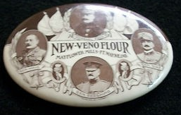
This proves that they milled flour.
And they had more than one brand of flour.
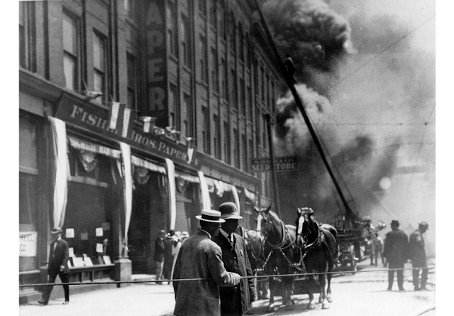
Their original location was downtown by the Wabash & Erie Canal. The right-of-way of the canal is now occupied by the NS/Nickle Plate railroad. This fire is another reminder that grain dust is very flammable.
Allen County Public Library
Fire at Mayflower Mills, Columbia Street between Calhoun and Harrison, Fort Wayne IN, 21 May 1911. Includes Fischer Bros. Paper, and seed store.

Is this the side of the building that faced the canal instead of Columbia Street?
Allen County Public Library
Mayflower Mills, Fort Wayne IN: 1913. reproduced from a printed source.

The 1913 photo must have been of the remnants of their old location because after the $125,000 May 21, 1911, fire, Mayflower Mills rebuilt at the new location. [FireFighter-v3_1535] Concrete silos would have been a relatively new development in 1912. It appears that their old location was a grain warehouse instead of an elevator because grain was handled in bags during the canal era.
FireFighter-v3_1536

FireFighter-v5_2119

Evidently Mayflower Mills was still grinding flour in 1968.
FireFighter-v3_1491

Mayflower Mills was on a 1972 list of buildings that were too tall to reach all of the floors with a ladder truck. [FireFighter-v4_1795]

3D Satellite

Street View


Saturday, July 25, 2020

Fort Wayne, IN: Wabash & Erie Feeder Canal

Water was diverted from the St. Joseph River with a dam a few miles upstream.

I knew the feeder canal quit following the St. Joseph River north of State Street because the canal was west of Centlivre Brewing whereas the river was east of it.
Photo from Kenneth Childers' posting
But I did not realize that it went so far west. And I did not realize that the NKP left the canal's right-of-way because the main canal bent sharply south. The feeder canal joined the W&E Canal north of Wayne Knitting Mills.
Tommy Lee Fitzwater posted
Jesse Dominguez So that aluminum place was wayne knitting mills? I think that feeder canal went right over or near my house.
Bruce Flohr Lots of the feeder bed is still visible, especially behind Concordia College. Where the feeder started at the St Joe [Robison Park] was the summit - the highest point on the Wabash & Erie Canal system - and thus the Fort’s nickname!

Jesse Dominguez commented on Tommy's post
I found an older map and it looks like I was right saying it went pretty much over my house lol
I heard beavers were the downfall of the canals though.
Nancy Parker Railroad put an end to canals,faster.
Bruce Flohr Jesse Dominguez trains came along and replaced the canals. The canal system was only in its prime for about 25-30 years, but they changed Fort Wayne into a bustling community!
Jesse Dominguez When did the feeder canal end ? I think I was looking at a aerial photo from 1938 and I’m pretty sure I could see Remnants of it ..
I thought it was an old trail then seen this post and noticed where the feeder canal ? Oh yea was junk ditch part of the feeder canal? Because it looks like it would line up with it
It’s just crazy to me To think that there were canals everywhere around here.. and just looking at the old maps in general is crazy.

St Joseph River supplied 80 Critical Miles of canal
The Wabash & Erie Canal from Huntington to Defiance, OH was supplied with water from the St Joseph River. Lack of water from the river or failure of the dam, guard lock or feeder would shut down the W&E across the summit and beyond. The feeder canal was 6 1/2 miles long and joined the main canal west of Fort Wayne. At that junction wasters flowed west for 27 miles to Dam #1 on the Wabash River west of Huntington, IN. After 1843 this same feeder supplied waters east for 47 miles to Defiance, OH. Any supply disruption at the St Joseph River would shut down the main canal for 74 miles. The 2,500 acre - Six Mile Creek Reservoir just east of Antwerp, OH was built to store water from that creek and excess from the W&E canal in the spring to provide more water volume in the summer months. In 1845 the Miami & Erie Canal joined the W&E at Junction, OH and increased the water supply but also brought more traffic. For more information go to the CSI website at indcanal.org and look under statistics.
[Canal Society of Indiana post]

There are some diagonal streets that allow one to extrapolate where the canal and its feeder ran.
Satellite

But just this little diagonal alley is the only evidence of the feeder canal around here.
Satellite

The part of the feeder canal along the river is easier to find. A high-school friend's dad used to work for I&M Electric Power, and he said that I&M bought the right-of-way of the feeder canal for a power line. Starting with this tower and going north, the towers would be in the canal bed. Following the towers, I see that the Rivergreenway also follows the canal's path. I was having trouble finding the towers on a satellite image between Parnell Ave and Coliseum Blvd. When I did street views near Parnell Ave, I learned why they were hard to find. They have upgraded from the truss type towers to the tube type towers.

Street View, Jun 2019

They still have the older towers up north. The bridge in this view is over the canal bed.
Street View, Oct 2016
Some of the upgrades are recent because a truss tower shows up on the satellite image just east of Parnell Ave whereas you see tube towers in the street views.
Satellite
There is a trail that goes north of Coliseum Blvd. to St Joe Center Road. That trail is probably built on the old tow path. There is still a noticeable ditch most of this way just to the west of the trail.
Street View

Canal Society of Indiana posted
The Wabash & Erie Canal at the summit level in Fort Wayne, IN was supplied with water from the St Joseph River. A dam was constructed on the river and a 6 1/2 mile feeder dug to the main canal line just west of the town. That feeder supplied water for 47 miles east to Defiance, OH and 27 miles to the west to Huntington, IN IN. The signage above marrks the route of that feeder near Beckett's Run

Wednesday, February 5, 2020

Fort Wayne, IN: Canal Feeder Dam and Robison Amusement Park, 1896-1919

Park: (Satellite, ''the back-half of today’s North Pointe Woods housing addition")
Feeder Dam: (Satellite, it is long gone)

This dam diverted water into the Wabash & Erie feeder canal that joined the main canal in Fort Wayne.

Like Dellwood Park near Chicago, Robison Park was built by an interurban railroad. In this case it was the Fort Wayne Consolidated Railway Company. But what caught my eye is the feeder canal lake that this park reused. Since the park closed in 1919 when the interurban was killed by the automobile and paved roads, it is hard to find the location of the dam. Actually, the dam itself was destroyed by a flood in 1905. The oldest topos and aerials I found were in the 1950s. Fortunately, I found this map because my speculation of where it was based on topo map contour lines was wrong.

Sept. 2020 Update: Bruce Flohr commented on a post:
Dam was in middle of “S” curve (see an arial view) on St Joe River by former site of Swift-Goshorn mill at Paradise Lagoon, just downstream from feeder canal (Summit Point). The earthen dikes are on both sides of the river, if you know where to look. This area is undeveloped floodplain, just east of Northpointe Woods clubhouse. I believe some of that is now private property, but it used to belong to City of Ft Wayne, before that it was the old Kroemer farm. I used to go back there in the seventies. Interesting thing is that area was meant to be the originally proposed site of the Fort’s backup water supply. They had planned to dam the river again in the twenties/thirties, but instead opted for the Cedarville Reservoir further upstream.

OOcities-dam via an archive

A better exposure and description
Canal Society of Indiana posted
Groundbreaking for the Wabash & Erie Canal was begun in Fort Wayne, IN on Feb. 22, 1832. Soon a contract was signed with Valerius Armitage to construct a feeder dam on the St Joseph River 6 1/2 miles north of the city. Construction began in June for the dam that was 230 feet long & 16 1/2 high. Water from the dam pool was fed into the main canal at Rumsey & Wheeler streets in the city. The dam was destroyed by floods in early 1905. See Armitage - Biography at CSI website - indcanal.org Canal Society of Indiana posted The water for all canals is sourced from a river, creek, lake or reservoir. From its source water is fed into the main canal directly or via a feeder canal. Groundbreaking for the Wabash & Erie Canal was begun in Fort Wayne, IN on Feb. 22, 1832. Soon a contract was signed with Valerius Armitage to construct a feeder dam on the St Joseph River 6 1/2 miles north of the city. Construction began in June for the dam that was 230 feet long & 16 1/2 feet high. Water from the dam pool was fed into the main canal at Rumsey & Wheeler streets in the city. The dam was destroyed by floods in early 1905. See Armitage - Biography at CSI website - indcanal.org

FortWayneReader

Becky Osbun commented on a post
Open electric trolley which ran to Robison Park, Fort Wayne 1896-1918. - ACPL Community Album
Noting that river boating proved very successful at Centlivre Park, the trolley company bought what was known as the Swift Farm - a 250-acre spread just north of the old "feeder canal" dam near present-day Shoaff Park. It had been a popular rural picnic spot since Fort Wayne's canal days.
A 230-foot-long dam of heavy timbers and debris had been built there in 1834 to maintain proper water levels in the main channel of the great Wabash & Erie Canal. The 17-foot-deep dam also created a lagoon behind it and deepened the St. Joseph River for boating.
[egen]
Even though the canal (1843-1876) was closed, much of what is now Riverbend Golf Course was still under water when the park was built along the west side of the river. [FortWayneReader] But, like the Wabash & Erie Canal, the park never paid for itself. [OOcities-park; This page has details concerning the dates of the amusement rides and the replacement of the dam that was destroyed in 1905 by a flood. Unfortunately, the nine Allen County Library photos are broken.]

digital.library.in.gov

Robison Park at night, Fort Wayne, Indiana, circa 1911

IndianaAlbum
Dance Pavilion, Robinson Park, Fort Wayne, Indiana, circa 1930

WorthPoint

Tommy Lee Fitzwater posted
Year?
Entrance to Robison Park Figure 8 Rollercoaster

Tommy Lee Fitzwater posted
Dancing Pavilion  Robison Park