Showing posts with label canalMisc. Show all posts

Thursday, June 18, 2026

Port Murray, NJ: Morris Canal and Vacant/DL&W Depot

(Satellite)

Street View, Nov 2021


Mertrotrails posted two photos with the comment:
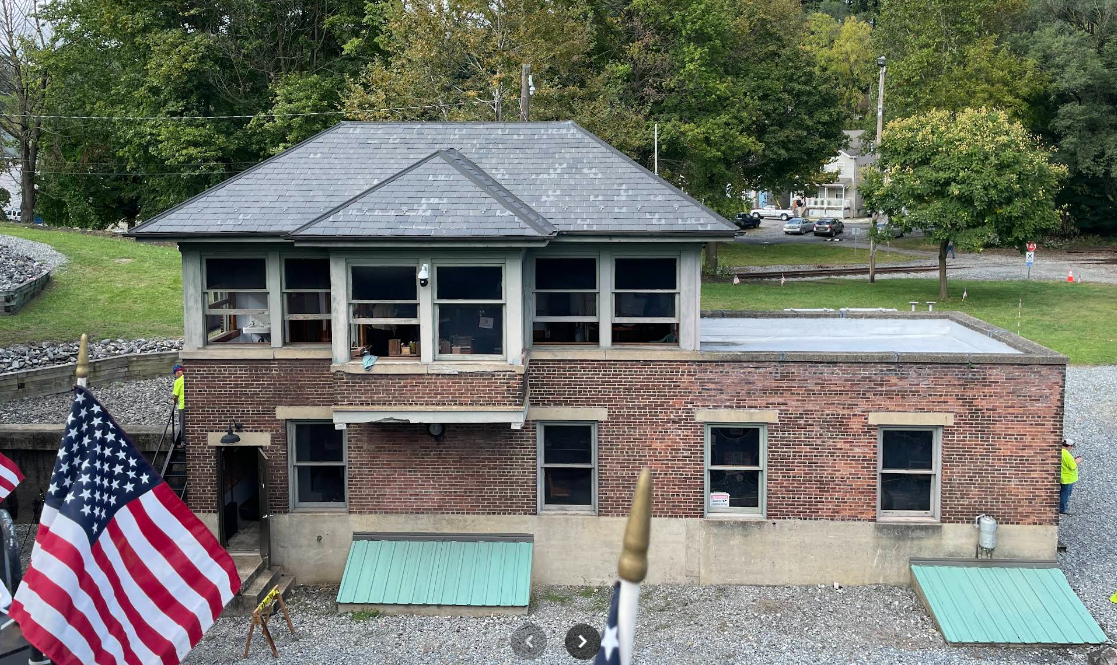
Metrotrails Then and Now Series: Historic 1951 view of the Port Murray train station by Ed Weber, from the Bob Bahrs Collection, compared to the same scene on our 2023 visit.
Port Murray, as the name suggests, started as a canal town on the Morris Canal, but the Morris and Essex Railroad opened in competition with it here in the 1860s. It then became part of the Lackawanna Railroad system in 1868.
The spur around the back was used by the Kenneth Hoppock Coal Company.
The station fell into great disrepair into the 1980s, but then was beautifully restored. While it still could use some work, it is in pretty great shape overall.
There are rumors of its potential demise pending property development. Hopefully it will be saved.
Metrotrails shared
1

2

Mertrotrails posted two photos with the comment:
Then and Now Series: Historic probably 1950s view of the Port Murray train station by Richard H. Young, from the Mike Del Vecchio Collection, compared to the same scene on our 2023 visit.
Port Murray, as the name suggests, started as a canal town on the Morris Canal, but the Morris and Essex Railroad opened in competition with it here in the 1860s. It then became part of the Lackawanna Railroad system in 1868.
The station fell into great disrepair into the 1980s, but then was beautifully restored. While it still could use some work, it is in pretty great shape overall.
Today, rumors are circulating that the station may be in danger of destruction again due to potential development.
Jhon L Garcia shared
1

2

1954/55 Washington Quad @ 24,000

This shows that the dashed blue line in the above map was the Morris Canal.
1894/94 Hackettstown Quad @ 62,500

Tuesday, April 15, 2025

Lancaster, OH: Hocking Canal

(Satellite, Memorial Drive was built on the canal RoW.)

Karla Mendoza posted three images with the comment:
The Hocking Canal in Lancaster, Ohio. Now called Memorial Drive. 1870
Hocking Canal photograph Dated 1876 in Lancaster, Ohio.
A restored 1866 map of Lancaster shows how the canal wound it's way through the city and traces the modern day Memorial Drive route.
The Hocking Canal was abandoned in 1894. In the mid-1930s, the canal bed was filled in and paved over to create U.S. 33 also known as Memorial Drive within the city limits. Now it is just referred to as Memorial Drive or Old 33 as U.S. 33 has now bypassed the downtown corridor. The canal was built between 1829 and 1843. It was 56 miles long and connected to the Ohio and Erie Canal at Carroll, Ohio. The canal was critical for trade, hauling goods like coal and lumber throughout the Hocking River valley. The last canal boat ran in 1889, carrying a load of coal from Logan to Nelsonville. Canals became obsolete with the emergence of railroads. The last canal boat passed through Carroll in 1897.
Lloyd Scott Hardin shared
1

2

3

The oldest topo map I could find still marks the RoW, but as an abandoned canal.
1907/58 Lacaster Quad @ 62,500

Tuesday, March 18, 2025

Washington, NJ: Old Gas Station is still an auto service facility and Morris Canal

Gas Station: (Satellite)
Morris Canal: (Satellite)

I think it is unusual for an old station to have two covered aisles for pumps.
Street View, Aug 2019

Street View, Aug 2019

They look like pumps that compute the total price mechanically. I wonder how he got them to handle the dollar digit in the per gallon price.
Street View, Dec 2021


Metrotrails posted two photos with the comment: "Then and Now Series: Historic postcard image of Eckel's  service station in Washington, New Jersey, compared to the same scene at Guy's service station.
Mr. Eckel reportedly built the station modeled after another service station he had seen in St. Augustine, Florida. The station has been open and very little changed since the 1920s!
Now known as Guy's, Guy Burd and family have operated the beloved step back in time for many years."
Forgotten Railways, Roads & Places shared
1

2

Morris Canal


Metrotrails posted two images with the comment: 
Metrotrails Then and Now Series: Historic postcard view of the Morris Canal passing beneath what is today Belvidere Avenue in Washington, New Jersey, compared to the same scene on our 2023 walk.
The Morris Canal stretched 102 miles from Phillipsburg to Jersey City by 1842, and was a major means of transportation for over twenty years before the first railroad crossed Warren County.
The canal remained in service until 1924, and it was much abandoned by 1927. 
West of Belvidere Ave, the canal prism and towpath are both recognizable, although badly overgrown heading onto the JCP&L property. To the east, the canal is filled in through what used to be Warren Lumber.
Metrotrails shared with the comment: "The Morris Canal in Washington NJ."
1

2

To confirm that I found the correct location. This view agrees with the second image above.
Street View, Aug 2024

1954/55 Washington Quad @ 62,500

Saturday, April 20, 2024

Portage, WI: Milwaukee Depot, Junction Tower & Railyard and Portage Canal

Extant Depot: (Satellite)
Junction: (Satellite)
Railyard: (Satellite)
Canal: (Satellite)

I remember Portage, WI, because it has the one-mile canal that connected the Wisconsin River with the Fox River and helped create the Wisconsin Waterway.

Street View, Jul 2018

CPCK must still use the depot as an office because there is an Amshack just west of the depot.
Street View, Jul 2018

The railyard is still quite active. I saw at least a couple of locomotives parked there and some MoW equipment as well as some cuts of freight cars.
Satellite

John Harker posted two images with the comment: "Bob Crisp photographed this trio of Milw GP38-2s on a freight passing the Portage Junction, Wisconsin tower east of the Portage yard and depot on June 23, 1982.  GP38-2 353 was part of the first order, 350 to 355, that entered service in June 1973.  A total of 16 units were purchased by the Milw for secondary and branch line service.  An aerial map is included for reference.  John Harker photo editing and collection."
Scott Janz: The middle loco is crossing the Portage canal, a link of the Fox River and Wisconsin River. The tower controlled a lift span that once was there as well as the M&P junction just past the bridge and other things. The tower made it to the early 90’s, although abandoned at that time.
1

2

193 aerial photo

The Milwaukee route to the east is now abandoned. The north/south route became part of the Wisconsin Central. The north part is now abandoned, and the south part became part of Milwaukee.
1902 Portage via Dennis DeBruler

Trent Briggs posted
Early Portage, Wisconsin Depot
Glenn Gierzycki: Division headquarters
[I do wish someone would have indicated which railroad used this.]

Arifur Rahman posted
Workers digging the Portage Canal Lock in the late 19th-century. The Portage Canal connected the Fox River with the Wisconsin River at the City of Portage, Wisconsin.


Sunday, April 2, 2023

Phillipsburg, NJ: Preserved/Union Station: CNJ+DL&W, CNJ (PU) Tower, Andover Ironworks and Roundhouses

Depot: (Satellite)
PU Tower: (Satellite)
Ironworks: (Satellite, by 1953, it was a Pensy railyard. Now it is a parking lot.)

Phillipsburg was the western terminus of the Morris Canal.

This Union Station is being restored as a museum. [friendsnjhc]

Street level view:
Street View, Nov 2021

Track level view:
Street View, Aug 2016

R. Donald Winship Photography posted
Green and Gold
Phillipsburg, NJ

The recently repainted NS Reading Lines heritage unit leads NS train 22X past Phillipsburg Union station along CNJ's alignment. There is a *loose* relevance between subject and location -- the B&O controlled the CNJ via the Reading.

J.B. Rail Photog shared

Al Tilltston posted
Norfolk Southern AC44C6M 4001 leads 6K4 east past the Phillipsburg NJ Union Station on Sunday morning June 29, 2025.

Thomas Dorman posted nine photos with the comment: "Union Station (Central Railroad of New Jersey and Delaware, Lackawanna & Western) built in 1914 in Phillipsburg, New Jersey, designed by Frank J. Nies, architect of the DL&W. On South Main Street near Hudson Street. 10 May 2025"
1

2

3

4

5

6

7

8

9

I had to include a lot of the topo map in order to capture the railroad names. The tracks that went along the north side of the station were the DL&W and those that went south of the station were the Central Railroad of New Jersey. Norfolk Southern now has the routes that still exist.
1953 Easton Quad @ 24,000

Just a couple of blocks west of this station is the Delaware River Railroad Excursions.
877trainride
[They offer several different types of train rides. But, like other tourist railroads, their web site doesn't have a map showing where the trains go.]
.

CNJ "PU" Tower


E. Miller, Sep 2023

Al Tillotson posted
Central RR of New Jersey PU tower, Phillipsburg NJ, Wednesday morning March 20, 2019.

Marc Lipkin, Sep 2023

E. Miller, Sep 2023
.

Lost/Andover Ironworks/Cooper-Hewitt Works

Metrotrails posted two photos with the comment:
Metrotrails Then and Now Series: Historic Phillipsburg, New Jersey scene on the slopes near Delaware Heights along the Delaware River, looking toward the Andover Ironworks, compared to the same scene on our 2020 hike.
Previously known as the Cooper-Hewitt Works, the operation dominated the Delaware Riverfront in Phillipsburg at the turn of the twentieth century.
Here, we see the Belvidere-Delaware Railroad (Pennsylvania Railroad) approaching the furnace, which is now a popular excursion line. It crosses over the Lopatcong Creek just prior to the furnace. The Morris Canal passed along the east side of the furnace, present site of the Andover Morris Elementary School...
Metrotrails shared
1

2

The trees made it hard to find the Lapatcong Creek. Fortunately, Google labels it if I zoom in close enough. I could not find the school.
Satellite

An older topo shows the canal.
1891 Eaton Quad @ 62,500

Roundhouses


Phil Craig posted
Map of Phillipsburg NJ. Over the years they had at least 7 or 8 [roundhouses]. Not sure how many can still be located.
William L. Vanderburg: You can see at least 3 from google earth. The one north of the center river crossing is where the steam train ride is now. That train ride actually passes the land area where the rh at the bottom of the map is located. But if you didn’t know it was there, it wouldn’t mean anything to you.

Tim Starr posted
Phillipsburg NJ had six roundhouses within a few blocks of each other in 1900. At the top is the Belvidere and Delaware, 8 stalls, gone a few years later. The two next to each other are Central of New Jersey (16 stalls and 19 stalls, built in 1865). The rectangle shaped one at right is Morris and Essex (later DL&W). The one at bottom left is the Pennsylvania RR, 12 stalls. There was even another 3-stall roundhouse just west of here (not on the map) by the Lehigh and Hudson River.
John Sanheim: Looks like when this drawing was made the two roundhouses were no longer in use as the turntable and housing tracks are gone. Some old roundhouses were re purposed after steam and used as other types of shops. Those two have no track access.

Tim Starr commented on John's comment
They were still active. The artist just didn't draw the TT or tracks.