Roundhouse: (
Satellite)
Depot: (
Satellite)
Allen R. Quig commented on a
post: "Do you have any pictures of the old round house in Oxford?"
Gary Schroeder replied with two images:
 |
| 1 |
 |
| 2 |
The roundhouse footprint is still visible.
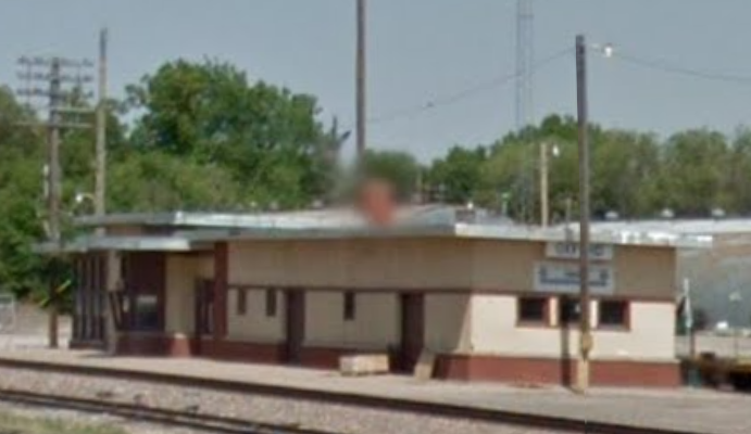
Thanks to the first image above, I know this was the depot.
Gary Schroeder
posted eight photos with the comment:
Today, September 7, 1962, I went to work at the Chicago Burlington & Quincy depot in Oxford, Nebraska..
The hours were 8pm to 5am with Tuesday and Wednesday off . The rate of pay was $17.32 per day for eight hours..
The big doors on the South side of the depot were the entrance of the baggage room and still the same doors.
Retired 45 years and 51 days later in October 2007..
Some changes were made in the waiting room located in the West end of the building but the rest of the building is the very close to the way it was sixty three years ago.
Alice Weatherwax: I always loved going to the depot to see my dad. And I thought I had a really good voice so I would go out in the waiting room and I would dance and I was saying cause it echoed and I thought that was pretty cool ! And the way back I would climb up on the green carts with the red handles and dance up there. Then there will be times when there would be a cream can't explode the top off and it would smell like sour cream. it was horrible and yes, I remember going to the ice Cappas. We had so much fun. Also, mom would take us Gerald and I to Holdridge a lot on the zipper and we could spend our allowance and then we would ride the zephyr back home and that was exciting. I would always spend my money on a doll that had the longest hair and then I would go home and cut it off. Then I went to the real deal and cut Kathy Spangrud's long curls off , they went to her butt, but not when I got done, boy was her mom mad! I should've known way back then I was going to be a hairdresser for 50 some years.
Thanks so much for sharing Gary. You brought back a lot of memories for me. !
Clyde Davis: What Dispatchers did you work with?
Gary Schroeder: Little history first. I was drafted into the Army in May 1965 and discharged May 1967.
When I was at depot in Oxford Fred Putman was afternoon dispatcher and Leonard Bath was midnight dispatcher.. The midnight Chief was probably your dad Jerry Davis..
When I got out of the Army in 1967 I bumped in call office at McCook. I worked Saturday and Sunday during the day and the Esst dispatch was Wayne Thomson and West Dispatcher was Don Kennedy and day Chief was Gene Bush. Monday was 4pm to midnight. Fred Putman was on the East end and Jim Riestein (sp) on West end.. The afternoon Chief I can’t remember. Tuesday and Wednesday I worked midnight to 8am. Leonard Bath on East end and Jerry Davis West end.. The night Chief was Chuck Bush..Vern Nylander, Ray Thomas, Ray Rose,Gene Bush were relief dispatchers protecting rest days. Extra board was Marv Potthoff from the relay office. The Chief dispatcher was Mel Miller who passed in October 1969 and Wayne Thomson became chief dispatcher then..
I went into train service in August 1969 . I had seven years of seniority as a clerk when cuts were made upstairs in the main office and I couldn’t hold a job in McCook.. John Pohl the train master talked me into going into train service where I finished my time on the railroad. End of story.
 |
| 1 |
 |
| 2 |
 |
| 3 |
 |
| 4 |
 |
| 5, cropped |
 |
| 6 |
 |
| 7 |
 |
| 8 |
Oxford is on the BNSF/CB&Q mainline between Chicago and Denver.
The topo map accurately marks the location of the roundhouse and depot.
 |
| 1959 Hollinger and 1960 Oxford Quads @ 24,000 |