Showing posts with label canalME. Show all posts

Sunday, May 18, 2025

Cincinnati, OH: Miami & Erie Canal Mitchell Avenue Aqueduct over Mill Creek

(Satellite, see topo map below.)

Miami & Erie Canal Overview

Kamena Jisanaa posted
Fascinating Miami-Erie Canal History...
In the early 19th century, the opening of the Miami-Erie Canal in southwestern Ohio was an event of great importance to the City of Cincinnati, as well as to the settlements northward through the Mill Creek Valley, in particular Cumminsville five miles north of the Ohio River.  
The canal was chartered in 1824 and   construction began in July, 1825 at Middletown with grand ceremonies.  DeWitt Clinton, of New York, then regarded by some as the greatest living American statesman and the "father of canals," delivered the address.  The section from Middletown to Cincinnati was completed in 1827, with Ephraim Knowlton supervising the digging of the mile through Ludlow Station/ Cumminsville (roughly a little south of the current Ludlow Viaduct to across from the entrance to Spring Grove Cemetery)  Knowlton was later memorialized in Cumminsville with the naming of Knowlton's Corner, where he operated a general store, and Knowlton Street.  In May of 1827 two boats passed near what became Clifton Ave, six miles north of Cincinnati, amid the enthusiastic cheers of sightseers and passengers. Subsequently, when further completed to Dayton in 1828, the event was celebrated by elaborate ceremonies and festivities. The first boat operating locally was the "Hannibal of Carthage," owned by Ephraim and Sidney Knowlton. The great waterway relieved the drudgery of transport by muddy roads and was of incalculable benefit to the people, facilitating commerce and raising the value of adjacent lands...  Such was the excitement in early days that there were "canal-boat parties" organized, similar to "trolley parties" of the early 20th century.  Following is a photo of the canal "aqueduct" about the present location of Mitchell Ave...
Lloyd Scott Hardin shared

Dennis DeBruler commented on Lloyd's share
The canal used to go along the south edge of the Mill Creek Valley. A lot of dirt has been moved since this 1914 map was drawn.
- Mitchell Ave. was straightened and widened, filling in the little creek that drained into Mill Creek. This little creek is the one that the aqueduct crossed.
- The topo map erroneously draws a straight line across the little creek.
- Mill Creek itself has been channelized.
- The Vine Street Hill Cemetery has grown down the hill filling in more of the canal.
- I-75 was built along the south edge of the Mill Creek Valley.
So this is my best guess as to the location of the aqueduct: https://maps.app.goo.gl/sDFeQkspcxgQ1Maf9.
Topo map: 1914/14 West Cincinnati Quad @ 62,500

Seraphina Daphne posted three images with the comment: "Mitchell Avenue Aqueduct! Historic photo of a wooden aqueduct  over Mitchell Avenue on the Miami & Erie Canal, looking northeast towards St. Johns German Catholic Cemetery. The original stone tunnel under the canal collapsed in roughly 1890, and this aqueduct was built while a more permanent span was designed and constructed. It wasn't until 1897 that the contract was awarded to the King Bridge Company. The towpath bridge was supposedly upgraded to steel in 1902 to support the weight of the electric mule locomotives."
1

2

3

River Kelly added this image to the images and descriptions in Seraphina's post above


I wrote these notes in the main blog before I discovered that I wrote about the aqueduct in this blog.

(Satellite, urbanization has moved Mill Creek and removed the tributary. I-75 is built over the canal's land.)

This area of the M&E Canal seems familiar, but I can't find any existing notes about it.
(Update: these were the notes.)

Ron Zig commented on a post
[St. John Cemetery]

The aqueduct was north of this intersection.
1914/14 West Cincinnati Quad @ 62,500

Wednesday, May 14, 2025

Spencerville, OH: Event Space/Erie Depot, Wood Grain Elevator and M&E Canal Lock #16

Depot: (Satellite)
Elevator: (Satellite)
Lock #16: (Satellite)

Note the wood grain elevator behind the right side of the depot.
Street View, Oct 2024

Allen County Museum and Historical Society posted
This week's #ThrowbackThursday features Locomotive #3024 at the Erie Depot, eastbound of Spencerville, Ohio in 1941.

The elevator also has a couple of stave silos.
360-photo May 2020

With all those small bins in the bottom center, I wondered if this is a feed mill. Note the switcher in the upper-right corner. Some of the industries in this town get rail service.
Satellite

This feed truck on the scale confirms that this is a feed mill.
360-photo May 2020

Here is one of their feed trucks making a delivery.
UnitedEquityInc

As is typical, rail service in a small town is being supplied by a shortline.
Street View, Jul 2023

Note the Miami & Erie Canal marked on this map.
1944/44 Spencerville Quad @ 62,500

The canal is extant.
Street View, Jun 2023

In fact, there is still remnants of a lock on the south side of town.
Street View, Jun 2023

It was Lock #16.
vanwert via Dennis DeBruler

Saturday, April 19, 2025

Cincinnati, OH: Miami & Erie Canal

(Satellite, It followed Central Parkway into town and turned East here. Going east is the stretch in the photo below.)

According to the topo map below, the canal turned South a half-block east of Sycamore Street and terminated three blocks later. I'm surprised that it did not go down to the Ohio River. (Update: it did go to  the river. See the newer posts below. It looks like the canal south of Central Parkway on the topo map was an industrial spur. The main canal followed today's Eggleston Ave. route and ended in Sawyer Point Park. I wonder how many locks were needed to descend to the river.)


Cincinnati has a lot of photos of the canal through Cincinnati.


Roads Traveled Through Time posted
The Miami and Erie Canal in Cincinnati, Ohio looking east with Mount Adams in the distance.  
abt 1905

1914/14 West Cincinnati Quad @ 62,500

Update: the canal did end at the Ohio River.
Ronda M Mathias posted
Ohio River Levee
The Ohio River circa 1904. "Along the levee, Cincinnati."
Doug Manson: Miami Erie Canal ended where Sawyer Point is now.
Lloyd Scott Hardin shared

Jefe Neeban posted three images with the comment:
**The 274-mile "Miami-Erie Canal", constructed from 1825-1845 at a cost of $3.28 million, connected the Ohio River at Cincinnati with Lake Erie at Toledo.  **
Ohio's total canal system, including the "Ohio-Erie Canal", cost approx. $8 million, equivalent to $273 million today!...** **
Canals served as the "railroad" and "interstate highway" of the early 19th Century, replacing horse & wagon for the long distant transportation of manufactured and consumer goods.  However, less than a decade after the completion of the Miami-Erie Canal,  railroads began to be built throughout Ohio and across the entire country, greatly reducing the usefulness of canals for their intended purpose.  As a result, the Miami-Erie Canal soon saw a gradual decline in use, making it a ready swimming pool and playground for children, and eventually an open sewer for the Cincinnati neighborhoods through which it ran. 
Following is an aerial drawing of Cincinnati on the Ohio River showing the route of the Miami-Erie Canal through the city; a colorized photo of the canal through Cincinnati's historic "Over the Rhine" neighborhood; and a map of Downtown Cincinnati showing the names of the 20th century streets that were once a waterway...
[Some comments mention towns in which you can still see remnants of the canal. Update: I don't know what the "posted" link now goes to a different post. Bummer. I would have copied some of the comments if I knew Facebook would screw up the link.]
Allie Sherlo posted the same comment and images. [That is when I discovered that Jeff's link is broke.]
Love Ohio posted a plagiarism of Jeff's photos and description.
Cragnolini M Line also plagiarized Jeff's work.
1
Jeffrey Molton: I have an old 6' long blueprint of the Ohio-Erie canal improvements from 1909. It shows in plan and profile, all of the locks, recharge locations(lake names), elevations, and other neat information about the canal.

2

3
Jefe Neeban posted
How much do you know about canals?  What about the Cincinnati subway?  You probably know something, but if you'd like to take a deeper dive, check out the updates I posted to my transit website.  It includes an extensive history of the Miami & Erie Canal, the Warren County Canal, the Cincinnati subway, the Whitewater Canal, and the Cincinnati & Whitewater Canal.  Updates and links at the top of the homepage.  
Lloyd Scott Hardin shared

Life Is Ohio posted
The Miami and Erie Canal began in 1825 as a way to connect the Great Lakes to Cincinnati, and a section of the canal passed right through downtown. Over the following decades, boats transported a number of goods along the waterway, allowing for small towns to come back to life and many businesses to take advantage of this new method of transportation in the area.
Lloyd Scott Hardin shared

Whinke posted
An older now vs then: The Miami and Erie Canal through Cincinnati OH, USA. Pre-1928 vs post-1928

6:31 video

Eloise Lillian posted
If anyone can tell me anything about this picture that would be great. I can’t find anything on it other than it’s Cincinnati
Thank you to everyone who commented on this photo! Loved to read what everyone knows!
Dale Ashcraft: miami erie canal running through cincinnati. central parkway area heading north. not an expert but google it, they have maps and everything. [It would have been nice if he provided the search string.]

The bend was a little south of Hopple Street and in the east side of today's railyard.
1914/14 West Cincinnati Quad @ 62,500

Sunday, April 18, 2021

Delphos, OH: Junction: CFER/Pennsy vs. Aban/.../NKP/Cloverleaf

(Satellite)

CFER = Chicago, Fort Wayne & Eastern

Pam Wannemacher posted
Delphos crossing pennsy
Christopher Allen Howe: That's the Pennsy depot on the left and you can barely make out the bay window of the tower next to it by the train.
[The tower was razed in 1985. The tower was in the northwest quadrant of the crossing.]

The multiple east/west tracks are CFER/Pennsy. The rest was NKP/Cloverleaf, but the spoke going South was just an industrial spur. Most of the NKP is gone. I presume what is left is switched by the CFER.
1960 Delphos Quadrangle @ 1:24,000

Pam Wannemacher posted, cropped
Delphos RR tower at PRR/NKP diamond. Top photo taken in 1935, middle photo in mid 50’s, bottom 1976. Notice how tower losing windows through the years.

Jeff Rich posted, cropped
Aerial view of the PRR/NKP Interlocking in Delphos, Ohio Looking South/Southwest with former Cloverleaf buildings and trackage visible including the highly restricted curve as the track looks toward Landeck.

Dennis DeBruler commented on Jeff's post
You can also see the Miami & Erie Canal that went north/south through town.
Jeff Rich: Yes, this little town had it all. PRR Fort Wayne mainline where T1s and the turbine ran, the Nickle Plate, the AC&Y, Ohio Electric Interurban, the Miami & Erie Canal and the Lincoln Highway.
http://www.delphos-ohio.com/Holdg.../interurban_railroad.htm

Matthew Ditton posted
This one is at Delphos, Ohio where the Pennsylvania and Nickel Plate Railroads crossed at one time. The before shot was taken in March of 1983 by Bill Haines of a southbound N&W local crossing the former Pennsy and with the tower still standing. The former NKP tracks this train was on would be removed in 1998 and the former Pennsy is now the Chicago, Fort Wayne and Eastern Railroad . I took the current shot on 4/2/2023 and there are short sections of rail still leading up to the former diamond on both sides. I'm not sure what year the tower was razed but hopefully someone on here will know.
Tim Shanahan shared
Ken Miller commented on Matthew's post
The Southbound signal still stands and is lit up.

The railroad siding is now a driveway for trucks.
Street View, Oct 2016

And turning about 180 degrees I found another elevator isolated by the railroad.
Street View

Thursday, February 11, 2021

Franklin, OH: Four Modes of Transportation


Charlie Easton posted
This is a very old photo taken near my home town of Franklin, OH. The track would be, I believe, Big 4. Next to it is interurban track. Next is a road and then a canal.
I just thought the juxtaposition was neat. Sorry it's not better but it's well over 100 years old.
Jim Thompson: It is the Miami Erie Canal. Just south of there about 5 miles are the Excello Locks.
Charlie Easton: My father tells of taking sacks of grain to market. After the feed store weighed them they would take them to the bridge over the canal and drop them into the canal boat. This would be about 2 miles north of what I believe this spot to be. The canal in Franklin was filled in and became Canal Street as I was told. The old Big Four tracks, only a siding in my lifetime were right next to canal Street there.

Dennis DeBruler commented on Charlie's post
Actually, I think the order from left to right is the Cincinnati, Dayton & Toledo Electric, road, canal and Big Four. Note that we can see a passenger train on the right up on the bluff. One reason I concluded that this is the order is that the canal was always between the CD&T and Big Four in the area of Franklin. I think the photo was in this stretch but that Riviera Drive had been moved from south of the Big Four to between the canal and the CD&T.
1908 Miamisburg Quadrangle @ 1:62,500

Dennis DeBruler commented on Charlie's post
OH-73 now uses the RoWs of the canal and Big Four between Twin Creek and the bend in the Miami River.

Monday, February 8, 2021

Hamilton, OH: Miami & Erie Canal and OH-4 Bypass

(Satellite, OH-4 used to be the Miami & Erie Canal route.)

Facebook Reel

Butch Stone posted two photos with the comment: "Miami and Erie Canal In Hamilton Ohio."
The Ohio & Erie Canal was on the east side of the state. This would have been the Miami & Erie Canal.
What is the name of the street and railroad?
I believe this is the PRR crossing over St Rt 4 in Hamilton and in the satellite view you can see the shadow of the bridge.
1

2

Dennis DeBruler commented on Butch's post
I noticed that Google Maps called it OH-4 Bypass. They obviously built that bypass in the canals' RoW through town.
1915 Hamilton Quadrangle @ 1:62,500

Dennis DeBruler commented on Butch's post
When I noticed that the canal paralleled the East Middletown Branch of the CH&D, I fired up the Aban RR Map to follow that route. But that route is missing.

Dennis DeBruler commented on Butch's post
Looking at 1955 maps explains why. The abandoned route is just a short segment between downtown and a cutoff that B&O built to a new yard near New Miami.
1955 Hamilton and Trenton Quadrangles @ 1:24,000
Canal Road and the Great Miami River Recreational Trail mark most of the old canal route to the northeast.


Wednesday, March 6, 2019

New Haven, IN: Wabash & Erie Canal Lock #2

(HAER (63 photos) via in0341; HAER photo list; Satellite, evidently the south lanes of US-24 were built over the canal. According to some of the photos, it was located just east of where the ramp now joins US-24.)

Starting on Page 8 of the data file is a general history of the canal.

Tracy Seaman posted
canal locks they found where they were digging for 469?
Tracy Seaman Yep straight white oak and they didnt even remove the bark on ta lot of the trees.
Judy Herendeen They are now in Indy in the historical museum.
Nancy Parker Some of it,not as much as they took. Some was given to Wabash Historical society,some are reburied and some are going to be sliced to sell at Canal days and for display at NH Community Center.
[3. View from above the pool looking west from the east gate to the west gate of the lock, showing the collapsed lock gate at the east end, the breast walls and the double row of lock floor decking. - Wabash & Erie Canal, Lock No. 2, 8 miles east of Fort Wayne, adjacent to U.S. Route 24, New Haven, Allen County, IN [HAER-photo03]]
-  Significance: Lock No. 2 is an example of a wood lock, many of which once existed along the original line of the Wabash and Erie Canal. More fragile than those supported by dressed stone, locks which were constructed on either the timber frame or crib plan were subject to greater wear, deterioration and rot. Lock No. 2 provides an example of nineteenth century wooden lock technology. Engineered to provide a seven-foot lift, Lock No. 2 was one of three similar locks between Fort Wayne and the Ohio/Indiana state line. It was originally constructed between 1837-43 as a Timber Frame Lock (according to the engineer's report of 1837) and in 1849 it was rebuilt as a Timber Crib Lock, the latter being a sturdier type of wood lock construction. At least one additional major repair and/or reconstruction occurred. Lock No. 2 is locally known by the name of its former lockkeeper, Joseph Gronauer and his family. Their farm and store were located adjacent to the lock on the north side, throughout the years of its operation. The family farmhouse remained intact at the site until its demolition between 1942 and 1945. The 20-mile section of the canal within which Lock No. 2 is located, once formed a link between the Fort Wayne-Lafayette portion of the Wabash and Erie Canal to the west and the Miami and Erie Canal in Ohio, to the east. When it was finally completed in 1843, travel and commerce to the Great Lakes and the eastern seaboard, via Toledo, Ohio became possible for the citizens of Indiana. [HAER]


Becky Osbun posted seven photos from the HAER collection with the comment: "On October 3, 1992, an Open House was held at a Wabash & Erie Canal excavation site 8 miles east of Fort Wayne (adjacent to U.S. 24)."
Victoria Kruse This find shut down the construction of US 469 for months as the excavation to salvage these historic pieces of the Wabash and Erie Canal.
Nancy Parker should have kept it delayed longer and made safer exits.
Susan Bonnell Burns Last time I checked these beams were in the Indiana State Museum in Indianapolis.
Gary Keipper Much of the dirt from the lock was removed to a park in New Haven in a fenced in area. My brother and I and some others were allowed to metal detect and sift that dirt. My brother found an old 1700's Mexican or Spanish coin and a clay pipe was found. I believe that all we dug out of there is on display in City Hall n New Haven, although I have never seen it.
Nancy Parker there are also pieces of the lock at the canal museum at Wabash.
John VanHorn Our neighbor's garage attic floor is made with boards salvaged from one of the Gronaurs outbuildings.

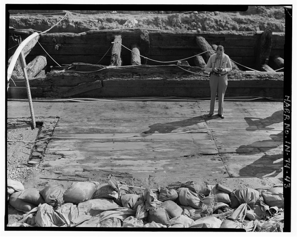
42. Open house at the site, Saturday, October 3, 1992. View north/northwest. Photograph shows the lock support floor joists on sleepers and the mortised crib walls. The 1 inch board at the base of the crib wall is the pre-super construction 'footprint' for alignment.
https://www.loc.gov/pictures/item/in0341.photos.318662p/

Dennis DeBruler 43. A view from the north, looking south across the lock floor. Two layers of floor decking are visible at left, where part of the floor decking, damaged by telephone company intervention, has been removed.
https://www.loc.gov/.../item/in0341.photos.318663p/resource/

Dennis DeBruler 3. View from above the pool looking west from the east gate to the west gate of the lock, showing the collapsed lock gate at the east end, the breast walls and the double row of lock floor decking.
https://www.loc.gov/pictures/item/in0341.photos.318623p/

Dennis DeBruler 45. View along the length of the lock, from the east, looking southwest Oak shooks and carpet protected the resource from visitor traffic. A worker is 'watering down' the lock, to prevent damage from desiccation.
https://www.loc.gov/pictures/item/in0341.photos.318665p/

Dennis DeBruler 44. View looking northeast. The lock was emptied of guests periodically during the day so that the timbers could be sprayed down with water. The board walk was laid over the west miter sill (at center) to allow visitors to enter without damaging the sill.
https://www.loc.gov/pictures/item/in0341.photos.318664p/

Tommy Lee Fitzwater posted
Wabash & Erie Canal,New Haven,Allen County,Indiana,IN,Historic Survey,HABS,43


Dennis DeBruler 46. View looking west, toward west gate. Planks were laid in the mud (center left) so that visitors could view the inside of the south, forebay crib and examine the unusual right-handed counter foil. A visiting engineer perceived this as quite 'modern'.
https://www.loc.gov/pictures/item/in0341.photos.318666p/

Dennis DeBruler 60. Same view, showing technicians hosing down the timbers. Shortly after this photograph was made, the timbers were completely submerged in water, held down by heavy concrete castings.
https://www.loc.gov/pictures/item/in0341.photos.318680p/

Randy Harter commented on Becky's post

Drawing from HAER IND,2-NEHA.V,1- (sheet 1 of 4) from in0341

Drawing from HAER IND,2-NEHA.V,1- (sheet 2 of 4) from in0341

Drawing from HAER IND,2-NEHA.V,1- (sheet 3 of 4) from in0341

Drawing from HAER IND,2-NEHA.V,1- (sheet 4 of 4) from in0341
Rick Stabler posted four photos with the comment:
Lock #2 (Gronauer Lock) from the fabled Wabash & Erie canal east of New Haven. The lock was discovered during Hwy 469 construction in June 1991, it's western gate pictured during excavation. Portions of the lock are now in an Indiana State museum. There were three locks between the Ohio State line and Fort Wayne, which raised the canal 20 feet, giving Fort Wayne the nickname, "Summit City" the highest point along that stretch of the canal. The Joseph Gronauer family farm ran adjacent to the canal and they operated the lock during it's entire 40 year life span (1833-1878). The lock was buried and the Gronauer farm razed in the 1940's during U.S. Highway 24 widening (Hwy 24 runs parallel to the canal east of Fort Wayne and the highway was built right over the canal west I-69 to Huntington). An untouched portion (but now a cat-tail choked ditch) of the Erie canal still exists along Taylor Street between Hazelhurst Drive and Coleman Ave just west of downtown along the old interurban right-of-way (the original tow-path of the canal and marked "Towpath Trail" on maps) in the Eagle Marsh Nature Preserve along the Engle Road.
1

2

3

4