Starting on Page 8 of the data file is a general history of the canal.
 |
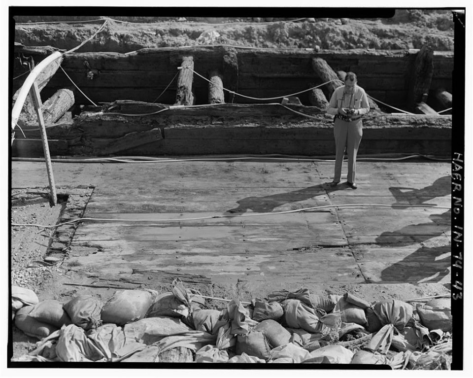
| Tracy Seaman posted canal locks they found where they were digging for 469? Tracy Seaman Yep straight white oak and they didnt even remove the bark on ta lot of the trees. Judy Herendeen They are now in Indy in the historical museum. Nancy Parker Some of it,not as much as they took. Some was given to Wabash Historical society,some are reburied and some are going to be sliced to sell at Canal days and for display at NH Community Center. [3. View from above the pool looking west from the east gate to the west gate of the lock, showing the collapsed lock gate at the east end, the breast walls and the double row of lock floor decking. - Wabash & Erie Canal, Lock No. 2, 8 miles east of Fort Wayne, adjacent to U.S. Route 24, New Haven, Allen County, IN [HAER-photo03]] |
- Significance: Lock No. 2 is an example of a wood lock, many of which once existed along the original line of the Wabash and Erie Canal. More fragile than those supported by dressed stone, locks which were constructed on either the timber frame or crib plan were subject to greater wear, deterioration and rot. Lock No. 2 provides an example of nineteenth century wooden lock technology. Engineered to provide a seven-foot lift, Lock No. 2 was one of three similar locks between Fort Wayne and the Ohio/Indiana state line. It was originally constructed between 1837-43 as a Timber Frame Lock (according to the engineer's report of 1837) and in 1849 it was rebuilt as a Timber Crib Lock, the latter being a sturdier type of wood lock construction. At least one additional major repair and/or reconstruction occurred. Lock No. 2 is locally known by the name of its former lockkeeper, Joseph Gronauer and his family. Their farm and store were located adjacent to the lock on the north side, throughout the years of its operation. The family farmhouse remained intact at the site until its demolition between 1942 and 1945. The 20-mile section of the canal within which Lock No. 2 is located, once formed a link between the Fort Wayne-Lafayette portion of the Wabash and Erie Canal to the west and the Miami and Erie Canal in Ohio, to the east. When it was finally completed in 1843, travel and commerce to the Great Lakes and the eastern seaboard, via Toledo, Ohio became possible for the citizens of Indiana. [HAER]
Becky Osbun posted seven photos from the HAER collection with the comment: "On October 3, 1992, an Open House was held at a Wabash & Erie Canal excavation site 8 miles east of Fort Wayne (adjacent to U.S. 24)."
Victoria Kruse This find shut down the construction of US 469 for months as the excavation to salvage these historic pieces of the Wabash and Erie Canal.
Nancy Parker should have kept it delayed longer and made safer exits.
Susan Bonnell Burns Last time I checked these beams were in the Indiana State Museum in Indianapolis.
Gary Keipper Much of the dirt from the lock was removed to a park in New Haven in a fenced in area. My brother and I and some others were allowed to metal detect and sift that dirt. My brother found an old 1700's Mexican or Spanish coin and a clay pipe was found. I believe that all we dug out of there is on display in City Hall n New Haven, although I have never seen it.
Nancy Parker there are also pieces of the lock at the canal museum at Wabash.
John VanHorn Our neighbor's garage attic floor is made with boards salvaged from one of the Gronaurs outbuildings.
 |
| 42. Open house at the site, Saturday, October 3, 1992. View north/northwest. Photograph shows the lock support floor joists on sleepers and the mortised crib walls. The 1 inch board at the base of the crib wall is the pre-super construction 'footprint' for alignment. https://www.loc.gov/pictures/item/in0341.photos.318662p/ |
 |
| Dennis DeBruler 43. A view from the north, looking south across the lock floor. Two layers of floor decking are visible at left, where part of the floor decking, damaged by telephone company intervention, has been removed. https://www.loc.gov/.../item/in0341.photos.318663p/resource/ |
 |
| Dennis DeBruler 3. View from above the pool looking west from the east gate to the west gate of the lock, showing the collapsed lock gate at the east end, the breast walls and the double row of lock floor decking. https://www.loc.gov/pictures/item/in0341.photos.318623p/ |
 |
| Dennis DeBruler 45. View along the length of the lock, from the east, looking southwest Oak shooks and carpet protected the resource from visitor traffic. A worker is 'watering down' the lock, to prevent damage from desiccation. https://www.loc.gov/pictures/item/in0341.photos.318665p/ |
 |
| Dennis DeBruler 44. View looking northeast. The lock was emptied of guests periodically during the day so that the timbers could be sprayed down with water. The board walk was laid over the west miter sill (at center) to allow visitors to enter without damaging the sill. https://www.loc.gov/pictures/item/in0341.photos.318664p/ Tommy Lee Fitzwater posted Wabash & Erie Canal,New Haven,Allen County,Indiana,IN,Historic Survey,HABS,43  |
 |
| Dennis DeBruler 46. View looking west, toward west gate. Planks were laid in the mud (center left) so that visitors could view the inside of the south, forebay crib and examine the unusual right-handed counter foil. A visiting engineer perceived this as quite 'modern'. https://www.loc.gov/pictures/item/in0341.photos.318666p/ |
 |
| Dennis DeBruler 60. Same view, showing technicians hosing down the timbers. Shortly after this photograph was made, the timbers were completely submerged in water, held down by heavy concrete castings. https://www.loc.gov/pictures/item/in0341.photos.318680p/ |
 |
| Randy Harter commented on Becky's post |
 |
| Drawing from HAER IND,2-NEHA.V,1- (sheet 1 of 4) from in0341 |
 |
| Drawing from HAER IND,2-NEHA.V,1- (sheet 2 of 4) from in0341 |
 |
| Drawing from HAER IND,2-NEHA.V,1- (sheet 3 of 4) from in0341 |
 |
| Drawing from HAER IND,2-NEHA.V,1- (sheet 4 of 4) from in0341 |
Lock #2 (Gronauer Lock) from the fabled Wabash & Erie canal east of New Haven. The lock was discovered during Hwy 469 construction in June 1991, it's western gate pictured during excavation. Portions of the lock are now in an Indiana State museum. There were three locks between the Ohio State line and Fort Wayne, which raised the canal 20 feet, giving Fort Wayne the nickname, "Summit City" the highest point along that stretch of the canal. The Joseph Gronauer family farm ran adjacent to the canal and they operated the lock during it's entire 40 year life span (1833-1878). The lock was buried and the Gronauer farm razed in the 1940's during U.S. Highway 24 widening (Hwy 24 runs parallel to the canal east of Fort Wayne and the highway was built right over the canal west I-69 to Huntington). An untouched portion (but now a cat-tail choked ditch) of the Erie canal still exists along Taylor Street between Hazelhurst Drive and Coleman Ave just west of downtown along the old interurban right-of-way (the original tow-path of the canal and marked "Towpath Trail" on maps) in the Eagle Marsh Nature Preserve along the Engle Road.
 |
| 1 |
 |
| 2 |
 |
| 3 |
 |
| 4 |
No comments:
Post a Comment