Showing posts with label weather. Show all posts

Friday, June 27, 2025

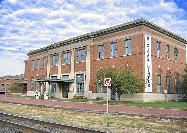
Davenport, IA: 1924 Visitor Center/DRI&NW (Milwaukee+CB&Q) Union Station

(Satellite)

Street View, Jun 2021

Retro Quad Cities posted six photos with the comment:
Davenport Union Station
  DRI&NW
    Built 1924
1

2

3

4

5

6

In the street view at the top, notice that the track is above ground level. During the flood of 2019, CP kept hauling in ballast trains and dumping ballast on the track. Then they used a tamper to lift the track above the ballast. They were in a race to keep the track above the river level. Then they refused to remove all of that ballast after the flood. In fact, I see they put larger rock on top of the ballast to help avoid a flood eroding the ballast.
Street View [Google Maps is giving me a bad link, zoom out and pan down to see the building], Aug 2017

Compare this view with photo 5 above. They have rebuilt Harrison Street to go over the higher track and CP put the signaling equipment on top of a platform.
Street View, Jun 2021

Tuesday, June 24, 2025

Cheyenne, WY: Big Boy 4004 Static Display and Stormwater Problem

(Satellite)

Joss Moni posted
that is at Holiday Park in Cheyenne, WY correct. been there to eat lunch many times
Curt Schnitzer: August 1st 1985.
Bruce Schindler: Curt Schnitzer I remember it well. Massive hail with it.
James Hickey: This is my photograph, used here without my permission from the official UP Steam website. [It is a shame he did not provide the URL of the appropriate webpage.]
James Bowen: Flooding in Cheyenne, how?
Terina Templeton: James Bowen massive rain! My car was all but floating down the street in downtown Cheyenne at about this time period. We had a tornado come through and then torrential rains! Everything was flooded! We lived close to Crow Creek and the water lines in our parked pickup was higher than the wheels. My car was at my sister in laws not far from the hospital and the streets were filled curb to curb plus some. It was like a river running past the houses! Holiday Park Lake was OVER, OVER full and this Big Boy is not far from the edge of the lake. This is really what it looked like. There were lives lost during this flood...
Dave Wallace: Roller bearings can be replaced....but no real need to....just pump them fulla grease.....
[Steam locomotives could go through water that is a lot deeper than the traction motors of a diesel. I've read that as long as the water is below the firebox, it is OK. And it looks like it is at least a foot below the firebox.]
Christopher Steingrube: This was a few years ago. And if memory serves, this big boy was a parts bin for 3985's resto. She's going nowhere, regrettably.
Lee Miles: Christopher Steingrube to the trained eye you can see all the missing parts, some replaced with fakes. Like the compressors behind the pilot.
Sylvester Rodriquez: Isn't Holiday park an old lake bed? That flood was around 1985. There is archive media coverage of that storm on YouTube.

Note that the fence was almost under water in 1985.
John Dillon, Sep 2022

Street View, Dec 2021

The sign on the fence.
John Fwu, May 2022

Tim Tharp, Aug 2024

The Holiday Park may have been designed to be a retention pond. On a satellite image, everything in the depression contour can be cleaned with a good pressure washer and, in the case of the 4004, some grease. I wonder when they filled in the lower lobe of the lake to make land for more parking and courts.
1961/64 Cheyenne North Quad @ 24,000

Saturday, May 17, 2025

Alton, IL: Lost/Chicago, Peoria & St. Louis Depot

(Satellite, on the south part of the park. US-67 used to be tracks.)

Andy Zukowski posted
Chicago, Peoria, and St. Louis Railroad Depot during the flood in Alton, Illinois. 1903
Bill Edrington: Alton Union Depot, used by trains of the Chicago & Alton and the Big Four, is visible in the background on the right side of the picture.

This depot is near the left side and the Union Depot is near the center.
1941 Aerial Photo from ILHAP

It would have been the Bluff Line Depot in this image.
Adam Davis posted

american-rails


Friday, April 18, 2025

Junction, IL: Lost L&N Depot and Floods

Depot: (Satellite, the white stripe west of the building's foundation was part of the platform.)

David Cantrell posted three photos with the comment:
Flooding at Junction, IL.
1st photo - 4/14/2025 by MG Drone Tours, L&N Depot site circled in blue
2nd photo - 1937 flood aerial photo of Junction, L&N Depot indicated in blue
3rd photo - Junction L&N Depot, 1937 flood, taken by HO Turner
David Cantrell shared with the comment: "Flooding at Junction, IL, former location of L&N Depot. B&O shared track to Old Shawneetown with L&N railroad until the final mile where the tracks diverged to their respective depots."
Gregg Wolfersheim: Flooding was always a problem in the spring. It took 4 days in 1983 to move a PARY train from Mill Shoals to Old Shawneetown. Followed the flood crest each day. Flooding also caused problems latter in summer from all the floating items that gathered around every trestle. Then, it was a fire hazzard!
David Cantrell: Gregg Wolfersheim I counted around 100 bridges between Flora and Shawneetown on a B&O track map. It didn't indicate if they were trestles, culverts, or other structures. My grandpa worked that line from 1941 to 1977. I went with him several times to Old Shawneetown to look at the water on his days off. We also used to drive up north of Enfield to see how it was between Springerton and Mill Shoals.
Gregg Wolfersheim: David Cantrell During the last year the Prairie Trunk operated, we had 2 bridge guys working with help from some of the track workers. It was a never ending job trying to keep them safe. Most were open trestle types.
Christopher Bailey: Forgive my ignorance but see these tracks still active? Thanks for sharing!
David Cantrell: Christopher Bailey No, unfortunately. Prairie Trunk bought B&O/CSX line and it went bankrupt early 1980's, rails were removed thereafter. L&N Railroad Shawneetown Branch from McLeansboro also ceased operations later but not sure of the dates. Evansville Western Railway operates the eastbound section of former L&N railroad from Oakawville to Mt. Vernon, IN.
1
[April 2025 Flood   The grain bins made it easy to determine that this view is looking South.]

2

3

This topo map did not mark the location of any of the buildings that were between the tracks and Front Street.
1959/60 Shawneetown Quad @ 24,000

1938 Aerial Photo from ILHAP

I looked for a nearby river on a satellite map to see what was causing the 2025 Junction flooding. But I could not find a nearby river. Is the flood water from the Ohio River or was this local flooding caused by a record-breaking rainfall? The Ohio River was high during the middle of April 2025. But I don't think it was near as high as it got in 1937.
Jim Pearson Photography posted via Dennis DeBruler
CSX Mixed freight X509, a reroute, heads north over the flooded Ohio River at Henderson, Kentucky on April 8th, 2025, on the CSX Henderson Subdivision as it crosses the floodplain heading into Evansville, Indiana.
This area of Kentucky and southern Indiana got record breaking rainfall throughout the region over a three-day period which resulted in major flooding on both sides of the Ohio River. In the distance you can see the farmlands which have been totally covered by the flooding and the ballast deck out of Evansville was close to being covered, but fortunately it didn’t happen.
Tech Info: DJI Mavic 3 Classic Drone, RAW, 22mm, f/2.8, 1/2000, ISO 100.
Curt Finke: Awesome perspective! I'm wondering... since the river crested yesterday (4 days after this photo was taken), do you know whether or not the ballast deck out of Evansville was covered?
Jim Pearson Photography: Curt Finke Thanks! Not that I've heard and trains have been running.

US National Weather Service Ohio River Forecast Center posted
Major flooding persists in the lower portions of the Green, Wabash, and mainstem Ohio Rivers.  These will slowly start to recede as all the water in the lowlands and farm fields of the lower Ohio Valley makes its way to the Mississippi.

Monday, April 14, 2025

Aurora, IN: Museum/B&O Depot

(Satellite)

Street View, Aug 2013

44:34 video @ 34:29

April 2025 Flood:
@ 35:42

It looks like the grain bins are built on thick foundations to keep the bottom of the bins above the flood waters. I wonder what was stored in the foreground.
Street View, Aug 2023

In the left background, we can see where the Ohio River is supposed to be.
@ 35:46

See the George Street and B&O Bridges for more flood scenes.

Friday, February 28, 2025

Oquawka, IL: Lost/CB&Q Depot, Flood Photos and CGB Grain Elevator

Depot: (Satellite, my guess based on the aerial photo. Evidently, Marina Dr. and Front St. were built on the CB&Q RoW.)
CGB: (Satellite)

Trent Briggs posted four photos with the comment: "Oquawka, Illinois."
Richard Fiedler shared
1

2

3

4

1940/40 Oquawka Quad @ 62,500

1941 Aerial Photo from ILHAP

The town now has a levee along the river. I think the depot would have been in this view.
Street View, May 2023

This town was on a branch (twig) between the mainline to Denver and the "Joy Branch."
1902

Wednesday, February 19, 2025

Rives, TN: CN/IC Route threatened by a flood

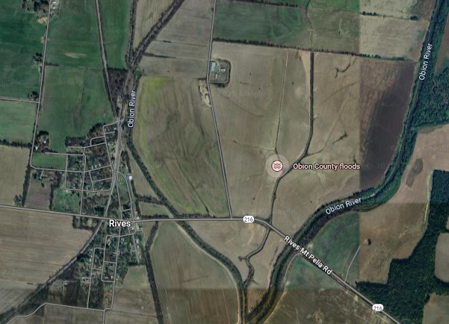
(Satellite, the fields east of town are designed to flood; the town is not supposed to flood.)

2025 TVA Flood: See Pickwick Lock_2025 for information about the weather event.

Feb 16, 2025:
Phil Grant posted that CN's Main Line "has been hit by flooding due to a levee failure at Rives, TN."
Luke Winzenried: There is a speed restriction, but from what I hear trains are still moving. There was also a mudslide in Dyersburg that blocked the tracks.
George Cox: The levee has not broken or failed, flood water started over running the top of the levee at around 5AM this morning.
From the Union City Messenger at about 2:20 PM CST today:
Obion County Emergency Management Agency director Danny Jowers was in the air surveying the serious situation about 1:15 p.m. today (Sunday) when he spoke with The Messenger.
Jowers said water began going over the top of the levee about 5 a.m. today, flooding the tiny town south of Union City off Highway 45 West.
“That’s all it’s doing right now is going over the top,” he said. “It hasn’t broken yet, but we’re flying it right now to see if there’s anything else that’s happening.”
When water begins going over the top of a levee, there is the danger of eating away the levee.
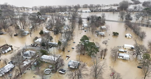
Peyton Smith commented on Phil's post
Water is still rising.

The railroad route that went straight through town was the GM&O.
1951/51 Rives Quad @ 24,000

The GM&O route is abandoned south of town, but we can clearly see the RoW because of the tree line. Note the "Obion County floods" label.
Satellite

I wonder how long that link will be defined. This is what I got on Feb 19 when I clicked the Obion County floods" label.
Satellite

The TEMA link was remarkably uninformative. Buried among generic advice about coping with cold weather, I found a share of this post:
Steve Carr posted the comment:
STATE OF EMERGENCY 
📢 Statement from Obion County Mayor Steve Carr 📢
Dear Residents of Obion County,
Effective immediately, I AM declaring a STATE OF EMERGENCY in response to the severe flooding in Rives and the imminent threats to other low-lying areas within our county (potentially Kenton). This decision has been made to ensure the safety and well-being of our community as we navigate these challenging conditions.
Evacuations: There will be mandatory evacuations in effect for the residents in Rives due to the rising water, no electricity, and freezing temperature creating a life-threatening situation. 
Security: Law enforcement will be actively securing the affected areas to protect residents and property. Please be advised that there will be no trespassing in these zones. Private drones are not allowed as helicopters and public safety drones are in use at this time. We urge everyone to respect this directive, as it is vital for the safety of both our first responders and the community at large.
Public Information: Residents are encouraged to stay informed through official channels, including my social media page, Danny Jowers at EMA, and Sheriff Karl Jackson for updates on the situation and safety instructions.
I encourage all residents in flood-prone areas to remain vigilant and take necessary precautions. Please stay tuned for further updates and follow guidance from local authorities.
Together, let us join our hearts in prayer for all of those affected and we will overcome this situation with His help. Stay safe, and look out for one another.
Sincerely,  
Steve Carr  
Mayor of Obion County
The shelter information was focused on warming shelters.

The "Tipton County Fire Department" link was informative.
Tipton County Fire Department posted
Swiftwater Deployment Update:
The Tipton County Swiftwater Team that was deployed to Obion County this morning has finished their rescue mission and are headed back to Tipton County.

See below concerning "More updates on Google"

Here is Gov. Bill's information:
Gov. Bill Lee posted on X/Twitter

I clicked "More on X," but it wanted me to sign in, and I'm not going to do that on X.

Pursuing the Google Search results.

The distinction between the levee being overtopped instead of breached does not reduce the amount of damage done. But it does provide more time for people to be evacuated. I am surprised that an overtopped levee didn't erode into a breach.
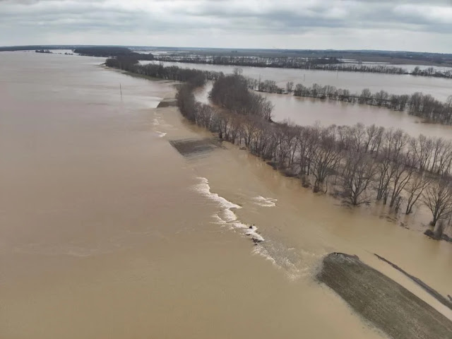
wpsdlocal6, Jasmine Youngblood
The Levee near Rives Mt. Pelia Road.
[Pleasant Hill Road in Rives becomes Mt. Pelia Road a little further east.]

I haven't been able to precisely reconcile the above photo with a satellite map, but I believe that the levee is along the left branch of the Obion River so that the farm fields between the branches of the Obion River can act as a flood plain. The levee around this homestead confirms that the fields are a flood plain. Also, it appears the homestead is just storage. That is, no one lives there.
Street View, May 2024

I think most people would think levee breach rather than levee overtopping when they here "levee failure." But I'm sure Fox News would get more clicks with "failure" than "overtopping." It is a failure in that it was not built high enough to do the job.
fox13memphis, Photo Credit: Lake County Rescue Squad
"State of emergency declared in northwest Tennessee county after levee failure"

In every photo and video that I saw, the top of the CN rails were still above water so the traction motors are safe. But the embankments were soaked above the ties, thus the slow order to go through town. If you look at the above topo map, you can see that the railroad routes are on embankments going far out into the adjacent fields. 

Thursday, October 24, 2024

Asheville, NC: NS Railyard, Yard Tower and Roundhouse

Railyard: (Satellite)
Yard Tower: (Satellite)
Roundhouse: (Satellite)

Daryl Lunsford commented on a post about a NS bridge collapse on Oct 23, 2024
I was a conductor with NS in the 90s, and my cousin still is one. He sent me this drone shot of Asheville yard a couple of weeks ago.
[This is flooding caused by Hurricane Helene.]

This is the yard tower that we see in the water in the above photo.
Street View, Oct 2023

Street View, Feb 2024

None of the topo maps with a scale of 1:24,000 loaded, so I had to use this 1:250,000 map. Southern had routes going to all four points of the compass. They share the route through town so I knew the yard would be along that shared segment.
1960/60 Knoxville Quad @ 250,000

Joseph Anderson posted
Like CSX, NS is not playing around this time and is preparing for future flood events. The replacement housing box for the CP Biltmore interlocking in Asheville, NC I think (at least personally for me) sets a new record for the highest elevated housing box I've seen in all my travels to date. Photo date: 2025-05-18
Jim Ruff: The railroads call these "housing boxes", bungalows.
Jon Roma: Elevated signal bungalows have been a thing for decades; among the installations I recall seeing were on the B&O main line that follows the Potomac River west of Harper's Ferry, and the C&O main line along the Ohio River in eastern Kentucky. The Illinois Central main line along the Mississippi in Kentucky also comes to mind.
Several of these installations were placed after devastating floods in the Thirties. Unfortunately flood events are becoming more widespread.
Joseph Anderson: Jon Roma Out of curiosity, if the components inside the signal housing box are spared from damage from flood events, does that infer that just the switches and their wiring just need to be replaced, or is there more stuff (like the bulbs and wiring for signals that have aspects low to the ground) that would have to be repair/replaced? Or does it simply boil down to "it just depends?".
Jon Roma: Joseph Anderson, when Katrina hit New Orleans in August 2005, Norfolk Southern had already rerouted rail traffic to other inland interchanges with western railroads, and embargoed service to the area where the storm was expected to make landfall. With the railroad out of service, their signal gangs removed as much equipment – switch machines, crossing signals, wayside signals, etc. and moved them to high ground. The railroad simultaneously stockpiled other material like ballast, ties, and rails near but not in the threatened area.
After the storm passed, there was obviously a lot of track damage (including track that was just plain missing) that had to be restored. Meanwhile the signal workforce began to restore the system.
I suspect that, unless the cables were physically damaged or failed insulation testing, the cable ends could be cleaned and reattached. With all the expensive equipment (microcontrollers, switch machines, signals, etc.) out of harm's way, they were able to restore the signal system relatively quickly.
NS produced a video on the recovery from Katrina, and it was quite interesting to watch.
Here's an article in the trade presss about storm recovery in the Thirties, digitized and on my website.
https://tinyurl.com/ymw4skmn