Showing posts with label rfTutajJr. Show all posts

Thursday, August 25, 2022

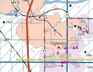
La Salle C: Oglesby, IL: Oglesby Coal Co. Mine

(Satellite)

Roger Kujawa posted
OGLESBY Illinois Coal Mine and Portland Cement Works col. PPC 1924

Dennis DeBruler commented on Roger's post

Dennis DeBruler commented on Roger's post

Dennis DeBruler commented on Roger's post
I think the cement works in the photo was over by Lehigh Ave and todays Lehigh Portland Cement Company was built on the coal mine's land.
1939 aerial photo

Dennis DeBruler commented on Roger's post
It appears the mine was served by Milwaukee and CB&Q. In fact, Milwaukee's branch terminated at the mine. Did Illinois Central also serve it since it went right by it?
1947 La Salle Quad @ 62,500

Roger Commented on his post, full resolution
Christie Pasieka posted this map in: https://www.facebook.com/groups/173510456055053/permalink/8283591945046823/

Ray's LaSalle County Online Museum

Roger Kujawa posted
Postcard Oglesby Illinois - Top Works, Oglesby Coal Shaft seen on ebay
Gary Gray: Can’t really tell where the hoist is located, no visible sheave wheels. Back in those days the hoist was steam powered as indicated by the billowing black smoke stacks. This is located in northern Illinois at the edge of the Illinois coal basin so depth can’t be more than 200 feet from surface to the coal bed, probably a lot less. They are loading gondolas, called gons, on three tracks. Don’t see where the empties are coming from. Would guess that each track represents a separate size consist. Interesting photo. A lot of history presented and a lot missing.
Roger Kujawa: Some more info. The top works may be on the Milwaukee Road and the other part on the Illinois Central RR.
http://www.illinoisarchaeology.com/.../Illinois%20Zinc...

Roger Kujawa commented on his post

Roger Kujawa commented on his post

Christie Pasieka posted
Oglesby Coal Company Mine and the LaSalle Carbon Coal Company Mine No.1.  These pre-dated the Deer Park MIne by a generation. 
These two mines provided the early industrial base around which the present-day community of Oglesby coalesced.

Sunday, July 3, 2022

La Salle C: La Salle, IL: LaSalle County Carbon Coal Mines #1 and #2 (Rockwell)

Mine #1: (Satellite, this was the office. The rest of it is gone)
Mine #2: (Satellite, according to the map below, it was in the northeast quadrant of the interstate and canal crossing.)

Roger Kujawa posted
M.L. RPPC Carbon Coal Company At LaSalle, Illinois. LaSalle County
Glenn G: Yard is gone, aux building is gone. So much history in this shot.
Steven Holding: Deceived Coal to the IC, RI, CB&Q via overhead conveyor to the siding south of the river and the same conveyor hauled the gob to the south side of river. Also dumped into the I&M Canal.
Also, Ray's LaSalle County Online Museum
Photo taken from ICRR bridge

Christie Pasieka posted
Image of the Canal, the Rock Island and the LaSalle Shaft.  In the background before the bend 
in the river, the steamboat basin?
Mike Sabatini: That image shows the mine shaft of the LaSalle County Carbon Coal Company at the south end of Union St. The mine office still stands and has been converted to a residence. The sunken barge in the foreground is east of there. Lock 14 is toward the west.

Bill Holding commented on Roger's post
Office still there Corner of Union and !st St.

Street View

Directory

Map

I think the photo was taken from the IC bridge. But I find it hard to believe that there was that much industrial activity west of the bridge.  An old topo map confirms that there was residential development along  the river bluff even back then.
1913 La Salle Quad @ 1:24,000

1939 Aerial Photo from ILHAP

Roger Kujawa posted
Here is a neat postcard of LaSalle. I would say this is east of town and that's the Rock Island Track next to the canal. The IC bridge is either behind the photographer or way off in the distance. Any thoughts?

It is always interesting to see how different artists colorize a postcard. Or is this a study of how the colors fade differently in historical postcards?
Ray's LaSalle County Online Museum
Photo taken from ICRR bridge looking West.
Remnants of mine still visible on side of the hill in late fall/winter

Ray's LaSalle County Online Museum

Ray's LaSalle County Online Museum
LaSalle Shaft March 1901 looking west.
I&M canal at left. Mine dump/slag still piled up on south side of canal.

Andy Zukowski posted eight photos with the comment: "Photos of the LaSalle County Carbon Coal Mine in LaSalle Illinois."
1

2

3

4
No.1 Mine 1926

5

6

7
Supports where the bridge went across the canal to the south side to dump mine slag.

8
Entrance to the Mine
.

Mine #2


Directory

Andy Zukowski posted
Rockwell Coal Mine in LaSalle, Illinois. Looking Northwest in the year 1900
Rj Harmon: Was this the one along the I and M Canal down from Lock 14?

Dennis DeBruler commented on Rj's comment
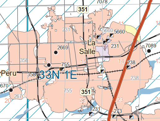
This was Mine #2, and it has index 238. Mine #1 has index 3, and it is closer to Lock #14.

I used the transparency feature of the topo map viewer so that we can see both the 1913 map and today's interstate. This shows that the mine was a little east of the top of the curve in the river.
1913/13 La Salle Quad @ 62,500 plus I-39

The coal mine closed in 1912 so there doesn't seem to be much left in 1939. The quarry for the cement factory now dominates the area.
1939 Aerial Photo from ILHAP