Showing posts with label abanWabash. Show all posts

Thursday, October 3, 2024

Litchfield, IL: North Litchfield Tower: IC vs. Wabash

(Satellite, an abandoned overpass indicates where the IC route used to go north. The road used to be Route 66.)

US-66 Overview

Andy Zukowski posted
Illinois Central Railroad 4-8-2 #2528 South at Wabash Crossing in North Litchfield, IL - October 27, 1946.    Photo by George Drake Sr.
Jacob Hortenstine shared

1944/65 Mount Olive Quad @ 62,500

1938 Aerial Photo from ILHAP

This former-IC overpass over the former-Route 66 is now a bridge to nowhere.
Street View, Jun 2024

Friday, August 23, 2024

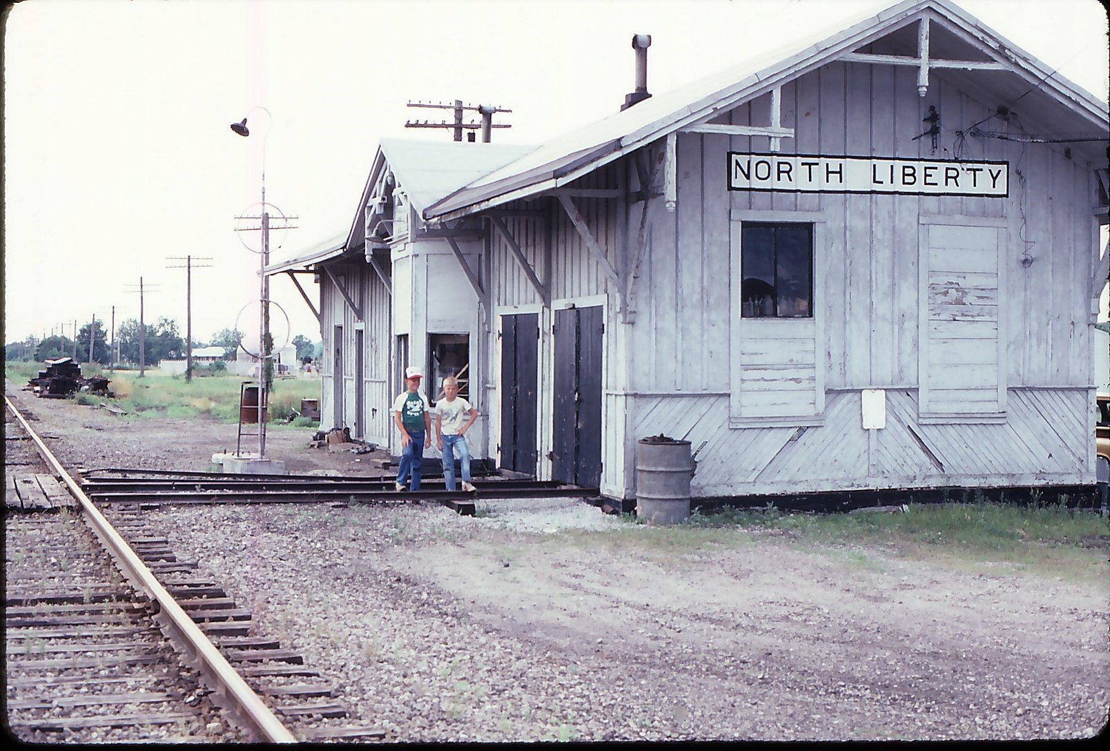
North Liberty, IN: Wabash Depot and Junction of Wabash vs. NYC

Depot: (Satellite, this is a guess based on a topo map.)
Junction: (Satellite, both of these railroads have been abandoned.)

The NYC route was the Kankakee Belt.

Roberta Crawford posted
North Liberty Indiana. This shot was probably taken from the old railroad water tower. The building to the right was The Beanery restaurant or the Foster's hotel  The restaurant on the first floor and rooms to rent on the second floor. Appears that the train is coming out of the roundhouse here.
Leif Erikson: 🙂 Wabash Railroad-4th District...🙂 Toledo to Chicago...
Tim Shanahan shared

George M Stupar posted three photos with the comment: "North Liberty Indiana on the Wabash Railroad 4th District in July 1984. One photo was taken in 1985 or 86."
1

2

3

1958 North Liberty Quad @ 1:24,000

Friday, May 3, 2024

Maryville, MO: Delapidated/Wabash Depot

(Satellite)

This is on the route that Jay Gould used to connect his Wabash Railroad with the UP in Omaha.

Street View, Jun 2023

Raymond Storey posted

Andy Brown commented on Raymond's post
Taken just last year

Sunday, March 17, 2024

Campus, IL: Wabash Depot (U) and Extant Water Tower

Water Tower: (Satellite)
Depot: (Satellite, according to the aerial and the background in the photos, west of the tracks and a little south of Centre Ave.)

Richard Fiedler posted five photos with the comment: "Wabash Railroad at Campus Illinois MP 72.8 South of Dearborn Station Chicago on the 6th district. The depot is a standard Chicago and Strawn RR depot measuring 18'x36' built in 1880 Telegraph call “U”. The steel water tower from the Wabash's water stop at Campus still exists as the only tangible reminder that the Wabash went through here as NS abandoned and dismantled the line in 1991-3.  All photos Robert Fiedler collection."
[A comment indicated that Wabash also called this route the Forest Division.]
James Holzmeier: Richard why was the order board set so far out from the depot at this location?
Richard Fiedler shared
Richard Fiedler: Richard Mead my understanding is the old railroad tower is no longer in use due to corrosion and its duties were transferred to the modern tower next to it.
Richard Fiedler shared
1

2

3
Jimmy Fiedler updated
Ned Calvin: Clear train order boards

4

5
 
Richard Fiedler responded to James' question
I don't know. Perhaps for visibility. There were cantilevered order boards elsewhere on this division. Essex IL

Richard Fiedler responded to James' question
Manhattan second depot there.
 
Dave Degroot posted
Campus, IIlinois
 Wabash RR water tank.

The above post is scary because Dave references these notes, yet I could not find that photo in these notes! I have no idea why the photo disappeared from the notes. So now I don't know the original source of the photo. The following confirms it was not a street view.
Street View, Jun 2024

1940 Aerial Photo from ILHAP

While checking out the grain elevator on the north side of town, I noticed in the right background that there is another elevator further north.
Street View, Sep 2009

In addition to a long building, that northern elevator uses a long ground pile for expanded storage.
Satellite

The satellite caught them running an elevator to create the ground pile.
Satellite

In 2009, they were building something at that elevator.
Satellite

Saturday, October 14, 2023

Clayton, IL: Lost/Wabash Depot, Roundhouse and Water Tower

Depot: (Satellite)
Roundhouse: (Satellite, the land has been repurposed)

Andy Zukowski posted
The Wabash Railroad, Depot and Round House in Clayton, Illinois. C1910 Photo by CU Williams
Steven Zickar: Way back when the Meridosia Branch went all the way to Keokuk.
Danny Cole posted a B&W exposure
Richard Fiedler shared

Dennis DeBruler commented on Steven's comment
 The Meredosia Branch also went to Quincy, IL. I learned that when I studied a photo of the Wabash depot in Quincy. In fact, the Meredosia Branch split into the two different routes in Clayton. The curved track we see in Andy's photo goes north to Keokuk while the track on the left side of the photo continues West and joins the CB&Q route in Camp Point, IL.
 https://idot.illinois.gov/.../1928-historic-rail-map.pdf
Larry Candilas: Dennis DeBruler On the 1928 map it looks like there were parallel tracks but on older maps it looks like Wabash had trackage rights on the CB&Q. Was this always the Wabash, and was it the main route of the branch with the Clayton to Keokuk line a branch of the branch?
Dennis DeBruler: Larry Candilas I think the parallel red and blue lines is IDOT's way of showing shared usage of a route. The 2005 SPV Map shows that Wabash used CB&Q's track.
Ever since I wrote the notes about the Wabash depot in Quincy, I wondered if the bridge across the Illinois river was built with the intention to go to Quincy or to Keokuk or to both.

Dennis DeBruler commented on Andy's post
This 1938 aerial photo shows the depot between the branch that curves north to Keokuk and the branch that continues straight to Quincy. But the roundhouse appears to be gone already.
 https://clearinghouse.isgs.illinois.edu/webdocs/ilhap/county/data/adams/flight6/00sa191745.jpg

Larry Candilas commented on Andy's post
Why an engine house in the not-so-booming town of Clayton? Maybe somebody can help with this mystery concerning a branch-line leaving the Keokuk line and going west to Camp Point where it connected with the CB&Q mainline to Quincy. Here it is on the 1872 county map and it's still there on the 1928 state map. Anybody know anything about this?
Andy Hughes: Larry Candilas Sure the steam engines required a huge amount of maintenance and a balance had to be struck between a centralized maintenance point and a smaller one to help expedite things along. When diesels came in the efficiencies were enormous. With a small branch line engine they could do a patch job and then when a relief engine is dropped off at Bluffs they can make a switch. Then the engine either gets fixed at Springfield mini shops or Decatur. The faster the fix, the better. In the mid fifties Trains Mag had a farewell to Wabash steam. Here, we had the Mogul 576 hanging on because the rickety (yet beautiful) bridge across the Ill River at Meredosia couldn’t handle a GP-9. This really beautiful engine is in the StL transport museum in Kirkwood. The end came and sadly the line was cutoff at Meredosia. With the bridge gone, Wab got trackage rights on the Burlington to gain access to Keokuk, IA. My custom license plate was WAB 576 (?). Kinda forgot the last digit but I’ll never forget the beautiful lines of her.
Dennis DeBruler: Larry Candilas There is a photo of the Wabash depots in Quincy and Camp Point in these notes:
https://towns-and-nature.blogspot.com/2016/06/quincy-il-wabash-depot.html

Marilyn Sidwell posted
Clayton,IL
David Hahn: Does one line go to Keokuk and the other Camp Point?
Bill Edrington: David Hahn - Yes. The Wabash abandoned the Clayton-Camp Point line in the 1930s.
North of Green Street between Madison and Monroe. Here is a link to a Sanborn Fire Insurance Map showing the location:
https://www.loc.gov/resource/g4104cm.g017961898/?sp=2&r=-0.127,0.275,1.252,0.659,0
 
Sanborn Map


The town's grain elevator has a bunch of small bins in addition to some big bins. It also had the "walls" for a ground pile.
Street View, May 2012

The collection of really small bins and a couple of feed trucks indicates that it is also a feed mill.
Street View, May 2012

Sunday, January 7, 2018

South Bend, IN: Aban/NS/Wabash/NJI&I Depot & Administrative Offices and Roundhouse

Depot: (Satellite)
Roundhouse: (Satellite)

One of the red signs has fallen off since ChicagoSwitching (source) took some pictures. The NJI&I is the New Jersey, Indiana and Illinois.
Street View

Roundhouse


Roberta Crawford posted
Time lapse of the NJI&I Railroad roundhouse on Olive Street in South Bend. Photos are, top to bottom,1948, 2001, 2017 successively.The NJI&I was the personal railroad for the Singer sewing machine plants on Western Avenue and junctioned with the Wabash RR east of North Liberty.
Richard Fiedler shared
Daniel C Carroll Jr. shared
Guerney Josh: I tried to save it but NS had other plans for it. Built by the Singer sewing machine company.
Richard Fiedler shared
Tim Shanahan shared
Mike Snow: I was able to tour this before it was tore down, all the records was still there, the NJ&I had many customers and moved many cars in its heyday!

Guerney Josh commented on Daniel's share

Guerney Josh commented on Daniel's share

Keith Wilson commented on Roberta's post
You can still see where it was.
[Satellite]

1958/59 South Bend West Quad @ 24,000

And this is how the NJI&I got on up to its depot by Western Avenue. The corridor of railroads crossing Olive Street, from north to south, were NJI&I, GTW and NYC.
1958/59 South Bend West Quad @ 24,000

Friday, December 22, 2017

Topeka, IN: Wabash Depot

(Satellite, Street View)
Richard Roberts posted two photos with the comment: "Wabash Depot and caboose in Topeka,IN."
They have preserved the train order signals. This is on the Wabash segment that has been abandoned between South Milford and Chicago.
1

2

Friday, September 29, 2017

Streator, IL: Junction Tower: BNSF/Santa Fe vs. Aban/N&W/Wabash

(Satellite)
Kerry Bruck posted
ATSF Hudson steam locomotive #3461 crosses the Wabash diamonds in Streator 1947
John Burt Alan, this was the tower at the Lundy Street crossing.

In the aerial, it appears the tower is parallel to the Wabash tracks but north of the junction along the Santa Fe tracks. It appears the Hudson is running timecard east. Those are the largest code lines I have ever seen in a photo --- 8.5 crossbars.
1939 Aerial Photo from ILHAP
William Shapotkin posted three photos with the comment:
Sreator, IL ATSF/WABASH Xing. Here are three pix of the Tower/Xing of the ATSF/WABASH in Streator, IL. Now allow me to say that the interior photo was furnished me by a fellow on one of the facebook discussion groups and (sorry, it is my fault), did not write down his name so that proper credit can be given -- and for that I humbly apologize.
Richard Fiedler William I posted the interior photo to you but in fairness I believe I got it from the Streator IL site.

1

2

3

Sunday, September 24, 2017

Custer Park, IL: Wabash Depot and Water Tower

(Satellite)

Richard Fiedler commented on Richard Mead's posting
Depot and wood water tower about 1910
 
Andy Zukowski posted
Wabash Depot in Custer Park, Illinois. 1946
Richard Fiedler shared

Larry Binns posted
Wabash RR Depot and water tower, Custer Park.  Custer Park Hotel on right.
Richard Fiedler: Probably a view from 1910-20.
Richard Fiedler shared

Richard Mead posted
1904 Shinaberger Hotel in Custer Park IL. photo north of Wabash depot.
Richard Fiedler commented on his first share above
View looking north and the train just came off the bridge over the Kankakee River. The pump house for Custer Park’s water tank (from which the photo was taken is just to the left of the locomotive. Depot roof is in the foreground and then the hotel.

Because Richard Mead's photo shows the view north of the depot is the bridge and the Kankakee River, I think the red rectangle below shows the depot and tower. The hotel in the aerial photos has a white roof.
1939 Aerial Photo from ILHAP plus Paint

Andy Zukowski posted
The Wabash station at Custer Park Illinois. Photo by Bill Raia
Richard Fiedler shared

Richard Fiedler posted seven photos with the comment: "Wabash depot facilities and surroundings Custer Park IL. The depot was a Telegraph agency early on but was not a telegraph agency after the turn of the century thus no semaphore train order signals. All structures except the bridge are long gone and the ROW is now a nature and bike trail owned by the Will County Forest Preserve District. Photo credits given as known."
Richard Fiedler shared
1
Article about the derailment at Custer Park on August 22, 1968 that took out the northernmost span and derailed 29 cars of which 23 went in the river. A thru girder replaced the truss span. I remember that N&W passenger trains detoured over the GTW and then on to the IC via Gibson City to reach Decatur for a while until the span was replaced. I believe a shifted load of a damaged boxcar strapped to a flat car snagged a girder and the rest was a mess.

2
2nd Wabash bridge at Custer Park built 1902 over the Kankakee River. The new bridge culminated a major line relocation in Ritchie that bypassed the town center of Ritchie and greatly straightened the line. Custer Park was to the right (south) and Ritchie was about half a mile to the north (left). The new steel bridge replaced an earlier wrought iron truss span from when the line was built 1879-80. One of the old iron spans survived until the late 70’s by being moved in 1902 and replaced another wrought iron span over the Vermilion River in Pontiac. Note the pump house that fed the tank at Custer Park on the right approach. No doubt pump tenders kept the steam pump working 24/7. The leftmost span was demolished in the late 60’s and replaced by a thru girder span after a spectacular derailment that put 23 cars in the river. 

3
Undated postcard view of the Custer Park depot best guess 1880-1890. Note the Tri-Color paint scheme of buff or crème, over gray, with red oxide trim but with a variation of what looks like white window sashes. Note as well the “Nunn” type train order signal that was later replaced by “Ecipse” semaphores. That alone dates this photo to pre 1890. WRHS c/o James Holzmeier 

4
View from atop the wooden water tower looking north. Train is coming off the Kankakee River Bridge. Note the hotel as this was quite the resort for people escaping from Chicago to vacation,fish, and connect with tranquility on the river. Depot roof in foreground. Photo David Zima collection. 

5
Depot and wood water tower 1910-15. Robert Fiedler collection. 

6
Depot mid 50’s. You can barely see the newer steel water tower in the far left corner. 

7
Blue Bird heading south about 1960. By this time the depot appears to be not staffed anymore or perhaps staffed part time. Note the high grass in the platform area. William Raia photo