 |
| Dan Miller posted, cropped Restored Sun Oil gas station relocated to Carillon Historical Park in Dayton, Ohio Bob Connors: Should have been an Ohio-based brand ... Sohio/Refiners, Marathon or Pure. Sun is more associated with PA. Dan Miller: Bob Connors There were numerous Sun Oil stations in Dayton. The only companies with a distinctive architectural style were the early Sun Oil and Pure Oil. |
Showing posts with label energyGas. Show all posts
Showing posts with label energyGas. Show all posts
Friday, April 3, 2026
Dayton, OH: Moved Sun Oil (Sunoco) Gas Station
(Satellite, I could not find the station itself. It is in the Carillon Historical Park.)

Thursday, April 2, 2026
Milford, NJ: 1930+1977 Gilbert Power Plant
(Satellite)
I included the Milford area in the topo map to document that these badlands in the satellite image used to be a paper company. Also, the Pennsylvania Canal used to run along the opposite riverbank.
Lou Schwarz posted five photos with the comment: "These are pictures of retired plant I worked at. Gilbert station in NJ. The old side went into production in 1930. Photo credits to my friend Joe."
 |
| 1 |
 |
| 2 |
 |
| 3 |
 |
| 4 |
 |
| 5 |
The coal-fired plant has been replaced by combined-cycle units.
 |
| gem |
The turbines and generators were provided by GE Power. [power-technology]
The power station is significantly west of Milford.
 |
| 1953/53 Riegelsville and Frenchtown Quads @ 24,000 |
I included the Milford area in the topo map to document that these badlands in the satellite image used to be a paper company. Also, the Pennsylvania Canal used to run along the opposite riverbank.
 |
| Satellite |
Thursday, January 15, 2026
Rome, NY: Erie, Black River & Barge Canals and Manufactured Gas
 |
| Matt Korona posted A empty Canal in Rome Ny |
The Erie Canal is today's Erie Blvd. The Black River Canal is today's NY-46 on the east side of downtown. The Barge Canal is extant and runs south of town. The pin marks where the Black River Canal joined the Erie Canal.
 |
| Satellite |
 |
| 1895/95 Oriskany Quad @ 62,500 |
Rome Gas and Electric Company Gasometers
(Satellite, northwest quadrant of Erie Canal and Madison to Jay Streets.)
Cori Willson posted four photos with the comment:
The Rome Gas and Electric Company (also known as the Rome Gas, Electric Light & Power Company or similar variations like Rome Gas and Electric Light and Power Company) was a key local utility in Rome, New York, during the late 19th and early 20th centuries. It produced and distributed manufactured gas (from coal/coke processes) for lighting, heating, and cooking, while also generating and supplying electricity as electrification grew in the industrial era..The company's main plant—specifically its coke and gas production facility—was located on the north side of the Erie Canal, just west of Madison Street. This placed it along the canal's industrial corridor in central Rome, where coal could be delivered by barge or rail for gas manufacturing, and waste/byproducts were managed nearby. The site included large gas holders (the cylindrical storage tanks visible in the photos), coal handling/unloading facilities (with elevated conveyors or bridges for moving materials arriving from the rails along the south side).Rome was an industrial center in that era—known as the "Copper City" for metalworking and manufacturing—boosted by the Erie Canal for transport of coal, goods, and people. Utilities like this one powered factories, streetlights, and homes during the transition from gas lighting to electricity. The plant tied into broader energy developments, including occasional natural gas finds in the region, though manufactured (coal) gas dominated locally until natural gas pipelines expanded.The old Erie Canal through downtown Rome was later filled in, covered, or redeveloped in the 20th century (with parts paralleled or replaced by modern infrastructure like Erie Boulevard). The former manufactured gas plant (MGP) site—associated with this company—was specifically at the Jay and Madison Streets area. By the late 20th century, it became a documented former MGP site under successors like Niagara Mohawk Power Corporation (later National Grid), with environmental investigations and remediation in the 1990s–2000s for typical coal-tar residues and contamination from historical gas production.Looking west down the canal from the Madison Street bridge in the early 1900s, the Rome Gas and Electric Company's structures dominated the north bank. A standout in the 1918 photo—amid the barn-moving activity near the canal—was a sturdy, gabled industrial building that endured for over a century.That same structure was once a mill where I can barely remember buying horse feed with my grandfather. It later became Long's Auto Electric, a family-owned auto repair and parts shop specializing in electrical work. it was located at 425 Erie Boulevard West—one of the last surviving remnants of the old Erie Canal era along the boulevard, after the canal was filled in, covered, or realigned in the 20th century (with Erie Boulevard tracing much of its former path).Sadly, the building is now gone: damaged by the July 2024 EF2 tornado that ravaged Rome, it sat vacant for years before the city acquired it in late 2024/early 2025. Demolition by Gorick Construction began in July 2025 as part of a broader $333,000 cleanup and redevelopment effort along the Erie Boulevard corridor, erasing one of the final tangible links to the area's industrial canal days.
.jpg) |
| 1 |
.jpg) |
| 2 |
The building in Photo 4 is on the left in this Jul 2025 street view.
.jpg) |
| 3 |
.jpg) |
| 4 |
Wednesday, August 27, 2025

Monday, September 9, 2024
Pittsburgh, PA: 1800s+1929+1972 Brunot Island Power Station
(Satellite)
Since 1974, it has a peaking combined-cycle output of 340mw. [gem]
 |
| Phil Jadlowiec posted Sharing from another group. |
.png) |
| HistoricPittsburgh Jun 1, 1930 "as seen from Sheridan." |
In the 1800s, the land "was purchased by entrepreneur and engineer George Westinghouse for his Pittsburgh Railways Company. An electric generating station was constructed, along with a railroad bridge that traversed the island to each bank of the Ohio River....Duquesne Light took over management of the generating station during the early 20th century and...workers would go across to the generating station using the railway bridge, which is still true today."
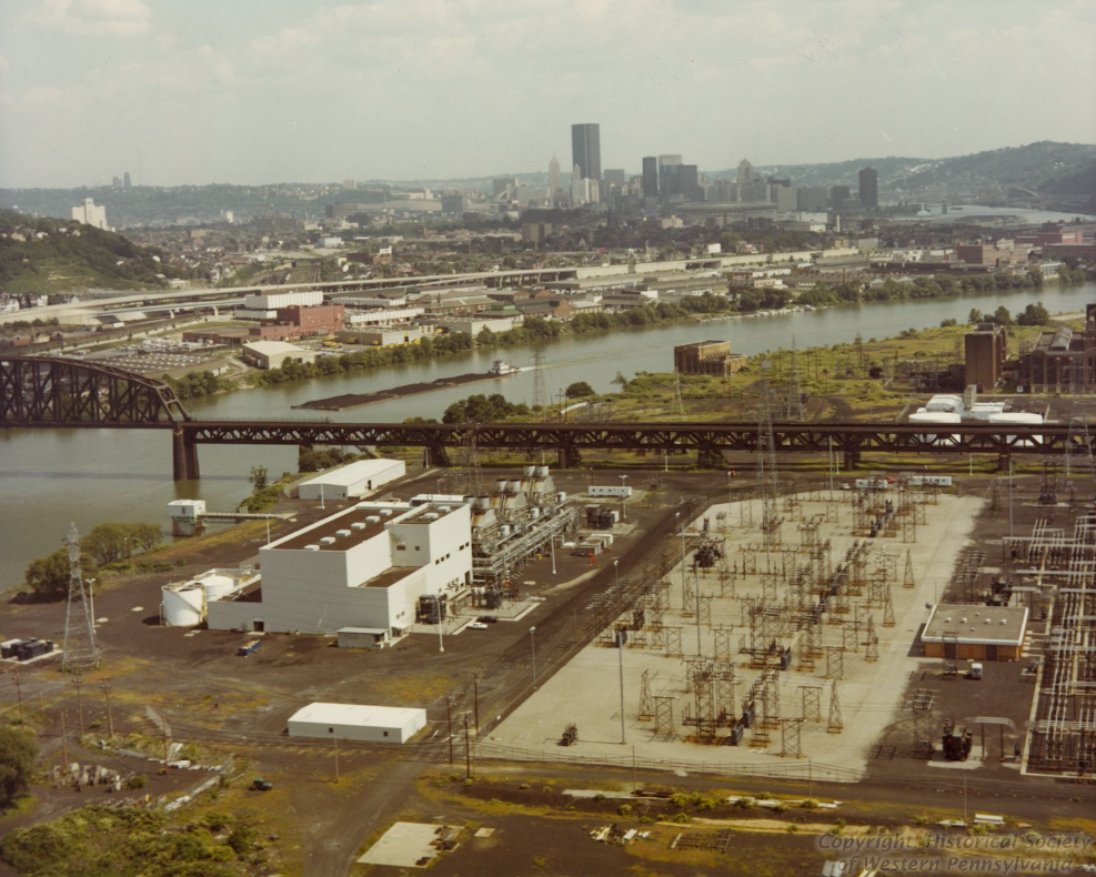 |
| HistoricPittsburgh In 1972, it began burning oil in six simple cycle peaking units. [It now burns natural gas. Fracking provides cheap natural gas from Pennsylvania's extensive shale beds.] |
No street view driver has taken the ferry to the island.
 |
| Street View, Apr 2012 |
 |
| nps_part_2 Photo: Brunot Island, 1929, with Reed Power Station Under Construction. Duquesne Light Photograph Collection |
The power plant is in the left background of this photo.
 |
| Joseph Cermak Flickr posted by Mtnclimberjoe Rail Photography via Dennis DeBruler |
This view shows the river bluff that causes the NS/Pennsy bridge to be so high over the island.
 |
| 1:40 video @ 0:37 |
Friday, May 19, 2023
Malvern, AR: Entergy Lake Catherine Power Station
(Satellite)
There is no railroad associated with this powerplant because it appears that it used fuel oil and then natural gas.
David A Mitchell posted a video and five photos with the comment: "Entergy Lake Catherine Units 1,2,&3."
 |
| Mikey G, Sep 2022, cropped |
David A Mitchell posted a video and five photos with the comment: "Entergy Lake Catherine Units 1,2,&3."
 |
| 0:35 video @ 0:07 |
 |
| 2 |
 |
| 2 |
 |
| 3 |
 |
| 4 |
 |
| 5, cropped [I left some of the color of the casing at the bottom to confirm that this was the unit you see about half way through the video.] |
 |
| Dennis DeBruler commented on David's post Thanks for including the name plates. I learned a lot from them. This 184mw of capacity was retired in 2013. It appears that these units were fired with fuel oil. This image is from Google Earth, Mar 2017. The tanks are gone in the next image, Nov 2018. Unit #4 was commissioned in Apr 1950, and it is 752mw and gas fired. |
It appears that the first two units shared the left smokestack, Unit #3 used the middle smokestack and Unit #4 uses the right smokestack.
 |
| Satellite |
Monday, February 20, 2023
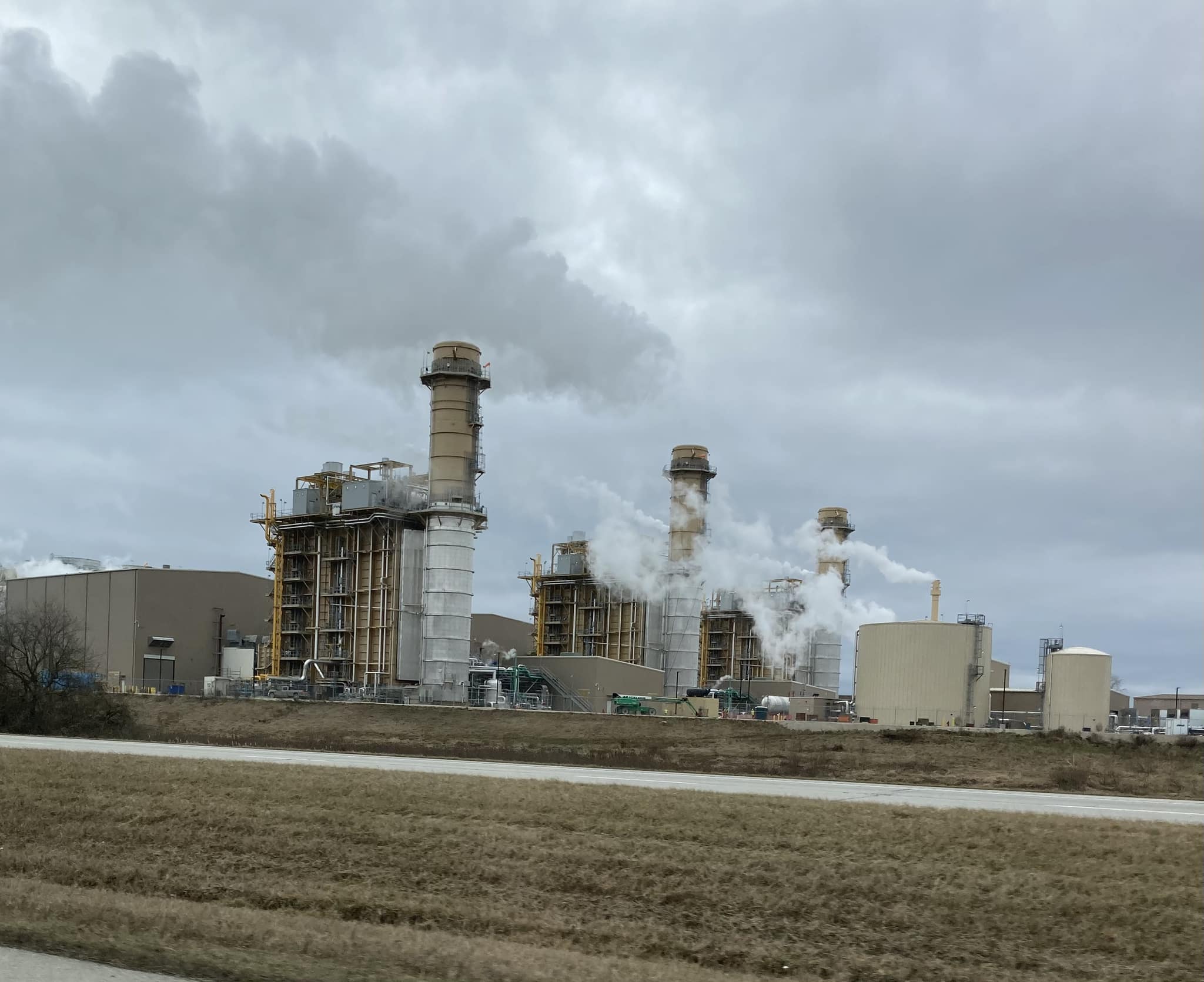
Byesville, OH: 2023 1.875gw Guernsey County Power Station
(Satellite, it was still a farm field when I accessed it)
That is an impressive array of coolers. Looking at a satellite map, there is no large lake or river nearby.
The Utica and Marcellus shale beds that I knew were in western Pennsylvania are also in this area (eastern Ohio). These are shale beds that fracking technology made productive. The plant was built next to a gas pipeline and a 765kv power line. [GuernseyPowerStation-facts]
 |
| Eric Wasson posted Guernsey Power Station now [Feb 2023] up and running in Ohio. Paul Dildine: They are single shaft 7HA.02, the GT, generator, and steam turbine on the same line shaft. The steam turbine has a 'triple s' clutch so the GT can be run in simple cycle until steam quality is good. This is the same arrangement as Lackawanna energy center and moxie freedom. The former ops manager from Lackawanna is plant manager at Guernsey. Erich Amberger: Drew Bednarczyk They are 7HA.02 @ 384mw X 3. And it says the plant is 1875 mw. Looks like it says “ STG FOR EACH 7HA.02” so that would be 241 mw STG X 3. But if you look at GE site 1X1 is only 573 each🤷♂️ |
 |
| GuernseyPowerStation |
That is an impressive array of coolers. Looking at a satellite map, there is no large lake or river nearby.
 |
| GuernseyPowerStation |
 |
| Photo by Heather Sevingy via daily-jeff, May 2021 The project was projected to cost $1.6b, and it will employ about 30 people with more people during the spring and fall outages to prepare for the next season. "The plant will be the largest natural-gas powered facility in the United States that was built in a single phase, designed to last 30 years." "Early stages of the construction phase included six months of site preparation work to include approximately 200,000 cubic yards of grouting in mines abandoned in the 1920s. Approximately 10 to 12% of the project budget involved site preparation." "One megawatt will power 800 modern homes and the plant can supply up to 300 megawatts to the grid in 10 minutes with the push of a button." [This is a nice article. They briefly explain how a combined-cycle power plant works.] "The plant will use 160,000 MMBTU (1 million British thermal units) or 1,000 MCF (volume of 1,000 cubic feet) a day." |
"The Guernsey Power Plan was able to bring all of the big equipment in on rail lines reducing the impact on local roadways." [daily-jeff] A satellite image shows that tracks go right past the west side of the site. But, the 2005 SPV Map shows that PennCentral abandoned this Pennsylvania route south of Byesville. I wonder how much work was needed to restore the tracks to the plant.
GE's 7HA.02 gas turbines are "the world’s largest and most-efficient heavy-duty gas turbines....The HA turbine has been recognized for powering the world’s most efficient power plants in both the 50hz and 60hz energy segments. GE’s fleet of HA gas turbines has surpassed more than 388,000 operating hours and secured more than 95 orders from 40+ customers in 18+ countries." [GE-press]
"Using state-of-the-art combined cycle technology and a dry (air) cooling system, the 1,875 MW, Guernsey Power Station, will be a cost and fuel-efficient plant. Each power train, in its own turbine building, will consist of one GE 7HA.02 gas turbine equipped with evaporative inlet cooling, one triple pressure reheat steam turbine and one water/hydrogen cooled electric generator arranged on a common single shaft. Each power train will have an outdoor heat recovery steam generator (HRSG) equipped with supplemental duct firing capabilities, selective catalytic reduction technology for NOx, and an oxidation catalyst for CO/VOC reduction." [GemmaPower]
"The Guernsey power station will receive natural gas supply from the Utica and Marcellus shale gas formations in eastern Ohio and western Pennsylvania, through the near-by Rockies Express (REX)-East pipeline. REX-East is a 1,028km-long and 42in-diameter high-pressure natural gas pipeline that originates from the Clarington natural gas hub in Monroe County of Ohio and runs through Ohio, Indiana, and Illinois to Missouri." [nsenergybusiness]
%20Caithness'%20Guernsey%20County,%20Ohio%20Natural%20Gas%20Power%20Plant%20Construction%20Site%20-.png) |
| 5:50 drone video @ 5:02 |
Sunday, December 18, 2022
Pleasant Lake, IN: Old Philips 66 Gas Station and Gas Station Density
(Satellite)
Because of the old Phillips 66 station in Baxter Springs, KS, this photo tripped by "twice in two days" rule.
Ed's comment reminded me that before satellite based credit card billing became possible, it was not unusual to have three filling stations at an intersection. If I remember correctly, Ogden and Main in Downers Grove, used to have three stations when we moved to this town in 1976. And the Speedway a couple of blocks to the East was an old fashioned Citgo before we moved here. Of course cars in the 1960s needed about twice as much gas per mile as they do today and a lot more repairs.
 |
| Terry Wisel Heintz posted, cropped Regina Lease: Oh wow is that the station that was located on the corner of us 27 and Bellfountaine rd. Where the Marathon station is now. Ed Miller Sr.: Remember this one well, it was beside the Martin I was talking about earlier, and across the street from it was a Standard station,west a few hundred feet was a Shell station on the south side as you went into P Lake |
Even the current station has a rather old design because it still has just one pump island. The service bay has been turned into a convenience store. And they got rid of the maintenance headache of flat roofs.
 |
| Street View |
Ed's comment reminded me that before satellite based credit card billing became possible, it was not unusual to have three filling stations at an intersection. If I remember correctly, Ogden and Main in Downers Grove, used to have three stations when we moved to this town in 1976. And the Speedway a couple of blocks to the East was an old fashioned Citgo before we moved here. Of course cars in the 1960s needed about twice as much gas per mile as they do today and a lot more repairs.
It appears that Ogden & Main used to have stations in all four quadrants because I know the southwest quadrant got a Standard Oil station. The east/west road is Ogden and the north/south road on the left is Main.
 |
| EarthExplorer: Apr 01, 1952 @ 17,000, AR1UC0000040009 |
 |
| EarthExplorer: Apr 20, 1962 @ 24,000, AR1VAHU00020143 |
 |
| EarthExplorer: Oct 26, 1972 @ 30,000, AR1VDCR00010436 |
Saturday, December 17, 2022
Baxter Springs, KS: 1930 Phillips 66 Gas Station and Route 66 Visitors Center
(Satellite, 229 photos Military Avenue was Route 66.)
US-66 Overview
There is also a preserved Route 66 rainbow arch bridge just north of this town.
I used these maps to confirm that Route 66 ran north/south through this town.
But everyone that I looked at had at most four pumps.
And some are no longer Phillips 66.
 |
| Street View, Jul 2016 |
I used these maps to confirm that Route 66 ran north/south through this town.
 |
| 1947 Joplin and 1954 Tulsa Quads @ 250,000 |
While looking for the Page 618 dragline in northeastern Cherokee County in Kansas, I came across this photo. That is what caused me to find this Route 66 museum.
 |
| Peter Cowling, Nov 2022 |
 |
| Ben Leary, Oct 2020 |
 |
| BaxterSpringsMusuem-visitors-center |
Fan belts did not last as long back then.
 |
| M Jimenez, Nov 2022 |
I haven't seen a Phillips 66 gas station in the Midwest in decades. I had assumed they had been bought by someone and no longer exist. But I see there are still a lot of them down here.
 |
But everyone that I looked at had at most four pumps.
 |
| Street View, Jun 2019 |
And some are no longer Phillips 66.
 |
| Street View, Jun 2019 |
The other Route 66 town in Kansas is Galena.
Subscribe to:
Posts (Atom)