 |
| 23:17 video @ 12:50 1830 Gaston's Mill - Two Centuries of History |
These are notes I am writing to help me learn our industrial history. They are my best understanding, but that does not mean they are a correct understanding.
Showing posts with label energyHydro. Show all posts
Showing posts with label energyHydro. Show all posts
Saturday, August 2, 2025
Tuesday, May 20, 2025
Thorp, WA: 1883 Thorp (Grist) Mill
(Satellite)
I'm always on the lookout for examples of line-shaft power.
While looking for a couple of Milwaukee tunnels, I discovered this mill.
 |
| Street View, Jul 2023 |
 |
| Street View, Jul 2023 |
 |
| thorp "The four-story building had a 75-barrel daily capacity and produced flour and livestock feed. Originally a stone buhr mill, the facility was later converted to a roller mill at the end of the 19th Century. The Thorp Mill still retains its original rollers, and plans are underway to restore many of these machines back to working order....The mill was powered by water from a diversion dam on the Yakima River that was used to move a lateral turbine system. A second turbine on the site, used to power the adjacent lumber mill, was later employed to provide the first electrical power to the area. In 1989, the Thorp Mill Town Historical Preservation Society restored the mill’s turbine, making it once again operational." |
 |
| MillPictures |
From their virtual tour. The popup came from clicking the left-most "coffee cup." The photos are 360 degrees so this is just a fraction of what you can see.
 |
| lapentor |
In the photos I saw of the mill, I've seen sign numbers as high as 10, so the mill has a nice self-guided tour. They also offer guided tours.
 |
| Ben Coogan, May 2024 |
 |
| Roy Grinnell, Jul 2022 |
 |
| Troy Collins, Oct 2024 |
 |
| Roy Grinnell, Jul 2022 |
Monday, May 12, 2025
Paterson, NJ: 11mw Great Falls, first planned industrial city in USA, and hydro plant
Power Plant: (Satellite)
This is the museum building. Both the Rogers Locomotive & Machine Works and the Grant Locomotive Works were in Paterson, NJ.
Museum: (Satellite)
(HAER, the server was broken when I tried to access the photos.)
%20Facebook.png) |
| Facebook Reel The Great Falls is 77' (23.5m) high and has a flow second only to Niagara Falls in Eastern USA. |
 |
| nps, Terry McKenna "When Alexander Hamilton and the Society for Establishing Useful Manufactures (S.U.M.) set out to build the first planned industrial city in America in 1792, the key factor was waterpower. Paterson’s industries clustered around the raceway system built by the company, harnessing the potential energy of the Passaic River and the 77-foot drop in elevation with a three-tiered, human built network of artificial channels. Water, diverted above the great falls, flowed through this system, and drove water wheels, and later, turbines. The mechanical, kinetic energy was connected to machines throughout each factory by a network of shafts, gears, belts, and pulleys." |
Here is a stronger flow over the falls.
 |
| nj |
.webp) |
| nps, Paterson Museum All of the factory sites along the raceways were occupied by the 1850s. So, when electric power became viable, they switched to the new form of power distribution. |
 |
| nps, Paterson Museum "The plant as built had four 2400-volt, sixty-cycle alternating Westinghouse generators." |
Today, the power plant has "three vertical Kaplan turbine generators" that were installed in 1986. [EagleCreekRE]
The fourth unit was preserved, inoperable. [nps]
 |
| PatersonGreatFalls Today, the three tier raceways and 118-acres of old factories are a national park. "The waterpower system fostered many technological advances in industry, such as the first cotton duck cloth for sails, the first continuous sheet paper, the first revolver by Samuel Colt, and the first practical submarine by John Holland. Paterson became the world's center for the production of cotton, silk and locomotives." |
The upper raceway is now a park. The first tier of the raceways went south of the river along the escarpment.
 |
| PatersonGreatFalls_map |
This is the museum building. Both the Rogers Locomotive & Machine Works and the Grant Locomotive Works were in Paterson, NJ.
 |
| Street View, Nov 2020 |
Tuesday, May 6, 2025
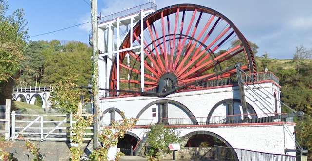
1854 Great Laxey Wheel or Lady Isabella in Laxey, Isle of Man
(Satellite)
I knew that pumping water out of mines drove the development of steam engines. I did not know that it also drove the development of water wheels to such big wheels.
 |
| Paul Hollinghurst, Aug 2015 |
 |
| Street View, Oct 2010 |
 |
| Traveling the world to see inspiration posted Perched on the hillside above the village of Laxey on the Isle of Man stands an awe-inspiring feat of Victorian engineering—The Laxey Wheel, affectionately known as "Lady Isabella." Built in 1854 and designed by engineer Robert Casement, this massive waterwheel remains the largest functional one of its kind in the world. With a diameter of 22.1 meters (72 feet 6 inches) and a width of 1.8 meters (6 feet), it turns majestically about three times per minute, powered entirely by water. The Laxey Wheel was originally constructed to pump water from the Glen Mooar section of the Great Laxey Mines, once one of the most important industrial sites on the island. Today, it stands not just as a monument to the island’s rich mining heritage, but as a symbol of its innovation and resilience during the Industrial Age. Visitors from across the globe come to marvel at this mechanical giant, which continues to capture imaginations just as it did over a century ago. More than a historic structure, the Lady Isabella is a proud reminder of the Isle of Man’s engineering legacy and industrial spirit. |
I knew that pumping water out of mines drove the development of steam engines. I did not know that it also drove the development of water wheels to such big wheels.
 |
| Alan Jones (deadmanjones), May 2024 |
 |
| Ferdy Bailey, Aug 2023 |
Wednesday, March 12, 2025
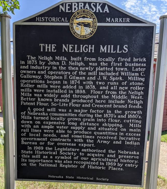
Neligh, NE: 1874 Museum/Water Powered Flour Mill
(Satellite)
The museum includes an outside braced boxcar.
It looks like the line shaft for these machines is running along the floor.
 |
| Nebraska State Historical Society posted ✨Sites Spotlight✨ The Neligh Mill and the Elkhorn River have had a complicated relationship. Once essential to operate the mill's water turbine to grind local grain, the river's water level also limited production at times. To operate 24/7, the river also provided hydroelectricity for the mill and the city of Neligh from 1900 to 1915. It wasn't until the dam was damaged during the Flood of 1920 that the mill's trajectory changed forever, forcing the abandonment of water power in favor of electricity. To learn more, visit https://history.nebraska.gov/neligh-mill-state-historic.../ |
 |
| nebraska_history, photo is about 1885 |
 |
| nebraska_history, photo is about 1909 |
The museum includes an outside braced boxcar.
 |
| Street View, Jul 2024 |
 |
| zac johns, Jul 2020 |
A line shaft is preserved, but the leather belts are missing.
This equipment is from the 1880s. [nebraska]
 |
| Harland Schuster, Jul 2023 |
The belt in this photo probably went to a line shaft. I noticed that they use chains for secondary power distribution.
 |
| Tom Harden, Sep 2017 |
Some more belts that have survived.
 |
| Joe Pinkerton, May 2017 |
 |
| Nali Yan, Mar 2018, to get this copy at photo resolution, I had to include the toolbar in the lower-left corner. |
I found a higher resolution copy of the part that I had trouble reading.
 |
| grandkids09caden@google.com, May 2017 |
The Leffel turbine was a tradename for a Francis turbine. [Dennis DeBruler]
I suspect that this photo was taken to document flood damage. Normally, water would go through the turbine, not under it.
 |
| nebraska_photos |
 |
| James Brookhouser, Sep 2024 |
 |
| James Brookhouser, Sep 2024 |
Did they use this steam engine to supplement the waterpower until they switched to electricity and diesel power supplements?
 |
| Joe Pinkerton, May 2017 |
It looks like the line shaft for these machines is running along the floor.
 |
| Melissa Mona, Aug 2019 |
 |
| nebraska_flour "Neligh Mills was one of the largest flour mills in Nebraska with a peak production of 98,000 pounds of flour per day from 1900 to 1920. The Depression of the 1930s forced many Nebraska mills to close, but Neligh Mills was resilient and survived. "Gold Medal flour was produced at the mill until May of 1940 when General Mills paid the mill $5,000 to become the sole owner of the brand name. See an original Neligh Mills Gold Medal Flour sack on display at the mill today." |
This photo shows the wood elevators were next to the mill building. So they have been torn down by 2024.
 |
| nebraska_photos |
I looked for the wood grain elevators in the above photo on a satellite map, but I could not find them. I did find them in an older street view. Unfortunately, I forgot to record the link, and now I can't find that view again. Bummer.
 |
| Street View, Mar 2018 |
The wood elevators were still standing in Jan 2020.
 |
| Google Earth, Jan 2020 |
The town's grain elevator is big given that they lost their C&NW rail service.
 |
| Street View, Jul 2024 |
Thursday, February 27, 2025
Grand Rapids, MI: Grand Trunk Depot
(Satellite, the post office reused the depot's land.)
 |
| Gordon 'Tim' Curtis posted Grand Rapids, Michigan. Grand Trunk Depot, Postmarked 1907 Jim Starkey: This is where the downtown post office is today. Jim Kelling shared Grand Rapids, Michigan (Grand Trunk Western) |
This map confirms that the purpose of the dam was to divert water into a headrace.
 |
| Dennis DeBruler commented on Jim's share The GTW had to use a spur along the river to access the station. 1914/14 Grand Rapids Quad @ 62,500 |
 |
| Walter Jung posted A rare Mr. Rover postcard, hustling past the Grand Rapids Michigan Union Station - postmarked and dated 1907. Tim Shanahan shared The clock at the top still exists today. It was saved. |
Sunday, December 15, 2024
Richmond, VA: Tredegar Iron Works
Buildings: (Satellite, the buildings have been repurposed as an American Civil War Museum.)
The waterwheel at the corner of the building reminds one that steam power did not replace waterpower until later in the 19 Century.
Rolling Mill Display Pavilion: (Satellite, it was removed between May 2018 and Apr 2020.)
This display pavilion no longer exists.
 |
| Street View, Apr 2015 |
Rick Rowlands posted six photos with the comment:
Does anyone know what happened to the rolling mill, flywheel and roll lathe that used to be on display at the Tredegar Iron Works in Richmond, VA? Google Earth shows that the machinery and shelter was in place in 2018 but gone by 2020. It was once part of the Tredegar Iron Works historic site but appears that half of that property is now torn up for the construction of an Ampitheater.Everything in these photos is now gone.
Rick Rowlands: I think I may have a lead on where the rolling mill is now at, if it has not been scrapped.
 |
| 1 |
 |
| 2 |
 |
| 3 |
 |
| 4 |
 |
| 5 |
 |
| 6 |
 |
| Hannah Tetuan, May 2018 |
 |
| I.E. Xam, May 2016 |
The waterwheel at the corner of the building reminds one that steam power did not replace waterpower until later in the 19 Century.
 |
| Street View, May 2022 |
 |
| Danielle Bellak, Jun 2019 |
 |
| Serge A, Jan 2019 |
 |
| Danielle Bellak, Jun 2019 |
 |
| Danielle Bellak, Jun 2019 |
 |
| Stanley Short posted via Dennis DeBruler Westbound Chesapeake & Ohio manifest No. 91 is at the west end of the James River Viaduct in Richmond, VA on May 15, 1983, led by GP30 No. 3024. It is taken from the old Lee Bridge (U.S. 1), which has since been replaced. Thankfully, it is still possible to shoot from the new bridge. That said, the scene has changed dramatically. The Federal Reserve Bank in the upper left and the James Monroe Building, to its right, remain. The brick building on the left is the old Tredegar Iron Works, which predates the Civil War. It has since been restored as a museum. [my emphasis] The area in the lower center and right of the image is now a beautiful public park, with plenty of parking. The smoke stacks are gone, and much of the center and background are occupied by high rise buildings. One added note, the small sliver in the middle extreme right was part of a dam across the James River. It remains and extends out into the river several hundred feet. It is part of the park and a viewing platform has been built at the end, providing a nice vantage point for shooting eastbounds on the viaduct. |
Last image with the pavilion:
 |
| Google Earth, May 2018 |
Last image with the concrete slab of the pavilion:
 |
| Google Earth, Sep 2023 |
Another example of old industrial buildings making great event spaces:
 |
| Tyler Phenes, Sep 2021 |
Subscribe to:
Posts (Atom)

