Buildings: (
Satellite, the buildings have been repurposed as an American Civil War Museum.)
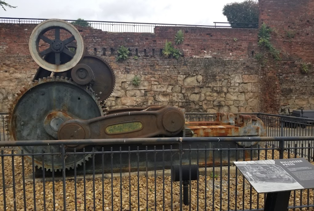
Rolling Mill Display Pavilion: (
Satellite, it was removed between May 2018 and Apr 2020.)
This display pavilion no longer exists.
Rick Rowlands
posted six photos with the comment:
Does anyone know what happened to the rolling mill, flywheel and roll lathe that used to be on display at the Tredegar Iron Works in Richmond, VA? Google Earth shows that the machinery and shelter was in place in 2018 but gone by 2020. It was once part of the Tredegar Iron Works historic site but appears that half of that property is now torn up for the construction of an Ampitheater.
Everything in these photos is now gone.
Rick Rowlands: I think I may have a lead on where the rolling mill is now at, if it has not been scrapped.
 |
| 1 |
 |
| 2 |
 |
| 3 |
 |
| 4 |
 |
| 5 |
 |
| 6 |
The waterwheel at the corner of the building reminds one that steam power did not replace waterpower until later in the 19 Century.
 |
Stanley Short posted via Dennis DeBruler
Westbound Chesapeake & Ohio manifest No. 91 is at the west end of the James River Viaduct in Richmond, VA on May 15, 1983, led by GP30 No. 3024. It is taken from the old Lee Bridge (U.S. 1), which has since been replaced. Thankfully, it is still possible to shoot from the new bridge. That said, the scene has changed dramatically. The Federal Reserve Bank in the upper left and the James Monroe Building, to its right, remain. The brick building on the left is the old Tredegar Iron Works, which predates the Civil War. It has since been restored as a museum. [my emphasis] The area in the lower center and right of the image is now a beautiful public park, with plenty of parking. The smoke stacks are gone, and much of the center and background are occupied by high rise buildings. One added note, the small sliver in the middle extreme right was part of a dam across the James River. It remains and extends out into the river several hundred feet. It is part of the park and a viewing platform has been built at the end, providing a nice vantage point for shooting eastbounds on the viaduct.
|
Last image with the pavilion:
 |
| Google Earth, May 2018 |
Last image with the concrete slab of the pavilion:
 |
| Google Earth, Sep 2023 |
Another example of old industrial buildings making great event spaces:


No comments:
Post a Comment