The Blackhawk Railway Historical Society posted two photos with the comment:
The Wilmington Area Historical Society - Illinois is looking for someone who would like to take possession of the former Wabash Railroad's North Ritchie (Illinois) depot.Ritchie is an unincorporated community in southern Will County, Illinois, United States. It is located along Forked Creek and Illinois Route 102, three miles southeast of Wilmington in Wesley Township.Ritchie is on the north bank of where the Wabash's Decatur-Chicago line crossed the Kankakee River. The Wabash right of way through there is now part of the Wauponsee Glacial Trail.The depot was preserved and moved from its original location to a farm in the area. The farm's new owner is not interested in keeping the building and is working with the Wilmington Area Historical Society - Illinois to find the depot a new home.All inquiries about the North Ritchie depot should go to William Weidling at 815-931-9079.(Blackhawk Railway Historical Society has no financial or other interest in this property. We only would like to see it preserved.)
Richard Fiedler shared
Richard Fiedler shared
The Blackhawk Railway Historical Society shared
 |
| 1 |
 |
| 2 |
 |
| Richard Fiedler commented on the above post |
 |
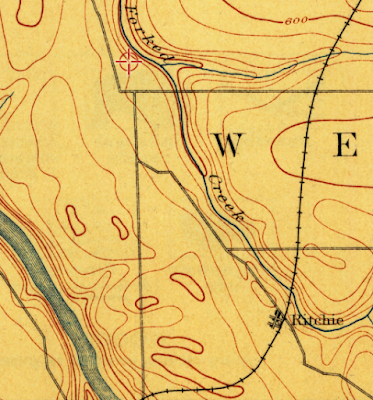
| Dennis DeBruler commented on the above post This is the newest topo map that has the old route. 1892/1911 Wilmington Quad @ 62,500 |
 |
| Dennis DeBruler commented on the above post This is the oldest topo map that has the new route. 1918/18 Wilmington Quad @ 62,500 |
 |
| Dennis DeBruler commented on the above post This 1939 aerial photo is of what the 1918 map labelled as "Ritchey Sta." The buildings in the aerial are consistent with the photos in this post. |
 |
| Dennis DeBruler commented on the above post This is what Ballou looked like in 1939. |
 |
| Dennis DeBruler commented on the above post The grain elevator at Ritchey Station survived even though the railroad was removed. https://maps.app.goo.gl/xsb1uVum8ZcfPyoq5 Richard Fiedler: Dennis DeBruler aerial views over the general area still show the general line of the original route. |
 |
| Dennis DeBruler commented on Richard's comment Since the 1892 topo map shows me where to look, one can easily spot tree lines on the southern and northern part of the route. And I verified with a 1939 aerial photo that Wesley Road was built on the RoW. https://maps.app.goo.gl/dvF7jG5gMTThTf7y8 https://clearinghouse.isgs.illinois.edu/webdocs/ilhap/county/data/will/flight17/0bxk03054.jpg |
On the right, I included the two big tanks that I noticed in the satellite view. Do they hold fertilizer?
 |
| Street View, Oct 2022 |

No comments:
Post a Comment