Wednesday, August 27, 2014

Corvettes, Old Tractors, and Old Gas Engines


I went downtown to catch the Corvettes at the Downers Grove Classic Car Night. One was on its way to Curtiss street as I walked down Main.
And below is an overview of the action on Curtiss Street.

20140822 0006
A closer look.


And across the street.


I was out of town for my favorite Classic Car Night night---trucks and tractors. But I noticed in Michael Matalis' Photostream that he caught pictures of a Farmall, M John Deere, Super A Farmall, H Farmall, and a WD45 Allis Chalmers. (I'm assuming that photostream links are permanent. I'm not a Flick guru.) When I was a kid, I drove the tricycle version of the H Farmall a few times because my Grandfather's brother had an H and a M.
And the annual trailer full of old gas engines was also there. The person who brings this trailer must have quite a collection because the content is different than what I have seen in previous years. I know that one year an engine was driving a pump so that it had some load. The notion of a throttle had not yet been invented. So these engines regulated their speed by how often they would fire. That is why they all have a big flywheel. When they don't have a load, it can be quite a few seconds and several revolutions between firings for some engines. The Heston Steam Museum had a 12-HP antique propane engine running during its Steam Days. At first I thought the first video was firing every cycle. But then I realized it "clicks" every cycle, but goes "pow" during about half of the cycles. I'm still surprised it fired so often given that it was a rather big 12-HP engine and running with no load. Note that it has a big flywheel on both sides of the engine.


Speaking of audio character, I took a closer look at the John Deere tractor. I once heard an old John Deere tractor go down the road by my Grandfather's farm. When you hear one, it is obvious why it is nicknamed a putt-putt. They had just two big cylinders. And they were horizontal so that most of the "engine compartment" was empty.

20140906 0018, Holmer Township Festival
It is interesting how different the above Model B is from the below version. Notice the "raw" steering gear and radiator in the below version. I assume it is older than the above version. You can find more putt-putt models in the above linked festival report.
Copyleft, Dake
The M is more modern because it has vertical cylinders, but Wikipedia indicates that it still has only two cylinders: "The M was the first Deere tractor to use a vertical 2-cylinder engine, with a square bore and stroke of 4.0 × 4.0 inches (100.5cuin) with a high row crop."

Copyleft, Artiez
And speaking of old tractors and things on a trailer, this is what I caught going down Main Street August 26, 2014:

20140826 0033c


Sunday, August 24, 2014

I-355 Des Plaines Valley Bridge Trail

I debated whether this trail post belongs in the Nature or the Industry blog because it passes a wetland, a river, and a bridge. I decided this one belongs in Nature.

You can gain access to the trail from Bluff Road, which can be accessed from Lemont Road.

Google Map
The red arrow near the lower-left corner above indicates the location of a small parking lot for the pavilion pictured below from which it is a short walk to the trail head down by the right-curve arrows.


On the left is the view from where the trail crosses Bluff Road. And on the right is the view you see when you go around the above corner.


Following the trail to the bridge, it becomes obvious that the economic purpose for the trail is as a maintenance road for the bridge. The following views are North where it launches from the valley's bluff and South across prairie and wetlands.


On the left of the above right-hand picture you see the tip of a mound. The trail curves to the right and goes under the bridge to get around that mound. 


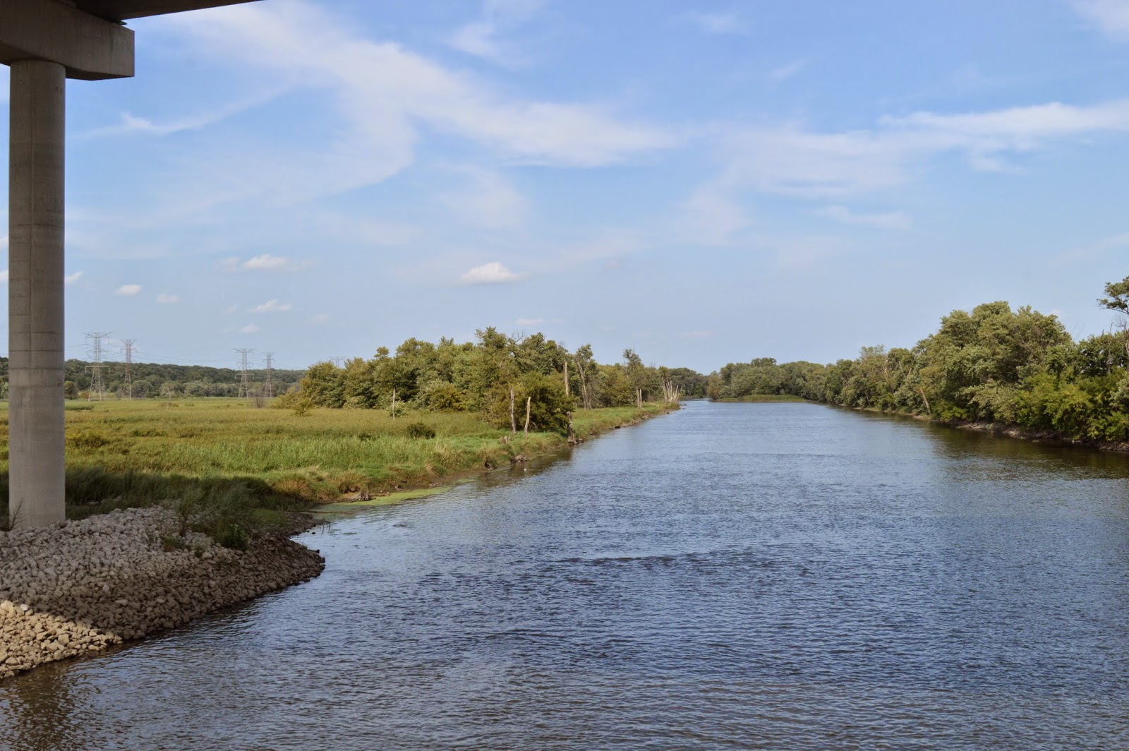
It then crosses quite a bit of wetlands until we get to the trail bridge that is over the Des Plaines River. This was built to provide access for construction, but it is now used for maintenance access to the trail and bridge. (I was impressed by the number of trash cans I saw along the trail.) The wetlands picture on the right was taken looking back after I had crossed the trail bridge.It is a small fraction of the total wetlands. The above link has links to more pictures.
 

Crossing the trail bridge, we see the Des Plaines River to the Southwest and to the Northeast.


The trail tees at a trail that follows the Sanitary and Ship Canal. And we see the breech in the Asian Carp Barrier. Unfortunately, they do not provide trail head parking at this south end of the trail even though there is plenty of room. If there was trail head parking here, the Des Plaines River Drive would no longer be private, and I could use it. Trail head parking is at the east end of the Canal Bank Road so the public can still use that road.


But the canal trail parallels the Des Plaines River Drive so learning how to bike again so that I can do that trail, and others, is on my todo list.


At the end of the trail bridge, I took this picture to illustrate a couple of items.


The box with the antennae on top had the signs to the right. (My picture was straight. The signs were crooked on the box.) The other item to notice above is the curve in the Asian Carp barrier fence. It goes around a fancy semi-circular paving. It is obviously an observation point. Unfortunately, after spending all of that money to make the observation point, they didn't spend any money on a sign explaining what you are supposed to be looking at. Furthermore, below is the best view I could find from that observation point. I assume the ragweed did not exist when they built it. And perhaps the foreground trees were much smaller. Is the point that the area has a swamp ecosystem as well as wetlands? I plan to revisit this view after the ragweed has died and the leaves are off of the trees.

I had noticed this observation point  on the right when I first crossed the trail, but at the time I could not figure out what I was supposed to see. I took this view when I came back because I noticed the structure on the left of the bigger picture, which the left picture zooms in on.


This picture was taken from the above observation point after I figured out later that I'm supposed to observe the structure. Note that plant growth has again defeated the purpose of the observation point. I had to hunt to find a gap in the growth. Fortunately, in this case there are alternative view points that allow you to see the structure. Unfortunately, there was not a sign to answer the question that occurred to me when I first spotted the structure---what was it?


When leaving, as I crossed back under the bridge, I took this view not to better understand the bridge but because of the strong geometry and because of the interaction between a man-made structure and nature.


Saturday, August 23, 2014

I-355 Des Plaines Valley Bridge vs. Wetlands

Al Pawloski posted
Hines Emerald Dragonfly!
The 1.3 mile I-355 Des Plaines River Valley Bridge crosses a pristine wetland that is home to 3 endangered species---Hine's Emerald Dragonfly, Blanding's Turtle, and Spotted Turtle. (Update: a different source lists the species as the Indiana Bat, the Hine's Emerald Dragonfly, and the Blanding's Turtle.) Of note for the Hine's Emerald Dragonfly is that the wetland lays on dolostone bedrock. In fact the bedrock is at the surface in Lemont where the I&M Canal had to be dug through it and in Lockport where there were surface quarries. Determining how to construct the bridge with a sufficiently small impact on the wetland and the endangered species delayed construction of the south extension from I-55 to I-80 by a decade.

(Update: EJ&E had to modify their locomotives to help protect the turtles.)

"The entire alignment was shifted to the west to avoid and minimize impacts to a nature preserve." (ConcreteProducts) The tollway authority built three additional dragonfly habitats in forest preserves in DuPage (Waterfall Glen), Cook, and Will (Wikipedia). The design was changed to raise the roadway 10-15 feet because the original height was at the average flying height of the dragonfly. (Walsh video, time mark 6:00) Only 34 piers are used to minimize the footprint. The permanent disturbance of the wetlands is 3.87 acres.

The wetlands extends from the Des Plaines River to the north bluff of the valley, and...

20140820 0054

...to the east all the way to Lemont Road.  The white tower in the distance is the top of the Hindu Temple of Greater Chicago.


It also extends quite a ways to the west. And there seems to be some prairie land that is being restored.


Below I zoomed in on some of the flowers. I spent quite a bit of time trying to frame the shot so that both purple flowers would show. The purple on the right is easy to see. The purple on the left looked better in "real life." It is not in this clump, but the prairie also had quite a bit of Queen's Anne Lace. It still needs some more time and/or work, because it also had quite a bit of ragweed.


An overview of the construction bridge that is now a trail/maintenance bridge, the I-355 bridge, the river, and part of the wetlands.


Another game of "Wheres Waldo." Can you spot the little yellow butterfly that caught my attention as I was leaving?


The butterfly is about a fourth from the left and a little below center. I lucked out because it had taken off and I caught it flying against a solid background.

Friday, August 22, 2014

Downers Grove Classic Car Night

Most Friday evenings during the Summer, Downers Grove reserves the parking on its downtown streets for classic cars (pre-1985). And the parking lots also fill up with classic cars. I finally remembered to grab my camera when we went to town to buy supper and look at the cars.

20140815 0606c

Many of the cars in this parking lot are classics parked there for the evening. I was trying hard to find a gap in the traffic to get a shot of the parking lot, but sometimes the traffic is part of the show.


And a view of that same lot from a corner. Note that it is party time for some of the exhibitors.


And down by the train station.


The track-side lot has vintage cars all the way from the station to the Washington Street crossing.


 One exhibitor that was on Main Street included some 1950s props.


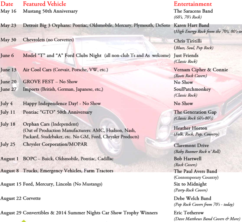
Each week specific models of cars are featured on Curtiss Street between Main and Washington. And live entertainment is offered at the Main Street Train Station. Every year, old trucks and tractors are featured in August. Unfortunately, I was in Florida this year during that week. These pictures were taken on "Ford night."


I just confirmed that the web page for the event disappears after a year so I am including a screen shot.


A lot of cars at the show are 1970s cars and Pontiac GTO and Cevy Super Sport (SS) are always well represented. But I seldom see Ford Torinos (the car I had in the 70s). One advantage of it being "Ford night" is that there were some Torinos.


The was only one car from the Model T/A era because they have a special night when that is the only models on the street.


Other cars that caught my eye on the "Ford block".


I overheard a conversation and learned that the engine in the Lincoln Continental is 460 cubic inches.