PU Tower: (Satellite)
Ironworks: (Satellite, by 1953, it was a Pensy railyard. Now it is a parking lot.)
Just a couple of blocks west of this station is the Delaware River Railroad Excursions.
Phillipsburg was the western terminus of the Morris Canal.
This Union Station is being restored as a museum. [friendsnjhc]
Track level view:
Street level view:
 |
| Street View, Nov 2021 |
Track level view:
 |
| Street View, Aug 2016 |
 |
| R. Donald Winship Photography posted Green and Gold Phillipsburg, NJ The recently repainted NS Reading Lines heritage unit leads NS train 22X past Phillipsburg Union station along CNJ's alignment. There is a *loose* relevance between subject and location -- the B&O controlled the CNJ via the Reading. |
 |
| Al Tilltston posted Norfolk Southern AC44C6M 4001 leads 6K4 east past the Phillipsburg NJ Union Station on Sunday morning June 29, 2025. |
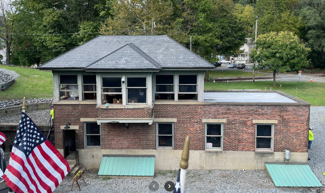
Thomas Dorman posted nine photos with the comment: "Union Station (Central Railroad of New Jersey and Delaware, Lackawanna & Western) built in 1914 in Phillipsburg, New Jersey, designed by Frank J. Nies, architect of the DL&W. On South Main Street near Hudson Street. 10 May 2025"
 |
| 1 |
 |
| 2 |
 |
| 3 |
 |
| 4 |
 |
| 5 |
 |
| 6 |
 |
| 7 |
 |
| 8 |
 |
| 9 |
I had to include a lot of the topo map in order to capture the railroad names. The tracks that went along the north side of the station were the DL&W and those that went south of the station were the Central Railroad of New Jersey. Norfolk Southern now has the routes that still exist.
 |
| 1953 Easton Quad @ 24,000 |
Just a couple of blocks west of this station is the Delaware River Railroad Excursions.
 |
| 877trainride [They offer several different types of train rides. But, like other tourist railroads, their web site doesn't have a map showing where the trains go.] |
CNJ "PU" Tower
 |
| E. Miller, Sep 2023 |
 |
| Al Tillotson posted Central RR of New Jersey PU tower, Phillipsburg NJ, Wednesday morning March 20, 2019. |

 |
| E. Miller, Sep 2023 |
Lost/Andover Ironworks/Cooper-Hewitt Works
Metrotrails posted two photos with the comment:
Metrotrails Then and Now Series: Historic Phillipsburg, New Jersey scene on the slopes near Delaware Heights along the Delaware River, looking toward the Andover Ironworks, compared to the same scene on our 2020 hike.Previously known as the Cooper-Hewitt Works, the operation dominated the Delaware Riverfront in Phillipsburg at the turn of the twentieth century.Here, we see the Belvidere-Delaware Railroad (Pennsylvania Railroad) approaching the furnace, which is now a popular excursion line. It crosses over the Lopatcong Creek just prior to the furnace. The Morris Canal passed along the east side of the furnace, present site of the Andover Morris Elementary School...
Metrotrails shared
 |
| 1 |
 |
| 2 |
The trees made it hard to find the Lapatcong Creek. Fortunately, Google labels it if I zoom in close enough. I could not find the school.
 |
| Satellite |
An older topo shows the canal.
 |
| 1891 Eaton Quad @ 62,500 |
Roundhouses
.jpg) |
| Phil Craig posted Map of Phillipsburg NJ. Over the years they had at least 7 or 8 [roundhouses]. Not sure how many can still be located. William L. Vanderburg: You can see at least 3 from google earth. The one north of the center river crossing is where the steam train ride is now. That train ride actually passes the land area where the rh at the bottom of the map is located. But if you didn’t know it was there, it wouldn’t mean anything to you. |
 |
| Tim Starr posted Phillipsburg NJ had six roundhouses within a few blocks of each other in 1900. At the top is the Belvidere and Delaware, 8 stalls, gone a few years later. The two next to each other are Central of New Jersey (16 stalls and 19 stalls, built in 1865). The rectangle shaped one at right is Morris and Essex (later DL&W). The one at bottom left is the Pennsylvania RR, 12 stalls. There was even another 3-stall roundhouse just west of here (not on the map) by the Lehigh and Hudson River. John Sanheim: Looks like when this drawing was made the two roundhouses were no longer in use as the turntable and housing tracks are gone. Some old roundhouses were re purposed after steam and used as other types of shops. Those two have no track access. |
 |
| Tim Starr commented on John's comment They were still active. The artist just didn't draw the TT or tracks. |
No comments:
Post a Comment