In addition to the main canal going east/west through town, Fort Wayne had a feeder canal to the north to tap the St. Joseph River at a higher elevation.
 |
| Great Memories and History of Fort Wayne, Indiana posted |
 |
| Great Memories and History of Fort Wayne, Indiana posted Eric L Lucas I believe the canal was filled in and the nickel plate railroad was built on top. Does anyone know if that is right? Christopher Rorick I do believe the canal and the railroad are the same starting in new haven then heads west. Joy Bronson-mccrady Christopher Rorick Hi Chris, there is an historian from St Paul New Haven church named Ross Hockemeyer. He did some excellent writing on the canal. It used to run roughly along old Hwy 24 to the east. You might want to see if you can find any of Ross' writings on this. Very interesting fellow. He always owned and his family still owns property along the river and old 24. |
 |
| David Shaw posted Dock street. The north side of Columbia st. Also known as The Landing. [During the canal days, this would have been the front of the buildings.] |
 |
| Jeff Smith commented on David's posting Here’s a map that shows how downtown Fort Wayne was configured in 1855 during peak of the canal era. |
 |
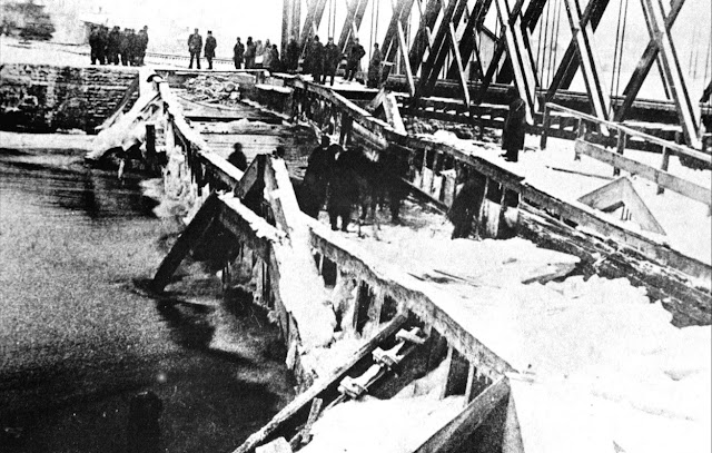
| Rick Stabler posted The remains of the Wabash & Erie canal viaduct looking west across the St. Mary's river after ice damage, circa 1888. The aqueduct was a 160 feet long water-filled trunk that passed floating commerce between America’s Eastern Seaboard and to the Mississippi River valley markets. To the east, and related to canal lore, is Fort Wayne’s smallest park, Orff Park. Marked by a statue of two young boys, it recalls the Aqueduct Club formed in 1912 in memory of those who made the canal aqueduct their swimming hole. ACPL online collection and History Center Notes & Queries. Eric A Zerkle Looked pretty well trashed by 1888 Nancy Parker once railroad came in,not used,sold right of way to Nickle Plate in 1881. Eric A Zerkle Think it was shut down in 1860. |
 |
| Rick Stabler commented on his post The canal ran under the railroad tracks and crossed the river on the southside of the present day railroad trestle. [Satellite] |
Rick Stabler posted two photos with the comment:
The old stone mill (Edsall/Orff mill) at west Main street has been posted here before. Here is a neat drawing and description of how that mill operated in conjunction with the Wabash & Erie canal.Ben Klinger
"Orff Mill had several names throughout its history. Sometimes called the “Edsall Mill,” it later was known as the “Empire” and commonly called “the old stone mill” when it stood while the machinery was operated by Wabash and Erie Canal waterpower. A pond was installed on the east side of the building that supplied water to the wheel on the southside of the building which flowed into a small basin that led to the river. The mill was built by Samuel Edsall in 1843. Milford Smith was an early partner and later the business passed on to Orff, Armstrong & Lacy, but John Orff afterward became the sole proprietor. Later his sons John Jr., C.E. and Montgomery Orff took control of the operation. In its final years the mill was powered by steam. It stood on east bank of the Saint Mary’s river near the “Let’s Go Swimming” statue." Saint Mary’s River Aqueduct No. 1 was built in 1835 and rebuilt in 1871. It carried the Wabash & Erie Canal across the Saint Mary’s until 1882. The wooden flume was two spans, each eighty feet in length, seventeen feet wide, four and one-half feet deep and was supported on three great stone pillars. The water of the canal was specified to be at least four feet deep and moved about five miles an hour through the aqueduct, at a weight of more than 450 tons.
A roof was built over the channel, giving it the appearance of a covered bridge. At the west end, just past the aqueduct, a large basin was created so that the canal boats could turn around or wait for another one to pass. It was here in the basin and in the aqueduct itself that the boys often played.
In 1881, the Nickel Plate Railroad purchased the canal right-of-way, including the aqueduct and erected the steel bridge for the trains that still stands today just north of the aqueduct’s location. The aqueduct soon collapsed into the river and was removed in 1883." -ACPL online collection and History Center Notes & Queries
 You can still see some remnants of the aqueduct just south of the railroad bridge.
 |
| 1 |
 |
| 2 |
No comments:
Post a Comment