Tuesday, September 6, 2016

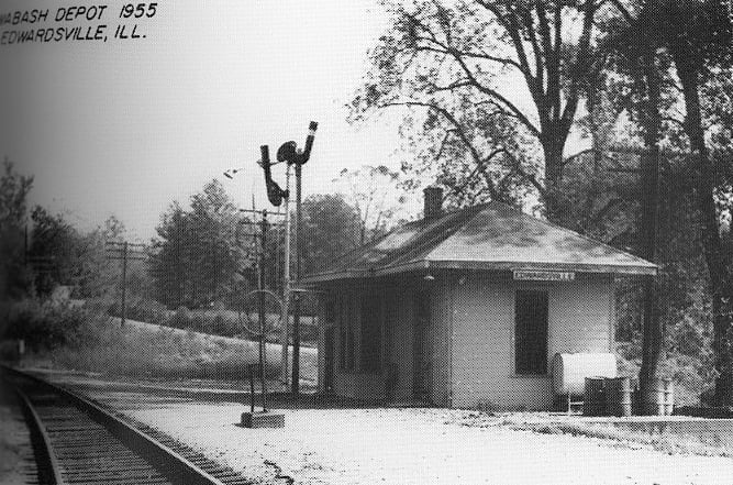
Edwardsville, IL: Wabash Depot

(Satellite, per James' satellite image below.)

William Shaffer posted
Wabash Depot at Edwardsville, IL
(Photo by William A. Shaffer)
I shot this photo during the Summer of 1971, after Amtrak had taken over National Passenger Service. Much to their relief, the N&W route between Chicago & St. Louis was not chosen, losing out to the GM&O. The Detroit-St. Louis Route was also not chosen, ending all passenger service through Edwardsville. Most of my trips began or ended here, at this small depot that was almost impossible to find! The depot is now gone, as is the second track and the roadway going down to the depot. I go back here every couple of years just to see what has happened here.
William Shaffer posted again
The Wabash Depot at Edwardsville, IL (Circa Summer, 1971)
(Photo by William A. Shaffer)
This is where most of my trips on the former Wabash Railway began or ended: Edwardsville, IL. My very first train ride began here, back in good old 1958! It was the beginning of my love affair with passenger trains! The scene looked the same in 1958 and it did in 1971, except by May 1, 1971, there were no passenger trains stopping here any longer. Today, the depot itself is gone, as is the second track. It is overgrown with brush and if you didn't know there had been a depot here, you would never have guessed it. It's simply the passage of time!
William Shaffer posted again
Wabash Depot - Edwardsville, IL. (August, 1971)
(Photo by William A. Shaffer) 
As I recall, this was a two-room depot: Waiting Room and Agent's Office/Baggage Room. If you didn't know how to get down to the depot, it could be tricky to find. You could see it clearly from IL Highway 159 but getting down there was the trick! The depot was torn down many years ago and the second track was removed also!
Gary Forshaw: It was a waiting room and an office. The bathroom occupied a corner of the waiting room.
James Holzmeier commented on the above posting

Zooming in, you can see the Iron Men on both sides of the mainline.
1941 Aerial Photo from ILHAP
Near the bottom at the end of the road and next to the trees.

David Cantrell posted
An Ebay listing has a photo of the Edwardsville Wabash depot during a flood. The back of photo says 5 feet of water in the building. 
Towns and Nature Blog by Dennis DeBruler gives location of depot was at this link: https://maps.app.goo.gl/zHrb8wBmBr63XSjm9
Richard Fiedler shared

William A. Shaffer posted
Wabash Depot - Edwardsville, IL   (Photographer Unknown)

William A. Shaffer posted
Making the Station Stop at Edwardsville. 
Edwardsville, IL
(Photo by William A.Shaffer)
Nothing made a passenger train prettier than to have an EMD E-Unit or an Alco PA on the head end and an observation car on the rear end.  Here is N&W #301, the "Wabash Cannon Ball" making its stop at Edwardsville.  E8A#3808 has the honors!
 
Andy Zukowski posted
A picture of the Wabash Railroad Depot in Edwardsville, Illinois taken in 1973.
Paul Bourjaily: Kinda surprised to see a semaphore in '73.
Richard Fiedler shared
William Ankrom: The agent was doing good that's a new car then!
Jim Kelling shared
 
Andy Zukowski posted
The Norfolk & Western Depot in Edwardsville, Illinois, 1971.
Ray Peacock: Superelevation on display!
Michael C Kelly: The IT’s line from Edwardsville to Alton is in the tree line in the background, and would cross the N&W on a bridge just out of the photo to the right.
Steven Hooker shared

Flickr has a flipped image.

Sunday, September 4, 2016

Freeport, IL: Railroad Hub

Satellite
Red: IC charter line (west part exists as CN, south part was abandoned by ICG)
Yellow: Aban/C&NW/G&CU
Green: Aban/Milwaukee
Blue: CM&N (east part exists as CN, west part was abandoned in 1942 (FD&N) and 2000 (WICT...ICG...CM&N)

If you count the branches that fork off in the vicinity of Freeport, it used to have eight "spokes" and four railroad bridges. Now it has two spokes and two trail bridges.

1944 Freeport Quad @ 62,500

Illinois Central was the first land grant charter created by the Federal government. Back then, Galena was a prosperous river town because of the lead mines in the area. Many considered Chicago a glorified trading post in a swamp. But some people had the vision to realize that Galena was stagnant and Chicago was enjoying vigorous growth, in part because of the I&M Canal. So a "branch" was also built from Centralia, IL to Chicago. In fact, IC created the town of Centralia. The land-grant route went north through the center of the state to Freeport, then turned west to Galena. The red line roughly indicates how the IC charter line went through town.

Another early railroad was the C&NW/Galena & Chicago Union. In fact, it was the first railroad in Chicago. It built from Chicago towards Galena. However, they never reached Galena. Freeport was the terminus because C&NW started building a more direct route to the transcontinental terminus in Omaha, NE from West Chicago. The original C&NW route now terminates in Rockford since the segment between Rockford and Freeport has been abandoned. It is easy to find the treelines and land scars of the route east of US-20.
1939 Aerial Photo from ILHAP
I switched to a 1939 aerial to see how it ran past the curves in the river. Knowing where it ran, you can still see a pier of its bridge and a "groove" in a stand of trees where it curved and ran north of IC's route, past the Union Depot and terminated at a set of buildings that is now a parking lot. The yellow line indicates the C&NW route.

From 1854, the IC used the C&NW for traffic between Galena and Chicago. By the 1880s they decided they were loosing too much business. Furthermore Wisconsin was growing rapidly and they wanted to directly tap into that market. So in July of 1886 IC charted the Chicago, Madison & Northern. The blue lines indicate the IC spokes built by CM&N --- one goes east to Chicago starting at the East Junction and another goes north to Madison, WI, starting at the West Junction. Another IC spoke, Freeport, Dodgeville & Northern, branched off the Madison spoke north of Red Oak, IL and is off the color coded map.

The Milwaukee Road had a branch that ran from Kittredge on their east/west mainline through Freeport to Rockton on a branch that went north of Rockford. The green line shows its route through town including a crossing of the river. You can see a closeup of the south side in the East Junction map. (Update: I had forgotten that the Milwaukee also came through this town until I came across this posting in a Milwaukee group. A silver lining of floods is that people take pictures of railroad infrastructure --- Milwaukee's depot and freight house. Railfans generally take pictures of just locomotives.)

In the 1980s, Chicago Central and Pacific bought the west part of the charter line and the east part of the CM&N. These two spokes are now owned by the CN because the IC bought the route back from CC&P in 1996.
 
John Cook posted
Freeport, Illinois Chamber of Commerce 1925.

Rory Peterson posted two photos with the comment:
Continuing the Freeport views: -A postcard view of a flooded Milwaukee Road.
-Chicago and North Western C-6 engine 99, Schenectady 1893. Scrapped on 11-13-1928./ McConnell Area Historical Society collection
1

2

Freeport, IL: Honeywell Plants 1, 2, 3, 4, and 6

I discovered Plant 1 while researching railroad yards in the town. When I researched Plant 1, I discovered that Honeywell has several locations in Freeport.

"The company manufactures automatic environmental controls for residential, commercial and appliance use." [JournalStandard]
Plant 1: Satellite
Plants 2: Satellite  Streetview
Employs about 900 people and was sold to Sensata Technologies Holding in 2010 for $140 million. "The deal is expected to build the company’s market share in Asia, specifically China, the world’s fastest-growing automotive sensors market." [RRstar]
Plant 3: Satellite  Streetview
Plant 4: Satellite

Friday, September 2, 2016

Richmond, IN: C&O Depot & Freight House?, Junction Tower: C&O vs. Penssy and Modern Purina Feed Mill

Depot: (Satellite)
Junction: (Satellite, the Cardinal Greenway trail was the C&O.)
Mill: (Satellite)

Street View

The contemporary photo indicates it is along an abandoned route. According to a satellite image, the CSX has abandoned the track north of S G Street. 
Donald Burden posted
The C&O depot has not fared so well, as revealed by the ca. 1908 postcard.

Donald Burden posted

Raymond Storey posted
RICHMOND IND

Brad McClelland posted
C&O station in Richmond, Indiana. The station was located at MP-60 on the now abandoned Miami Subdivision.
January 2, 1984
Robert Daly: In December 1974 I took Amtrak's National Limited from Pittsburgh to Richmond and spent a few hours in this station waiting for the northbound George Washington (now the Cardinal) to Chicago. During the Seventies the GW and Cardinal kept moving from one railroad to another as track conditions deteriorated.
 
Pam Simpson Moleski commented on Brad's post
Rick & I photographed this station 23 years later, looking the worse for wear, on January 24, 2017.

Was the white building the freight house? According to a current satellite image, that building no longer exists.
Street View, Oct 2007

Rob Kunkle posted three photos with the comment: "Richmond Indiana railroad depot. C,R,&M. Then CC&L. Then C&O. Then Chessie. Lastly CSX."
Rob Kunkle shared
[Some comments indicated this is like the depots in New Castle and Peru and that those depots are in better shape.]
1

2

3

The C&O used to go through town near the river.
1960 Richmond Quad @ 1:24,000

The route through town is abandoned and the route north of the depot is now the Cardinal Greenway trail.
Bryan Monaco posted
The former C&O in Richmond, Indiana, near Main St.
Ken Miller: Coal dock?
John Rose: Ken Miller Yes, the Richmond Gas Co. plant would convert coal to coal gas. Dirty process.
The C&O is now the Cardinal Greenway starting just north of this spot. This section of track is abandoned. A few blocks south the track is in place and ostensibly still in service but the last 2 customers on the south side (Richmond Power & Light and Richmond Recycling Center) are no longer using rail. Nearest customer is an ag products operation roughly 5 miles further south in Boston, Indiana.

Tim Shanahan shared

Street View

Dennis Born posted four photos with the comment: "Off the C&O The abandoned former Amtrak station and depot at 3rd and C st.  rails long ripped up still awesome to see."
Jim Kelling shared with the comment: "Richmond Indiana (C&O station)."
Dennis Born posted the first three photos with the comment: "Long abandoned freight house and Amtrak Station .... 👀👍— in Richmond, IN."
1

2

3

4

Junction Tower


Lori Ann Edward Hamilton posted
this also richmond ind looking west the intrelocking tower was located around sharidan street bridge 2 tracks went north you can faintly see 5th st bridge in the backround the other 2 tracks went west to ind
Tim Shanahan shared

Joe Smith commented on Lori's post

Feed Mill


Street View, Aug 2024

Street View, Aug 2024

Josh Imhoff, Feb 2023

VLad B, May 2021


Richmond, IN: PRR Depot

It took me a while to find it: satellitestreet view. It looks like Richmond still enjoys quite a bit of rail served industry.


Donald Burden posted
Thanks to recent restoration efforts, the Pennsy station is looking more like its old self, minus the enormous train shed that once extended off the rear of the building.

Donald Burden posted

William Shapotkin posted, cropped
A friend of mine and I spent the day in Richmond, IN and look what we found -- The Richmond PRR psgr station is alive and well (and now home to a local real estate dealer) and part of "The Depot District," which includes a mural of a PRR trn on it! View looks W-N/W.
Photo taken by Richard Aaron on Aug 23, 2021. Posted with Permission.

Street View

Street View

This photo has been moved to "Pennsy Roundhouse and Railyard."

The train shed here was similar to the one that GR&I had in Grand Rapids.
Gordon 'Tim' Curtis posted via Dennis DeBruler
Train Shed Union Depot,  Grand Rapids, Michigan. Postmark 1910
Mike Snow shared

Fred Farlow posted
Depot area. Not great quality, old newspaper clipping.  Lots of interesting stuff in the pic.  1935
[Some comments think the date of the photo is more like the early 1950s.]